Home > Europe > Italy > Emilia-Romagna > Mirandola
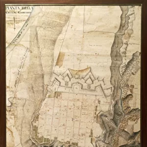
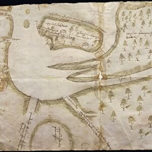
Plan of the fortress of Mirandola, Lombardy region by architect Amedeo Peloja, from Military Architecture, drawing, 1550

![]()
Wall Art and Photo Gifts from Universal Images Group (UIG)
Plan of the fortress of Mirandola, Lombardy region by architect Amedeo Peloja, from Military Architecture, drawing, 1550
Cartography, Italy, 16th century. Plan of the fortress of Mirandola, Lombardy region. Drawing by architect Amedeo Peloja, from Military Architecture, 1550
Universal Images Group (UIG) manages distribution for many leading specialist agencies worldwide
Media ID 9505425
© DEA PICTURE LIBRARY
16th Century Drawing Fortress Geography Lombardy Military Plan Western Script Mirandola
FEATURES IN THESE COLLECTIONS
> Architecture
> Country
> Italy
> Related Images
> Architecture
> Drawings
> Europe
> Italy
> Emilia-Romagna
> Mirandola
> Europe
> Italy
> Lombardy
> Related Images
> Europe
> Italy
> Sculptures
> Universal Images Group (UIG)
> Art
> Painting, Sculpture & Prints
> Cartography
EDITORS COMMENTS
This print showcases the intricate "Plan of the fortress of Mirandola" in Lombardy, Italy, meticulously designed by architect Amedeo Peloja during the 16th century. The drawing, featured in Military Architecture, provides a fascinating glimpse into the strategic layout and topography of this formidable stronghold. With its vertical orientation and precise cartographic details, this illustration offers a comprehensive view of the fortress's design. Every wall, tower, and gate is intricately depicted with Western script annotations to guide military strategists through its complex structure. The artist's skillful rendering transports us back to an era when fortresses played a crucial role in defending territories. This particular plan exemplifies both practicality and artistry as it combines elements of geography and architecture seamlessly. As we explore this image further, we can appreciate how Peloja's expertise shines through his attention to detail. Although devoid of people or any signs of activity, this blueprint evokes a sense of awe for the meticulous planning that went into constructing such an imposing defense system. Whether studied by historians or admired by enthusiasts intrigued by Italian military history, this remarkable print from Universal Images Group (UIG) serves as a testament to Amedeo Peloja's architectural prowess and contributes valuable insights into Lombardy region's rich cultural heritage.
MADE IN THE USA
Safe Shipping with 30 Day Money Back Guarantee
FREE PERSONALISATION*
We are proud to offer a range of customisation features including Personalised Captions, Color Filters and Picture Zoom Tools
SECURE PAYMENTS
We happily accept a wide range of payment options so you can pay for the things you need in the way that is most convenient for you
* Options may vary by product and licensing agreement. Zoomed Pictures can be adjusted in the Cart.