Home > Universal Images Group (UIG) > Art > Painting, Sculpture & Prints > Cartography
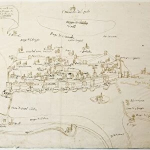
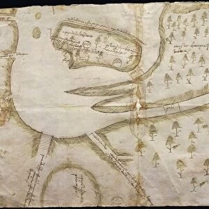
Map of Constantinople and Marmara Sea, from Tabula Peutingeriana, Peutinger table, medieval map of Roman roads, copy after Roman original, drawing

![]()
Wall Art and Photo Gifts from Universal Images Group (UIG)
Map of Constantinople and Marmara Sea, from Tabula Peutingeriana, Peutinger table, medieval map of Roman roads, copy after Roman original, drawing
Cartography, 12th century. Map of Constantinople and Marmara Sea. From the Tabula Peutingeriana (Peutinger table), medieval map of Roman roads, copy after a Roman original. Drawing
Universal Images Group (UIG) manages distribution for many leading specialist agencies worldwide
Media ID 9505521
© DEA PICTURE LIBRARY
12th Century Coastline Constantinople Copy Drawing Geography Medieval Roman
EDITORS COMMENTS
This print showcases a remarkable piece of cartographic history - the Map of Constantinople and Marmara Sea. Dating back to the 12th century, this drawing is a copy after a Roman original found in the Tabula Peutingeriana (Peutinger table), an invaluable medieval map of Roman roads. The intricate details depicted on this horizontal illustration offer us a glimpse into the topography and geography of ancient Constantinople. The city's majestic coastline along the Marmara Sea is beautifully captured, highlighting its strategic location as a vital hub for trade and commerce during that era. As we explore this historic map, it becomes evident that it was meticulously crafted with precision and care. Every road, street, and landmark within Constantinople is intricately etched onto parchment, providing us with valuable insights into how Romans navigated their way through this magnificent city centuries ago. Although devoid of people or any signs of modernity, this drawing transports us back in time to experience Constantinople's grandeur firsthand. It serves as a testament to the mastery of cartography during medieval times and reminds us of the importance placed on accurate mapping even in those early days. This print from Universal Images Group (UIG) allows us to appreciate not only the artistry involved but also provides historians with valuable information about ancient Roman infrastructure and urban planning. A true treasure for enthusiasts interested in both geography and history alike!
MADE IN THE USA
Safe Shipping with 30 Day Money Back Guarantee
FREE PERSONALISATION*
We are proud to offer a range of customisation features including Personalised Captions, Color Filters and Picture Zoom Tools
SECURE PAYMENTS
We happily accept a wide range of payment options so you can pay for the things you need in the way that is most convenient for you
* Options may vary by product and licensing agreement. Zoomed Pictures can be adjusted in the Cart.