Home > Aerial Photography > Related Images
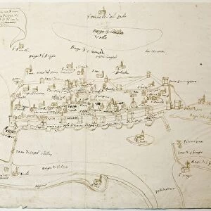
Map of the port of Puerto Rico and Santo Domingo, drawing by Figueroa, 1519

![]()
Wall Art and Photo Gifts from Universal Images Group (UIG)
Map of the port of Puerto Rico and Santo Domingo, drawing by Figueroa, 1519
Cartography, 16th century. The port of Puerto Rico and Santo Domingo. Drawing by Figueroa, 1519
Universal Images Group (UIG) manages distribution for many leading specialist agencies worldwide
Media ID 9505573
© DEA / M. SEEMULLER
1519 16th Century Aerial View Antilles Coastline Dominican Republic Drawing Field Guidance Harbor Human Settlement Island Navigational Equipment Puerto Rico Santo Domingo Figueroa Non Urban Scene
FEATURES IN THESE COLLECTIONS
> Aerial Photography
> Related Images
> Arts
> Art Movements
> Landscapes
> Arts
> Contemporary art
> Landscapes
> Sculptures
> Arts
> Contemporary art
> Sculpture
> Landscape paintings
> Arts
> Landscape paintings
> Landscape art
> Landscape paintings
> Arts
> Landscape paintings
> Landscape art
> Nature-inspired artwork
> Arts
> Landscape paintings
> Landscape art
> Arts
> Landscape paintings
> Nature-inspired artwork
> Arts
> Still life artwork
> Landscape paintings
> Nature-inspired artwork
> Universal Images Group (UIG)
> Art
> Painting, Sculpture & Prints
> Cartography
EDITORS COMMENTS
This print showcases a remarkable piece of cartography from the 16th century - a map of the port of Puerto Rico and Santo Domingo, drawn by Figueroa in 1519. The intricate details and precision displayed in this drawing offer us a glimpse into the past, revealing the topography and layout of these historical islands. As we immerse ourselves in this image, we are transported back to an era when navigational equipment was rudimentary at best. This map served as an invaluable tool for sailors and explorers seeking guidance through treacherous waters, providing them with essential information about harbors, coastlines, and human settlements. The aerial view captured here allows us to appreciate the natural beauty of these Caribbean destinations. The lush landscapes blend harmoniously with the azure sea surrounding them, creating a picturesque scene that is both inviting and awe-inspiring. In this non-urban setting devoid of people, we can almost hear echoes from history reverberating through time. It reminds us of the rich cultural heritage embedded within these lands - Puerto Rico's vibrant mix of indigenous Taíno traditions with Spanish influences, alongside Santo Domingo's role as one of the oldest European settlements in the Americas. This artful illustration transports us on a journey back to 1519 when exploration was at its zenith. It serves as a testament to humanity's ceaseless curiosity about our world and our relentless pursuit to chart new territories. Let this historic masterpiece ignite your imagination as you delve into centuries-old
MADE IN THE USA
Safe Shipping with 30 Day Money Back Guarantee
FREE PERSONALISATION*
We are proud to offer a range of customisation features including Personalised Captions, Color Filters and Picture Zoom Tools
SECURE PAYMENTS
We happily accept a wide range of payment options so you can pay for the things you need in the way that is most convenient for you
* Options may vary by product and licensing agreement. Zoomed Pictures can be adjusted in the Cart.