Home > Arts > Landscape paintings > Waterfall and river artworks > River artworks
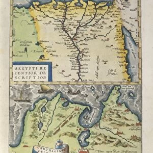
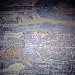
Map featuring Mesopotamia and Tower of Babel, engraving

![]()
Wall Art and Photo Gifts from Universal Images Group (UIG)
Map featuring Mesopotamia and Tower of Babel, engraving
Cartography, Asia, 17th century. Map featuring Mesopotamia and the Tower of Babel. Engraving
Universal Images Group (UIG) manages distribution for many leading specialist agencies worldwide
Media ID 9570803
© DEA PICTURE LIBRARY
17th Century Ancient Culture Archeology Euphrates Illustration Technique Mesopotamia Old Ruin Palm Tree People In The Background River Road Non Urban Scene Tower Of Babel Ziggurat
FEATURES IN THESE COLLECTIONS
> Arts
> Landscape paintings
> Waterfall and river artworks
> River artworks
> Asia
> Related Images
> Universal Images Group (UIG)
> Art
> Painting, Sculpture & Prints
> Cartography
EDITORS COMMENTS
This 17th-century engraving takes us back in time to the ancient lands of Mesopotamia, where history and myth intertwine. The intricate map showcases the physical geography of this region, with its mighty Euphrates River meandering through vast plains dotted with palm trees. In the foreground stands a remarkable sight - the legendary Tower of Babel, reaching towards the heavens. The Tower of Babel has long fascinated scholars and storytellers alike. According to biblical accounts, it was an ambitious construction project that aimed to bridge heaven and earth. However, divine intervention disrupted their plans, resulting in a multitude of languages being spoken by humanity. As we gaze upon this engraved image, we are transported to a non-urban scene filled with remnants of an ancient culture. The old ruins evoke a sense of mystery and wonder as we imagine what life must have been like during those times. The illustration technique employed in this print is truly masterful; every line and detail brings forth a sense of authenticity and reverence for these historical landmarks. It serves as a testament to both the artistry involved in cartography during this era and our enduring fascination with exploring the past. Whether you are an archaeology enthusiast or simply captivated by antiquities, this mesmerizing print offers a glimpse into one of humanity's most intriguing chapters - Mesopotamia's rich heritage that continues to inspire us today.
MADE IN THE USA
Safe Shipping with 30 Day Money Back Guarantee
FREE PERSONALISATION*
We are proud to offer a range of customisation features including Personalised Captions, Color Filters and Picture Zoom Tools
SECURE PAYMENTS
We happily accept a wide range of payment options so you can pay for the things you need in the way that is most convenient for you
* Options may vary by product and licensing agreement. Zoomed Pictures can be adjusted in the Cart.