Home > Arts > Artists > O > Abraham Ortelius
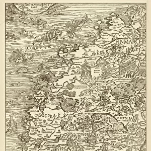
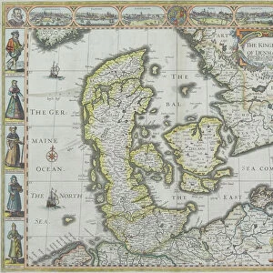
Orteliuss map of Denmark, 1570

![]()
Wall Art and Photo Gifts from Science Photo Library
Orteliuss map of Denmark, 1570
Orteliuss map of Denmark. This map is from the 1570 first edition of Theatrum orbis terrarum ( Theatre of the World ). Drawn by the Flemish mapmaker Abraham Ortelius (1527-1598), and published by Gilles Coppens de Diest in Antwerp, this collection of 53 maps is considered to be the first true modern atlas
Science Photo Library features Science and Medical images including photos and illustrations
Media ID 6298957
© LIBRARY OF CONGRESS, GEOGRAPHY AND MAP DIVISION/SCIENCE PHOTO LIBRARY
1500s 1570 1570 Edition 16th Century Abraham Ortelius Age Of Discovery Antwerp Edition Cartographic Cartography Country Danish Denmark Dutch First Edition First Modern Atlas Flemish Gilles Coppens De Diest Latin Latin Edition Nation Orteliuss Text Theatre Of The World Theatrum Orbis Terrarum Writing Dania
FEATURES IN THESE COLLECTIONS
> Arts
> Artists
> O
> Abraham Ortelius
> Maps and Charts
> Abraham Ortelius
EDITORS COMMENTS
This print showcases Orteliuss map of Denmark, a remarkable piece of cartographic art from the 16th century. Created by Abraham Ortelius, a renowned Flemish mapmaker, this particular map is part of the first edition of Theatrum orbis terrarum (Theatre of the World), published in 1570 by Gilles Coppens de Diest in Antwerp. Comprising a collection of 53 maps, this work is widely regarded as the first true modern atlas. It provides an invaluable glimpse into European geography and history during the Age of Discovery. The intricate details and meticulous craftsmanship evident in this illustration highlight Ortelius's expertise and dedication to his craft. Displayed against a backdrop of Latin text, which adds an air of authenticity to the composition, this map offers viewers a window into Denmark's past. Its depiction captures not only the geographical features but also reflects the political boundaries and cultural nuances prevalent at that time. As we admire this historical gem, it serves as a reminder that maps are not merely tools for navigation; they are works of art that encapsulate our understanding and interpretation of our world throughout different eras. This photograph preserves both scientific knowledge and artistic beauty for generations to come.
MADE IN THE USA
Safe Shipping with 30 Day Money Back Guarantee
FREE PERSONALISATION*
We are proud to offer a range of customisation features including Personalised Captions, Color Filters and Picture Zoom Tools
SECURE PAYMENTS
We happily accept a wide range of payment options so you can pay for the things you need in the way that is most convenient for you
* Options may vary by product and licensing agreement. Zoomed Pictures can be adjusted in the Cart.