Home > Science > Space Exploration > Planets > Earth
South America, satellite image

![]()
Wall Art and Photo Gifts from Science Photo Library
South America, satellite image
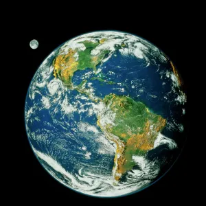
Antarctica. Satellite image of the Earth, set against a background of stars, centred on the Antarctic. The South Pole is at centre. Clouds (white) are seen in the atmosphere. On the surface, seas and oceans (blue) surround the land, with ice (white) covering Antarctica. Land cover further north ranges from vegetation (green) to arid areas (brown). Antarctica is surrounded by the Southern Ocean. The tips of Africa (lower right) and South America (upper right), all of New Zealand (centre left) and the southern parts of Australia (lower left) are also seen. This image, from 2001, combines data from a variety of satellite sensors (AVHRR, SeaWiFS, MODIS) at a range of wavelengths
Science Photo Library features Science and Medical images including photos and illustrations
Media ID 6349527
© NASA/NOAA/SCIENCE PHOTO LIBRARY
2001 Antarctic Antarctica Arid Avhrr Back Ground Circle Circular Cloud Cloud Cover Clouds Cloudy Continent Continental Continents Day Time Desert Deserts Earth Observation Earth Science From Space Globe Hemisphere Ice Cap Image Land Land Cover Meteorological Meteorology Modis Photos Plain Plains Planetary Polar Region Round Satellite Satellite Image Sciences Seas Seawifs Snow South Pole Stars Topographical Topography Weather World
FEATURES IN THESE COLLECTIONS
> Science Photo Library
> Aerial and Satellite
> Science
> Space Exploration
> Planets
> Earth
> Science
> Space Exploration
> Satellite Imagery
EDITORS COMMENTS
This print showcases a stunning satellite image of South America, with Antarctica taking center stage. Against the backdrop of twinkling stars, this image provides a mesmerizing view of our planet from space. The South Pole is prominently displayed at the heart of Antarctica, surrounded by vast expanses of white ice that cover the continent. Moving further north, we witness a diverse range of land cover - from lush green vegetation to arid brown regions. The Southern Ocean gracefully encircles Antarctica, while other notable features come into view as well. In the lower right corner lies Africa's tip and in the upper right corner stands South America. Additionally, we can observe New Zealand occupying the center left portion and parts of Australia visible in the lower left section. This remarkable composite image was created in 2001 using data collected by various satellite sensors such as AVHRR, SeaWiFS, and MODIS across different wavelengths. It beautifully captures Earth's topography and weather patterns including cloud formations (depicted in white) within its atmosphere. As an awe-inspiring representation of our planet's geography and meteorology taken from space during daylight hours, this photograph offers a glimpse into Earth science at its finest. With its intricate details showcasing continents, oceans, deserts, clouds and more – it serves as a testament to humanity's continuous exploration and understanding of our extraordinary world.
MADE IN THE USA
Safe Shipping with 30 Day Money Back Guarantee
FREE PERSONALISATION*
We are proud to offer a range of customisation features including Personalised Captions, Color Filters and Picture Zoom Tools
SECURE PAYMENTS
We happily accept a wide range of payment options so you can pay for the things you need in the way that is most convenient for you
* Options may vary by product and licensing agreement. Zoomed Pictures can be adjusted in the Cart.