Fraud Blocker Skip to main content

Region Collection

Explore the captivating world of regions through a journey across time and space

Background imageRegion Collection: Coast at Claddaghduff with Omey Island, Connemara, County Galway, Republic of Ireland, Europe

Coast at Claddaghduff with Omey Island, Connemara, County Galway, Republic of Ireland, Europe

Background imageRegion Collection: A map of the Colne Valley Cloth District

A map of the Colne Valley Cloth District
Pictorial map of the Colne Valley Cloth District in Yorkshire, drawn by the poster artist and designer Leslie MacDonald Gill the year before his death, in 1946

Background imageRegion Collection: HMS Erebus and HMS Terror, 1845

HMS Erebus and HMS Terror, 1845
Engraving showing HMS Erebus (left) and HMS Terror, pictured on the River Thames, 1845. In 1845 the British Admiralty sent two polar exploration ships, HMS Erebus and HMS Terror

Background imageRegion Collection: Orteliuss map of Ottoman Empire, 1570

Orteliuss map of Ottoman Empire, 1570
Orteliuss map of the Ottoman Empire. This map is from the 1570 first edition of Theatrum orbis terrarum ( Theatre of the World )

Background imageRegion Collection: Lebanon - Zahle

Lebanon - Zahle
The Wadi (the Arabic term traditionally referring to a valley) at Zahle, Lebanon. The Beqaa Valley wine region. Date: circa 1920s

Background imageRegion Collection: Captain Francis Crozier of HMS Terror, 1845

Captain Francis Crozier of HMS Terror, 1845
Engraving of Captain Francis Crozier (1796-1848) of HMS Terror, pictured shortly before departing on the ill-fated Franklin Arctic expedition of 1845

Background imageRegion Collection: 1768, James Craig Map of New Town, Edinburgh, Scotland, First Plan of New Town, topography

1768, James Craig Map of New Town, Edinburgh, Scotland, First Plan of New Town, topography
1768, James Craig Map of New Town, Edinburgh, Scotland, First Plan of New Town

Background imageRegion Collection: 1794, Delisle Map of Southern Ancient Greece, Greeks Isles, and Crete, topography

1794, Delisle Map of Southern Ancient Greece, Greeks Isles, and Crete, topography
1794, Delisle Map of Southern Ancient Greece, Greeks Isles, and Crete

Background imageRegion Collection: Medulla oblongata in the brain, artwork

Medulla oblongata in the brain, artwork
Hypothalamus in the brain. Computer artwork of a persons head showing the brain inside. The highlighted area shows the hypothalamus

Background imageRegion Collection: Europe at night, satellite image

Europe at night, satellite image. City lights (yellow) show areas of dense population. There are few lights in North Africa (bottom) and the Arctic (top) since they are more sparsely populated

Background imageRegion Collection: 1886, Telescopic View and Map of the Moon, topography, cartography, geography, land

1886, Telescopic View and Map of the Moon, topography, cartography, geography, land
1886, Telescopic View and Map of the Moon

Background imageRegion Collection: Blackrock Cottage, Glencoe, Highlands, Scotland

Blackrock Cottage, Glencoe, Highlands, Scotland

Background imageRegion Collection: Earth, topographic and bathymetric map

Earth, topographic and bathymetric map. This whole Earth map is centred on the Greenwich meridian, at zero degrees latitude

Background imageRegion Collection: Class 40 Diesel-electric locomotive - English Electric Co

Class 40 Diesel-electric locomotive - English Electric Co
One of the new 2000 b.h.p. Class 40 diesel-electric locomotives built by The English Electric Company Ltd. in conjunction with the Vulcan Foundry Ltd

Background imageRegion Collection: Map of Italy, 1902. Creator: Unknown

Map of Italy, 1902. Creator: Unknown
Map of Italy, 1902. Showing the various administrative regions, the islands of Sardinia and Sicily, with inset of Rome. From The Century Atlas of the World. [John Walker & Co, Ltd. London, 1902]

Background imageRegion Collection: Northern Irish coastline with wide sandy beaches in Ballycastle, County Antrim, Northern Ireland

Northern Irish coastline with wide sandy beaches in Ballycastle, County Antrim, Northern Ireland, United Kingdom, Europe

Background imageRegion Collection: The Coat of Arms of Peebles

The Coat of Arms of Peebles, a royal burgh in Tweeddale, Scottish Borders region of Scotland. Date: circa 1900

Background imageRegion Collection: Cannon Beach, view from Ecola State Park, Oregon, USA

Cannon Beach, view from Ecola State Park, Oregon, USA

Background imageRegion Collection: Mitchells Corn Palace, Mitchell, South Dakota, USA

Mitchells Corn Palace, Mitchell, South Dakota, USA
Mitchells Corn Palace, The Worlds Only Corn Palace at Mitchell, South Dakota, USA. The card notes that this building is redecorated annually at a cost of $10

Background imageRegion Collection: Map of the Dacian Empire and Roman provinces

Map of the Dacian Empire and Roman provinces. Date: 1801

Background imageRegion Collection: Mexico, Zacatecas. Statue of Francisco Pancho Villa (Doroteo Arango ArAambula) one

Mexico, Zacatecas. Statue of Francisco Pancho Villa (Doroteo Arango ArAambula) one
Mexico, Zacatecas. Statue of Francisco Pancho Villa (Doroteo Arango Arámbula) one of the foremost generals of the Mexican Revolution, erected on top of Cerro de la Bufa, a UNESCO World Heritage site

Background imageRegion Collection: Bedford Heavy Unit in the NFS (London Region)

Bedford Heavy Unit in the NFS (London Region)
About 1000 of the pumps were built on a Bedford chassis and most were capable of pumping water at 700 gallons per minute. Here a heavy unit and crew are undertaking hose drills at Lambeth

Background imageRegion Collection: Barolo, Langhe region, Piedmont, Italy, Europe

Barolo, Langhe region, Piedmont, Italy, Europe

Background imageRegion Collection: Winter Landscape, 1835-1838, by Barend Cornelis Koekkoek (18

Winter Landscape, 1835-1838, by Barend Cornelis Koekkoek (18
Barend Cornelis Koekkoek (1803-1862). Dutch painter. Winter Landscape, 1835-1838. Rijksmuseum. Amsterdam. Holland

Background imageRegion Collection: 1865, Spruner Map of Greece, Macedonia and Thrace before the Peloponnesian War. topography

1865, Spruner Map of Greece, Macedonia and Thrace before the Peloponnesian War. topography
1865, Spruner Map of Greece, Macedonia and Thrace before the Peloponnesian War

Background imageRegion Collection: Buenos Aires map

Buenos Aires map
Antique engraving map of Buenos Aires

Background imageRegion Collection: Clifden, Connemara, County Galway, Republic of Ireland, Europe

Clifden, Connemara, County Galway, Republic of Ireland, Europe

Background imageRegion Collection: Croagh Patrick mountain, Carrowkeeran, County Mayo, Connacht province, Republic of Ireland, Europe

Croagh Patrick mountain, Carrowkeeran, County Mayo, Connacht province, Republic of Ireland, Europe

Background imageRegion Collection: The Personification of Finland (Suomi)

The Personification of Finland (Suomi)
The Female Personification of Finland (Suomi), holding aloft the National Flag over the sun rising across the Finnish lakes

Background imageRegion Collection: First geological map of Britain, 1815 C016 / 5683

First geological map of Britain, 1815 C016 / 5683
First geological map of Britain, detail of the north east coast (figure 8). This map was published in 1815 by British geologist William Smith (1769-1839)

Background imageRegion Collection: The portico in wrought iron on entrance door to Champagne Louis Roederer, Reims

The portico in wrought iron on entrance door to Champagne Louis Roederer, Reims, Champagne, Marne, Ardennes, France

Background imageRegion Collection: NFS (London Region) Pimlico V1 bombing attack, WW2

NFS (London Region) Pimlico V1 bombing attack, WW2
The aftermath of a V1 flying bomb attack in Winchester Street, Pimlico. NFS firefighters join other rescue workers at the scene

Background imageRegion Collection: Medulla oblongata in the brain, artwork

Medulla oblongata in the brain, artwork
Hypothalamus in the brain. Computer artwork of a persons head showing the left hemisphere of the brain inside. The highlighted area shows the hypothalamus

Background imageRegion Collection: Starlight bent by the Suns Attraction: The Einstein Theory

Starlight bent by the Suns Attraction: The Einstein Theory
This diagram drawn by W. B. Robinson illustrates Professor Einsteins Theory that light is subject to gravitation. The drawing was based on British observers photographs at the eclipse of the sun

Background imageRegion Collection: Captain Sir John Franklin (1786-1847)

Captain Sir John Franklin (1786-1847)
Engraving of Captain Sir John Franklin in his Royal Navy uniform, pictured shortly before departing on his ill-fated Arctic expedition of 1845

Background imageRegion Collection: The Forum. View of some of its ruins with Vesuvius in the background

The Forum. View of some of its ruins with Vesuvius in the background
ITALY, Campania, Pompeii, The Forum. View of some of its ruins with Vesuvius in the background

Background imageRegion Collection: Distributions of plants at various altitudes

Distributions of plants at various altitudes
Coloured engraving of Alexander Humboldt illustration. Tableaux de la Nature, 1865. Date: 1865

Background imageRegion Collection: 1658, Visscher Map of North America and South America, topography, cartography, geography

1658, Visscher Map of North America and South America, topography, cartography, geography
1658, Visscher Map of North America and South America

Background imageRegion Collection: Sunset View of City Council Building and Hillbrow Tower (JG Strijdom Tower), Johannesburg

Sunset View of City Council Building and Hillbrow Tower (JG Strijdom Tower), Johannesburg, Gauteng, South Africa
City of Johannesburg is considered Africas economic powerhouse, and contentiously as a modern and prosperous African city

Background imageRegion Collection: Map of Europe after the Peace of Tilsit in 1807, from A Short History of the

Map of Europe after the Peace of Tilsit in 1807, from A Short History of the
KW392529 Map of Europe after the Peace of Tilsit in 1807, from A Short History of the English People by J. R. Green, published 1893 (colour litho) by English School

Background imageRegion Collection: Hags Head, Cliffs of Moher, County Clare, Ireland, Europe

Hags Head, Cliffs of Moher, County Clare, Ireland, Europe

Background imageRegion Collection: Swiss flag on a mountain in the Alpstein Range, Appenzell, Switzerland, Alps, Europe

Swiss flag on a mountain in the Alpstein Range, Appenzell, Switzerland, Alps, Europe

Background imageRegion Collection: NFS London Region control room and officers, WW2

NFS London Region control room and officers, WW2
With the Fire Service nationalised in 1941 the London Fire Brigade was combined with its surrounding Fire Brigades to form the London Region of the NFS

Background imageRegion Collection: Basal ganglia, artwork

Basal ganglia, artwork
Basal ganglia. Computer artwork of the human brain, showing some of the structures that make up the basal ganglia (basal nuclei, pink)

Background imageRegion Collection: Blackrock Cottage, Glencoe, Highlands, Scotland

Blackrock Cottage, Glencoe, Highlands, Scotland

Background imageRegion Collection: The Enterprise and Investigator surrounded by ice, Barro

The Enterprise and Investigator surrounded by ice, Barro
Engraving showing the Enterprise and Investigator surrounded by pack ice in Barrows Straits, September 1849. These two ships were used by Sir James Clark Rosss Expedition of 1848-1849 to search

Background imageRegion Collection: The End of Sir John Franklins Arctic Expedition, 1845

The End of Sir John Franklins Arctic Expedition, 1845
Engraving showing the end of Sir John Franklins ill-fated Arctic expedition of 1845, entitled They Forged the last link with their lives. This engraving was taken from a painting by W

Background imageRegion Collection: South America at night, satellite image

South America at night, satellite image
South America at night. Satellite image of the Earth at night, set against a background of stars, centred on the continent of South America. North is at top


All Professionally Made to Order for Quick Shipping

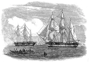
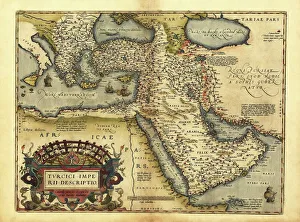
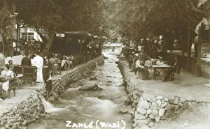
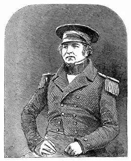
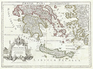
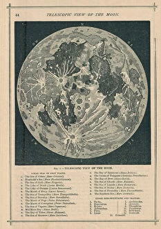
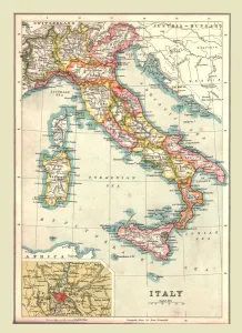
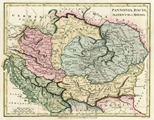
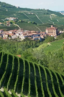
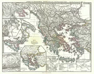
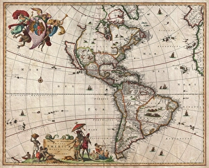
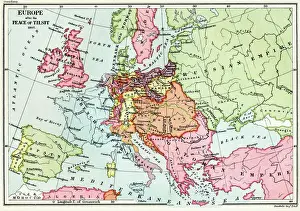
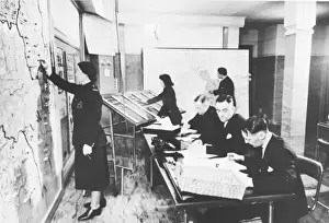
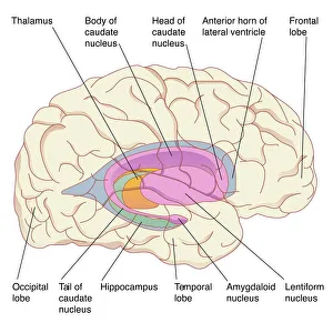
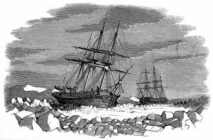
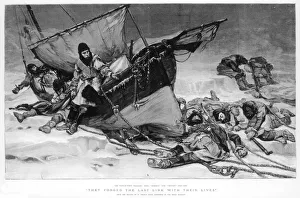
Explore the captivating world of regions through a journey across time and space. Step back to 1845, when the HMS Erebus and HMS Terror set sail on their ill-fated expedition in search of the Northwest Passage. These ships ventured into uncharted territories, braving treacherous waters and unknown lands. Fast forward to 1768, where James Craig's Map of New Town in Edinburgh showcases the birth of a new region. This meticulously crafted plan laid the foundation for an architectural masterpiece that still stands today. Travel eastward to Zahle in Lebanon, a region known for its rich history and vibrant culture. Nestled amidst picturesque landscapes, this enchanting place offers glimpses into ancient civilizations that once thrived here. Meet Captain Francis Crozier of HMS Terror, who fearlessly led his crew through icy Arctic waters. His unwavering determination embodies the spirit of exploration that defines regions yet untouched by human presence. Cast your eyes upon Orteliuss map from 1570, revealing the vast Ottoman Empire at its zenith. This intricate cartographic marvel provides insights into political boundaries and cultural diversity within this expansive region. Delve deeper into our own bodies with an artwork depicting the medulla oblongata in our brain - a vital region responsible for controlling essential functions like breathing and heartbeat. Journey back to ancient Greece with Delisle's Map from 1794, which unveils Southern Ancient Greece along with Greek Isles and Crete. Explore these historic regions teeming with myths, legends, and extraordinary tales waiting to be discovered. Witness London's Bedford Heavy Unit patrolling as part of NFS (London Region) during World War II. In this tumultuous era, regions played crucial roles in defending nations against external threats while fostering unity among communities within their borders. Marvel at an exquisite map showcasing Italy's diverse landscapes created by an unknown artist in 1902. From rolling hills adorned with vineyards to majestic coastlines, this region's beauty is truly unparalleled.