Premium Framed Print > Renaissance art
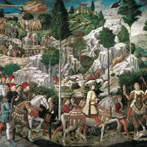
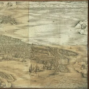
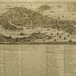
Premium Framed Print : VENICE: MAP, 17TH CENTURY. Map of Venice by Guiseppe Heintz, 17th century


![]()
Framed Photos From Granger
VENICE: MAP, 17TH CENTURY. Map of Venice by Guiseppe Heintz, 17th century
Granger holds millions of images spanning more than 25,000 years of world history, from before the Stone Age to the dawn of the Space Age
Media ID 6617711
17th Century Birds Eye View Blow Canal Fleet Island Lagoon Personification Plan Ship Venetian Venice Wind Guiseppe Heintz
14"x18" Premium Frame
Contemporary style Premium Wooden Frame with 8"x12" Print. Complete with 2" White Mat and 1.25" thick MDF frame. Printed on 260 gsm premium paper. Glazed with shatter proof UV coated acrylic glass. Backing is paper covered backing with rubber bumpers. Supplied ready to hang with a pre-installed sawtooth/wire hanger. Care Instructions: Spot clean with a damp cloth. Securely packaged in a clear plastic bag and envelope in a reinforced cardboard shipper
FSC Real Wood Frame and Double Mounted with White Conservation Mountboard - Professionally Made and Ready to Hang
Estimated Image Size (if not cropped) is 30.4cm x 20.3cm (12" x 8")
Estimated Product Size is 45.8cm x 35.6cm (18" x 14")
These are individually made so all sizes are approximate
Artwork printed orientated as per the preview above, with landscape (horizontal) orientation to match the source image.
FEATURES IN THESE COLLECTIONS
> Arts
> Art Movements
> Renaissance Art
> Maps and Charts
> Related Images
EDITORS COMMENTS
This print takes us back in time to the 17th century, showcasing a meticulously detailed map of Venice by Guiseppe Heintz. The city's intricate network of canals and islands is beautifully depicted, offering a birds-eye view that transports us to this enchanting Renaissance-era metropolis. As we gaze upon the map, we are struck by the skillful personification of Venice herself. The lagoon seems alive with movement as ships gracefully navigate its waters, their sails billowing in the wind. The fleet represents Venetian maritime power and trade dominance during this era. The text accompanying the map provides valuable insights into the layout and planning of Venice at that time. It guides our eyes through winding canals, past stunning architecture and bustling streets filled with life. From a distance, we observe an exterior perspective of Venice's grandeur; its iconic buildings rise majestically from the water's edge. This unique vantage point allows us to appreciate how seamlessly this city merges with its watery surroundings. The carousel collection from which this print originates showcases not only historical significance but also artistic mastery. Every brushstroke captures the essence of Venice's charm and allure. Whether you are an admirer of cartography or simply fascinated by history, this remarkable print offers a glimpse into one of Europe's most captivating cities during its golden age - a true treasure for any art lover or history enthusiast alike.
MADE IN THE USA
Safe Shipping with 30 Day Money Back Guarantee
FREE PERSONALISATION*
We are proud to offer a range of customisation features including Personalised Captions, Color Filters and Picture Zoom Tools
SECURE PAYMENTS
We happily accept a wide range of payment options so you can pay for the things you need in the way that is most convenient for you
* Options may vary by product and licensing agreement. Zoomed Pictures can be adjusted in the Basket.