Fraud Blocker Skip to main content

Island Collection

EDITORS COMMENTS"Exploring the Enchanting World of Islands

Background imageIsland Collection: Sea stacks and cliffs at sunset at Eshaness / Esha Ness, peninsula in Northmavine

Sea stacks and cliffs at sunset at Eshaness / Esha Ness, peninsula in Northmavine on the island of Mainland, Shetland Islands, Scotland, UK, May 2018

Secluded turquoise beach in Aruba, Caribbean Blue sea, Duth Antilles Secluded turquoise beach in idyllic Aruba, Caribbean Blue sea, Duth Antilles

Background imageIsland Collection: Holy Virgin, 12th century Byzantine mosaic

Holy Virgin, 12th century Byzantine mosaic, cathedral of Santa Maria Assunta, Torcello, Venice, Veneto, Italy Holy Virgin, 12th century Byzantine mosaic, cathedral of Santa Maria Assunta, Torcello

Background imageIsland Collection: The Wicker Man (1973) UK One Sheet poster

The Wicker Man (1973) UK One Sheet poster
Original British Lion poster artwork for the release of Robin Hardys The Wicker Man, featuring Christopher Lee and Ed Woodward

Background imageIsland Collection: Pacific-Cook Islands - Rarotonga

Pacific-Cook Islands - Rarotonga
The resort region of Muri on the Eastern side of the Island of Rarotonga, the largest island in the Cook Islands is viewed from the air. AFP PHOTO / Marty Melville / AFP PHOTO / Marty Melville

Background imageIsland Collection: Map of Cyprus, published in 1880

Map of Cyprus, published in 1880
Ancient map of Cyprus. Lithograph, published in 1880

Background imageIsland Collection: Miyajima Island Park, Japan

Miyajima Island Park, Japan Japan Miyajima isle. Date of Photograph:1866-1890

Background imageIsland Collection: Chios or Chio, Greece (engraving, 1588)

Chios or Chio, Greece (engraving, 1588)
LRI4714727 Chios or Chio, Greece (engraving, 1588) by Hogenberg, Franz (1540-c.1590); Private Collection; (add.info.: Chios Maris Aegaei eiusdem nominis Insulae Civitas (Chios or Chio, Greece)

Background imageIsland Collection: Political Map of Africa

Political Map of Africa
Vector Illustration of the policital map of Africa Reference map as created by the US Central Intelligence Agency

Background imageIsland Collection: Vancouver Island map, 1870s

Vancouver Island map, 1870s
Map of Vancouver Island, British Columbia, Canada, 1870s. Lithograph reproduction of a 19th-century illustration

Background imageIsland Collection: Iceland map, 1800s

Iceland map, 1800s
Map of Iceland, 1870s. Printed color lithograph reproduction of a 19th-century illustratioin

Background imageIsland Collection: Paddleship Waverley at Staffa, Scotland

Paddleship Waverley at Staffa, Scotland
The sea-going paddleship " Waverley" at Staffa, Argyll & Bute, Scotland

Background imageIsland Collection: Sicily map 1895

Sicily map 1895
Meyers Konversations-Lexikon. Ein Nachschlagewerk des allgemeinen Wissens, 5th edition 17 volumes Bibliographisches Institut - Leipzig 1895-1897

Background imageIsland Collection: Map of Cyprus

Map of Cyprus
Vintage 19th Century map of Cyprus in the eastern Mediterranean Sea

Background imageIsland Collection: Scotland, Orkney Islands, Skara Brae Prehistoric Village

Scotland, Orkney Islands, Skara Brae Prehistoric Village

Background imageIsland Collection: MAP: JAMAICA, 1893. British map of Jamaica by Colin Liddell, published 1893

MAP: JAMAICA, 1893. British map of Jamaica by Colin Liddell, published 1893

Background imageIsland Collection: MAP: PHILIPPINES, 1905. Map of the Philippine Islands printed in the United States in 1905

MAP: PHILIPPINES, 1905. Map of the Philippine Islands printed in the United States in 1905

Background imageIsland Collection: Deluge scene. Painting by Anne Louis Girodet de Roucy-Trioson (Anne-Louis Girodet de Roucy Trioson)

Deluge scene. Painting by Anne Louis Girodet de Roucy-Trioson (Anne-Louis Girodet de Roucy Trioson)
JLJ4690546 Deluge scene. Painting by Anne Louis Girodet de Roucy-Trioson (Anne-Louis Girodet de Roucy Trioson, 1767-1824), 19th century. Oil on canvas. Dim 4, 41 x 3, 41m

Background imageIsland Collection: Map of Portugal

Map of Portugal
Antique illustration engraving map og Portugal

Background imageIsland Collection: Tresco 29035_031

Tresco 29035_031
Tresco, Isles of Scilly. SV8914/60

Background imageIsland Collection: Newfoundland, 1870s

Newfoundland, 1870s
Map of Newfoundland, Canada, 1870s. Printed color lithograph

Background imageIsland Collection: British Isles, satellite image

British Isles, satellite image
UK and Ireland. Satellite image of the UK and the Republic of Ireland (Eire). North is at top. Water is blue, vegetation is green, dry or barren areas are brown, and snow and ice are white

Background imageIsland Collection: The Neck of Bruny Island, South Eastern Coast of Tasmania, Australia

The Neck of Bruny Island, South Eastern Coast of Tasmania, Australia
Bruny Island is an island off the south-eastern coast of Tasmania, from which it is separated by the D Entrecasteaux Channel

Background imageIsland Collection: SEURAT: GRANDE JATTE, 1886. A Sunday Afternoon on the Island of La Grande Jatte

SEURAT: GRANDE JATTE, 1886. A Sunday Afternoon on the Island of La Grande Jatte. Oil on canvas by Georges Seurat, 1884-86

Background imageIsland Collection: The island of Hirta, St Kilda, Scotland

The island of Hirta, St Kilda, Scotland
The ruins of the abandoned village on the Atlantic island of Hirta, the largest of the islands in St Kilda, Western Isles, Scotland. In the background are the stone cleits which were used for storage

Background imageIsland Collection: MAP: HAWAII, 1905. Map of the Hawaiian Islands printed in the United States in 1905

MAP: HAWAII, 1905. Map of the Hawaiian Islands printed in the United States in 1905

Background imageIsland Collection: UK at night from space

UK at night from space
UK at night, as seen from the International Space Station (ISS). City lights (yellow) show areas of dense population. France is at bottom. Image taken on 24th December 2010

Background imageIsland Collection: Mephisto Cigars label, printed by F. Heppenheimers sons, New York

Mephisto Cigars label, printed by F. Heppenheimers sons, New York
PNP382187 Mephisto Cigars label, printed by F. Heppenheimers sons, New York, 1897 (colour litho) by American School, (19th century); Private Collection; (add.info.: Manufactured bu D)

Background imageIsland Collection: Maltese islands map 1883

Maltese islands map 1883
Encyclopedia Britannica 9th Edition New York Samuel L. Hall 1883 Vol XV

Background imageIsland Collection: Art Deco Burgh Island Hotel

Art Deco Burgh Island Hotel
Burgh Island is a small tidal island on the coast of South Devon. There are several buildings on the island, the largest being the Art Deco Burgh Island Hotel

Background imageIsland Collection: Bryher 29035_029

Bryher 29035_029
Bryher, Isles of Scilly. SV8714/27

Background imageIsland Collection: MAP: CUBA, 1900. Map of Cuba printed in the United States, c1900

MAP: CUBA, 1900. Map of Cuba printed in the United States, c1900

Background imageIsland Collection: Captain Cook killed by Hawaiian natives, 1779

Captain Cook killed by Hawaiian natives, 1779
Death of English explorer Captain James Cook in the Sandwich Islands (Hawaii), 1779. Hand-colored woodcut reproduction of a painting

Background imageIsland Collection: Tenerife, satellite image

Tenerife, satellite image. Satellite image of Tenerife showing Mount Teide (lower centre). Vegetation is green, and water is blue

Background imageIsland Collection: Haiti and Dominican republic map 1883

Haiti and Dominican republic map 1883
Encyclopedia Britannica 9th Edition New York Samuel L. Hall 1883 Vol XI

Background imageIsland Collection: Milky Way behind tree, South Island, New Zealand

Milky Way behind tree, South Island, New Zealand
Milky Way over New Zealands Southern Alps at Mount Cook National Park

Background imageIsland Collection: Holiday resort with overwater bungalows, Bora Bora, French Polynesia

Holiday resort with overwater bungalows, Bora Bora, French Polynesia

Background imageIsland Collection: Rottnest Island Holidays

Rottnest Island Holidays. A beautiful island just off the coast of Perth is a popular tourist attraction filled with magnificent views, water activities, and accommodation

Background imageIsland Collection: Platos map of Atlantis, artwork

Platos map of Atlantis, artwork. Artwork of the mythological city of Atlantis, as described by the Ancient Greek philosopher Plato. Plato made the first written references to Atlantis in 360 BC

Background imageIsland Collection: Stromness, Orkney, Scotland

Stromness, Orkney, Scotland
The village of Stromness in Orkney, Scotland

Background imageIsland Collection: Map of the Pacific island groups, 1800s

Map of the Pacific island groups, 1800s. Hand-colored woodcut of a 19th-century illustration

Background imageIsland Collection: Map of Hawaii, 1870s

Map of Hawaii, 1870s
Map of the Hawaiian islands, 1870s. Color lithograph reproduction of a 19th-century illustration

Background imageIsland Collection: Political map of The Middle East

Political map of The Middle East
Vector illustration of the policital map of The Middle East Reference map was created by the US Central Intelligence Agency

Background imageIsland Collection: Map of the Scilly Isles

Map of the Scilly Isles
Vintage map from 1880 of the Scilly Isles an archipelago off the southwestern tip of the Cornish peninsula of Great Britain

Background imageIsland Collection: Map of Japan in Provinces in time of Iyeyasu, 1903. Creator: Unknown

Map of Japan in Provinces in time of Iyeyasu, 1903. Creator: Unknown
Map of Japan in Provinces in time of Iyeyasu, 1903. Tokugawa Ieyasu (1543-1616) first shogun of the Tokugawa shogunate which ruled Japan from 1600-1868 and is known as the Edo period

Background imageIsland Collection: Map of Saint Lucia, 19th Century

Map of Saint Lucia, 19th Century
Vintage engraving of Map of Saint Lucia, 19th Century

Background imageIsland Collection: View over the old town of Corfu, Greece

View over the old town of Corfu, Greece
Viewof bell-tower, church of Agios Spyridon prominent, Corfu Town, Corfu, Ionian Islands, Greece. The Old Town of Corfu was added to the UNESCO World Heritage List in 2007

Background imageIsland Collection: St Agnes 29034_032

St Agnes 29034_032
St. Agnes, Isles of Scilly, looking NE towards St. Mary s). SV8807/37

Background imageIsland Collection: VENICE: MAP, 17TH CENTURY. Map of Venice by Guiseppe Heintz, 17th century

VENICE: MAP, 17TH CENTURY. Map of Venice by Guiseppe Heintz, 17th century

Background imageIsland Collection: True-colour satellite image of northwest Scotland

True-colour satellite image of northwest Scotland

Background imageIsland Collection: Isola Bella in Lago Maggiore, 1871. Creator: Sanford Robinson Gifford

Isola Bella in Lago Maggiore, 1871. Creator: Sanford Robinson Gifford
Isola Bella in Lago Maggiore, 1871

Background imageIsland Collection: Napoleon, (1769-1821), c1894-95, (1936). Creator: James Sant

Napoleon, (1769-1821), c1894-95, (1936). Creator: James Sant
Napoleon, (1769-1821), c1894-95, (1936)

Background imageIsland Collection: Islands of Boreray and Stac Lee, St Kilda, Outer Hebrides, Scotland, UK, July 2015

Islands of Boreray and Stac Lee, St Kilda, Outer Hebrides, Scotland, UK, July 2015

Background imageIsland Collection: Vancouver island map 1885

Vancouver island map 1885
Encyclopedia Britannica 9th Edition New York Charles Scribners and Sons 1885 Vol XXIV

Background imageIsland Collection: Griffiths Island lighthouse

Griffiths Island lighthouse, port fairy, Victoria, Australia

Background imageIsland Collection: Colossus Of Rhodes

Colossus Of Rhodes
The Colossus of Rhodes, a giant statue of the sun god Helios measuring 34 metres, towers over the islands harbour, circa 250 BC

Background imageIsland Collection: Steep Holm JEH_22025_06

Steep Holm JEH_22025_06
Steep Holm, Bristol Channel. Steep Holme is a small island in the Bristol Channel, five miles off Weston-super-Mare. Despite this, it was settled throughout history

Background imageIsland Collection: A view of Loch Torridon, Scotland

A view of Loch Torridon, Scotland
A view of Loch Torridon and the Torridon hills from near Shieldaig in Ross & Cromarty, Highland region, Scotland

Background imageIsland Collection: The island of Iona, Scotland

The island of Iona, Scotland
The island of Iona, off the coast of Mull, Argyll, Scotland, showing Iona Abbey and the village

Background imageIsland Collection: Cartouche on W. Mayos Map of Barbados, 1722, (1944). Creator: William Mayo

Cartouche on W. Mayos Map of Barbados, 1722, (1944). Creator: William Mayo
Cartouche on W. Mayos Map of Barbados, 1722, (1944). A New & Exact Map of the Island of Barbadoes in America. According to an Actual & Accurate Survey

Background imageIsland Collection: Alcatraz Island and Prison in San Franciso, California, USA

Alcatraz Island and Prison in San Franciso, California, USA

Background imageIsland Collection: Map of the Caribbean island of Martinique, c1783

Map of the Caribbean island of Martinique, c1783

Background imageIsland Collection: Madeira island map 1883

Madeira island map 1883
Encyclopedia Britannica 9th Edition New York Samuel L. Hall 1883 Vol XV

Background imageIsland Collection: Map of Capri, Italian island, wood engraving published in 1897

Map of Capri, Italian island, wood engraving published in 1897
Map of Capri, Italian island. Wood engraving, published in 1897

Background imageIsland Collection: Daniel Osterkamp, Lofoten, Mountain, Mountains, Norway, Panorama, Water, arctic, boat

Daniel Osterkamp, Lofoten, Mountain, Mountains, Norway, Panorama, Water, arctic, boat
This picture shows the city of Reine at the Lofoten in Norway

Background imageIsland Collection: Map of the Netherlands, lithograph, published in 1877

Map of the Netherlands, lithograph, published in 1877
Map of the Netherlands. Lithograph, published in 1877

Background imageIsland Collection: Map of Panama 1864

Map of Panama 1864
Map of Panama - combined with 2 different texture overlays

Background imageIsland Collection: North Stradbroke Island

North Stradbroke Island
Aerial view of Point Lookout and Cylinder Beach on Stradbroke Island

Background imageIsland Collection: Cape Romano sunken domes

Cape Romano sunken domes
sunrise over the sunken domes of Cape Romano. Once a vacation residence but two Hurricanes destroyed the island and so these abandoned buildings slowly wandered into the Gulf of Mexico

Background imageIsland Collection: Map of Bermuda (colour engraving)

Map of Bermuda (colour engraving)
XCF285171 Map of Bermuda (colour engraving) by English School; Private Collection; English, out of copyright

Background imageIsland Collection: Sunset at Almyros Beach, near Acharavi

Sunset at Almyros Beach, near Acharavi, north coast, Corfu Island, Ionian Islands, Greece, Southern Europe, Europe

Background imageIsland Collection: Stormy weather, King Island, Bass Strait, Tasmania, Australia

Stormy weather, King Island, Bass Strait, Tasmania, Australia

Background imageIsland Collection: Church Sheep

Church Sheep
6th August 1955: Sheep huddle in the doorway of the Abbey on the tiny island of Iona, famous for its connection with St Columba who founded a community on Iona after he was expelled from Ireland

Background imageIsland Collection: Lighthouse

Lighthouse
A lighthouse on Rottnest Island, Perth, Australia

Background imageIsland Collection: Map of Sicily, by Willem Blaeu, from Regionum Italiae, engraving

Map of Sicily, by Willem Blaeu, from Regionum Italiae, engraving
Cartography, Italy, 17th century. Map of Sicily. From Regionum Italiae, by Willem Blaeu. Engraving

Background imageIsland Collection: Scotland, UK, satellite image

Scotland, UK, satellite image
Scotland, UK. North is at top. Natural colour satellite image showing Scotland in the United Kingdom, with the surrounding territories shaded out

Background imageIsland Collection: The view to Rum from Arisaig, Scotland

The view to Rum from Arisaig, Scotland
The view to the island of Rum from Arisaig in Lochaber, Highland Region, Scotland

Background imageIsland Collection: CARIBBEAN MAP. A map of the Caribbean islands: woodcut, French, c. 1688

CARIBBEAN MAP. A map of the Caribbean islands: woodcut, French, c. 1688

Background imageIsland Collection: Lobster boat off the Atlantic coast of Maine and Canada

Lobster boat off the Atlantic coast of Maine and Canada
Lobster fishermen in the Grand Manan Channel between Maine and New Brunswick, 1890s. Hand-colored halftone reproduction of a 19th-century illustration

Background imageIsland Collection: Iceland

Iceland, satellite image. Located in the Atlantic Ocean, just below the Arctic Circle, Iceland is a sparsely populated country of around 300, 000 people and an area of 100, 000 square kilometres

Background imageIsland Collection: Scots pine (Pinus sylvestris) trees reflected in Loch Maree at sunrise with Slioch in background

Scots pine (Pinus sylvestris) trees reflected in Loch Maree at sunrise with Slioch in background, Wester Ross, Scotland, UK, November 2014


All products are expertly crafted, using premium materials, tailored to your specifications and promptly shipped


EDITORS COMMENTS

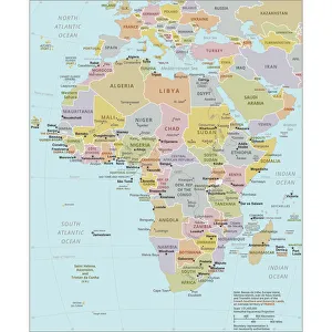
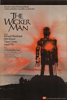
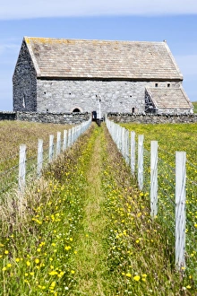
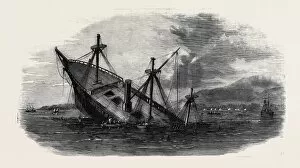
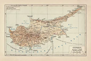
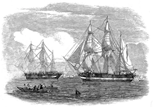
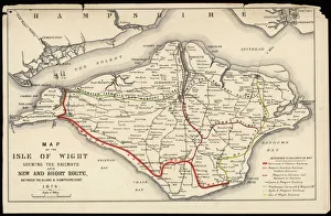
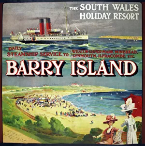
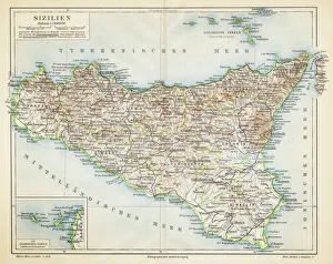
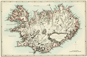
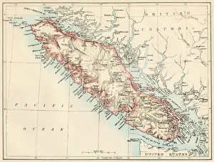
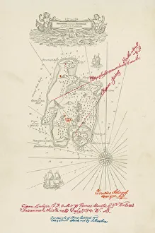
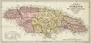
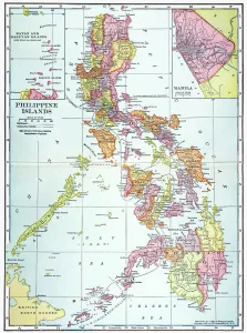
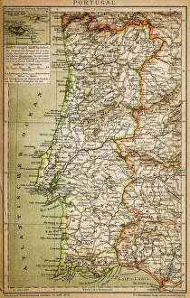
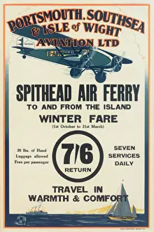
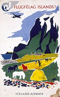
"Exploring the Enchanting World of Islands: From Ancient Maps to Exotic Destinations" Delve into the mysterious allure of islands with "The Wicker Man (1973) UK One Sheet poster, " a cinematic masterpiece that transports you to an isolated land filled with secrets and suspense. Uncover the chilling tale of HMS Erebus and HMS Terror, 1845, as these ill-fated ships embarked on a treacherous Arctic expedition, forever etching their names in history. Journey back in time with a Map of Cyprus published in 1880, tracing the island's rich heritage and cultural tapestry that has captivated explorers for centuries. Marvel at the vastness and diversity of Africa through a Political Map of Africa, showcasing its vibrant nations and breathtaking landscapes that make it one of Earth's most captivating continents. Escape to Barry Island through an enticing poster, promising sun-soaked beaches and endless fun amidst this beloved British seaside destination cherished by generations. Immerse yourself in Iceland's fascinating past with an Iceland map from the 1800s, where rugged terrains meet ethereal beauty, inviting adventurers to explore its otherworldly wonders. Discover the charm of Isle of Wight through a meticulously detailed map capturing its idyllic villages, rolling hillsides, and picturesque coastlines that have made it a favorite among travelers worldwide. Embark on an aviation adventure across Portsmouth, Southsea & Isle of Wight with an enchanting vintage poster depicting soaring planes against azure skies—a testament to humanity's desire for exploration even beyond islands' shores. Traverse Vancouver Island through a mesmerizing map from the 1870s—unravel hidden treasures within dense forests or embark on thrilling coastal escapades along Canada's western gemstone. Lose yourself in Portugal’s rich history as you navigate its diverse regions using a captivating map, unveiling the country's enchanting landscapes and architectural wonders.

© Copyright Media Storehouse, All Rights Reserved 2003 - 2025
Facebook     Pinterest     100% Payment Secure     Reviews IO