Photographic Print > Arts > Artists > H > Thomas Hand
Photographic Print : Virginia map, 1588


![]()
Photo Prints From North Wind
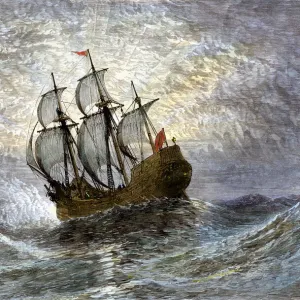
Virginia map, 1588
Thomas Harriots map of Virginia, 1588.
Hand-colored 19th-century woodcut reproduction of a document
North Wind Picture Archives brings history to life with stock images and hand-colored illustrations
Media ID 5882505
© North Wind Picture Archives
1500s 1588 16th Century Amerindian Atlantic Atlantic Coast Colonial Colony Compass Document English English Colony Indian James River Native Native American Outer Banks Powhatan Raleighs Colony Roanoke Island Sailing Ship Ship South Southern Virginia Whale Calipers Croatoan Harriot Secotan
10"x8" Photo Print
Step back in time with our exquisite selection from the Media Storehouse range of Historical Photographic Prints. This captivating piece features a hand-colored 19th-century woodcut reproduction of Thomas Harriot's map of Virginia, originally published in 1588. Meticulously sourced from the North Wind Picture Archives, this vintage print offers a unique glimpse into the past, showcasing intricate details of the early exploration of the New World. Ideal for history enthusiasts, educators, or anyone seeking to add a touch of antiquity to their home or office decor. Bring the past to life with Media Storehouse's Historical Photographic Prints.
Photo prints are produced on Kodak professional photo paper resulting in timeless and breath-taking prints which are also ideal for framing. The colors produced are rich and vivid, with accurate blacks and pristine whites, resulting in prints that are truly timeless and magnificent. Whether you're looking to display your prints in your home, office, or gallery, our range of photographic prints are sure to impress. Dimensions refers to the size of the paper in inches.
Our Photo Prints are in a large range of sizes and are printed on Archival Quality Paper for excellent colour reproduction and longevity. They are ideal for framing (our Framed Prints use these) at a reasonable cost. Alternatives include cheaper Poster Prints and higher quality Fine Art Paper, the choice of which is largely dependant on your budget.
Estimated Image Size (if not cropped) is 25.4cm x 18.6cm (10" x 7.3")
Estimated Product Size is 25.4cm x 20.3cm (10" x 8")
These are individually made so all sizes are approximate
Artwork printed orientated as per the preview above, with landscape (horizontal) orientation to match the source image.
FEATURES IN THESE COLLECTIONS
> North Wind Picture Archives
> Maps
> Arts
> Artists
> H
> Thomas Hand
> Arts
> Artists
> N
> Thomas North
> Arts
> Landscape paintings
> Waterfall and river artworks
> River artworks
> Historic
> Colonial America illustrations
> Colonial America
> Historic
> Colonial America illustrations
> Historic
> Colonial history
> Colonial art and artists
> Popular Themes
> North Island
> South America
> Related Images
EDITORS COMMENTS
This print showcases a hand-colored 19th-century woodcut reproduction of Thomas Harriot's map of Virginia from the year 1588. Steeped in history, this vintage document provides a fascinating glimpse into the early days of American exploration and colonization. The intricate illustration depicts an English sailing ship gracefully navigating the Atlantic coast, symbolizing the brave journeys undertaken by settlers during that era. The map encompasses various significant landmarks such as the James River, Roanoke Island (home to Raleigh's colony), and Outer Banks. It also highlights indigenous Amerindian tribes like Powhatan and Secotan, reminding us of their rich heritage intertwined with this colonial narrative. With its meticulous details and delicate artistry, this map offers a visual time capsule capturing the essence of 16th-century Virginia. The compass elegantly points towards uncharted territories while calipers delicately measure distances on this historical piece. As we gaze upon this remarkable artifact, we are transported back in time to witness America's early beginnings unfold before our eyes. This image serves as a reminder of our nation's complex past and invites us to explore how these events have shaped our present-day United States.
MADE IN THE USA
Safe Shipping with 30 Day Money Back Guarantee
FREE PERSONALISATION*
We are proud to offer a range of customisation features including Personalised Captions, Color Filters and Picture Zoom Tools
SECURE PAYMENTS
We happily accept a wide range of payment options so you can pay for the things you need in the way that is most convenient for you
* Options may vary by product and licensing agreement. Zoomed Pictures can be adjusted in the Basket.