mail_outline sales@mediastorehouse.com
Framed Print
Premium Framed Print
Canvas Print
Metal Print
Photographic Print
Poster Print
Fine Art Print
Jigsaw Puzzle
Photo Mug
Pillow
Mouse Mat
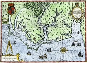
The Englishmen's Arrival in Virginia: Map of Virginia coast showing Native territories Secotan and Weapemoc528106 The Englishmen's Arrival in Virginia: Map of Virginia coast showing Native territories Secotan and Weapemoc, and the Native community on Roanoak island at river mouth, 1590
Map of 1590 engraved by Theodore de Bry after watercolour by the English colonist John White, governor of Roanoke528389 Map of 1590 engraved by Theodore de Bry after watercolour by the English colonist John White, governor of Roanoke. Virginia and coast with small islands and Roanoke at mouth of river
Virginia map, 1588Thomas Harriots map of Virginia, 1588. Hand-colored 19th-century woodcut reproduction of a document
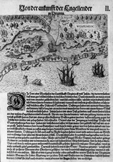
The Arrival of the English in Virginia, from Admiranda Narratio 1585-88XIR190220 The Arrival of the English in Virginia, from Admiranda Narratio.. 1585-88 (coloured engraving) by Bry, Theodore de (1528-98); Service Historique de la Marine, Vincennes
Map of 1590 engraved by Theodore de Bry after watercolour by the English colonist John White, governor of Roanoke. Virginia and coast with small islands and Roanoke at mouth of river
The Englishmans Arrival in Virginia: 1590. Th. De Bry after watercolour by John White English colonist, governor of Roanoke. Virginia coast with small islands and Roanoke at mouth of river
The Englishmens Arrival in Virginia: Map of Virginia coast showing Native territories Secotan and Weapemoc, and the Native community on Roanoak island at river mouth, 1590
NATI2A-00032Native American village and gardens of Secotan, North Carolina, then in Virginia Colony, 1600s. Hand-colored woodcut of a John White illustration
NATI2A-00087Native American way of cooking fish, Virginia Colony, 1585. Hand-colored woodcut reproducgtion of a John White illustration
Secotan Village 1585SECOTAN village, Carolina