Home > Maps and Charts > British Empire Maps
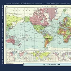
A 1930s Map Of The World On Mercators Projection. The British Empire Shown In Red

![]()
Wall Art and Photo Gifts from Design Pics
A 1930s Map Of The World On Mercators Projection. The British Empire Shown In Red
Design Pics offers Distinctively Different Imagery representing over 1,500 contributors
Media ID 18176894
© Hilary Jane Morgan / Design Pics
1930s 20th Countries Empire Geographical Geography Nineteen Projection Thirties Twentieth World Mercator
FEATURES IN THESE COLLECTIONS
> Design Pics
> Design Pics Art
> Art llustrations and Engravings
> Maps and Charts
> British Empire Maps
> Maps and Charts
> Early Maps
> Maps and Charts
> Related Images
> Maps and Charts
> World
EDITORS COMMENTS
This print by Hilary Jane Morgan takes us back to the 1930s, showcasing a map of the world on Mercator's projection. The intricate illustration captures the geopolitical landscape of that era, with particular emphasis on the British Empire depicted in vibrant red. The map serves as a fascinating historical artifact, providing insights into the global dominance and influence of the British Empire during the twentieth century. It offers a visual representation of how this empire spanned across continents and encompassed numerous countries under its rule. Morgan's attention to detail is evident in this stunning piece. Every country is meticulously outlined, allowing viewers to explore and appreciate the geographical diversity present on our planet at that time. The use of Mercator's projection adds an interesting perspective, offering a unique way to interpret spatial relationships between different regions. As we gaze upon this remarkable print, we are transported back in time – reminded of an era marked by significant political shifts and historical events. This artwork not only celebrates cartography but also invites us to reflect upon our shared human history and how it has shaped our present-day world. Whether you have a passion for geography or simply appreciate art that tells stories from another time, "A 1930s Map Of The World On Mercators Projection" will undoubtedly captivate your imagination and ignite curiosity about our past.
MADE IN THE USA
Safe Shipping with 30 Day Money Back Guarantee
FREE PERSONALISATION*
We are proud to offer a range of customisation features including Personalised Captions, Color Filters and Picture Zoom Tools
SECURE PAYMENTS
We happily accept a wide range of payment options so you can pay for the things you need in the way that is most convenient for you
* Options may vary by product and licensing agreement. Zoomed Pictures can be adjusted in the Cart.