Fraud Blocker Skip to main content

Home > Arts > Artists > B > Willem Blaeu

Willem Blaeu Collection (page 2)

Willem Blaeu (1571-1638) was a Dutch cartographer, publisher, and globe maker

206 items

Background imageWillem Blaeu Collection: Map of Europe from the Blaeu Atlas, 17th century, 1622-25 (print)

Map of Europe from the Blaeu Atlas, 17th century, 1622-25 (print)
7339183 Map of Europe from the Blaeu Atlas, 17th century, 1622-25 (print) by Blaeu, Joan (1596-1673); National Maritime Museum, London

Background imageWillem Blaeu Collection: World map from the Blaeu Atlas, 17th century, c.1662 (print)

World map from the Blaeu Atlas, 17th century, c.1662 (print)
7339181 World map from the Blaeu Atlas, 17th century, c.1662 (print) by Blaeu, Joan (1596-1673); National Maritime Museum, London, UK; (add.info.: Creator: John Blaeu World map from Bleau Atlas)

Background imageWillem Blaeu Collection: Geography: Earth globe realized by cartographer Willem Janszoon Blaeu (1571-1638)

Geography: Earth globe realized by cartographer Willem Janszoon Blaeu (1571-1638)
VEN5030415 Geography: Earth globe realized by cartographer Willem Janszoon Blaeu (1571-1638). Debut of the 17th century Biblioteca Angelica

Background imageWillem Blaeu Collection: Geography: detail of a globe by cartographer Willem Janszoon Blaeu (1571-1638)

Geography: detail of a globe by cartographer Willem Janszoon Blaeu (1571-1638)
VEN5030414 Geography: detail of a globe by cartographer Willem Janszoon Blaeu (1571-1638). Debut of the 17th century Biblioteca Angelica

Background imageWillem Blaeu Collection: Geography map: representation of part of the territories of New Spain (Florida, Mexico)

Geography map: representation of part of the territories of New Spain (Florida, Mexico)
VEN5030337 Geography map: representation of part of the territories of New Spain (Florida, Mexico, Central America) and taken from an Atlas by Willem Janszoon Blaeu (1571-1638), approximately 1630

Background imageWillem Blaeu Collection: Geography map: representation of the state of Penambuco in northern Brazil in South America

Geography map: representation of the state of Penambuco in northern Brazil in South America from an Atlas made by
VEN5030370 Geography map: representation of the state of Penambuco in northern Brazil in South America from an Atlas made by cartographer Willem Janszoon Blaeu (1571-1638)

Background imageWillem Blaeu Collection: Map of the surroundings of Zandvliet, 1642. Creator: Willem Blaeu

Map of the surroundings of Zandvliet, 1642. Creator: Willem Blaeu
Map of the surroundings of Zandvliet, 1642. The north on the left, the borders coloured, cities, buildings and flags indicated. At the top left Explanation of the symbols on the map

Background imageWillem Blaeu Collection: Map of Brabant, 1631. Creator: Willem Blaeu

Map of Brabant, 1631. Creator: Willem Blaeu
Map of Brabant, 1631. Map of the Duchy of Brabant. At the bottom right the scale in German miles. Bottom left the title between sphinxes, above it the coat of arms and woman with staff

Background imageWillem Blaeu Collection: Map of the Strait of Magellan, 1635-1664. Creator: Willem Blaeu

Map of the Strait of Magellan, 1635-1664. Creator: Willem Blaeu
Map of the Strait of Magellan, 1635-1664. At the top right a coat of arms

Background imageWillem Blaeu Collection: Map of Brabant, 1635. Creator: Michael van Langren

Map of Brabant, 1635. Creator: Michael van Langren
Map of Brabant, 1635. Prima pars Brabantiae cuius caput Lovanivm'. Top right: a coat of arms; bottom right: title in a cartouche with King David playing the harp

Background imageWillem Blaeu Collection: Map of the area between Bergen op Zoom and Steenbergen, 1630. Creator: Franciscus van Schooten

Map of the area between Bergen op Zoom and Steenbergen, 1630. Creator: Franciscus van Schooten
Map of the area between Bergen op Zoom and Steenbergen, 1630. Tabula Bergarum ad Zomam Stenbergae'. Showing fortresses, trees, hills, harbours, areas susceptible to flooding

Background imageWillem Blaeu Collection: Old Map of England 1635 by Willem & Johan Blaeu from the Theatrum Orbis Terrarum

Old Map of England 1635 by Willem & Johan Blaeu from the Theatrum Orbis Terrarum
This detailed and most attractive reproduction map of England has been carefully art worked from a scan of an antique original

Background imageWillem Blaeu Collection: Old Map of The British Isles 1635 by Willem & Johan Blaeu from the Theatrum Orbis Terrarum

Old Map of The British Isles 1635 by Willem & Johan Blaeu from the Theatrum Orbis Terrarum
This detailed and most attractive reproduction map of The British Isles has been carefully art worked from a scan of an antique original

Background imageWillem Blaeu Collection: Old Map of Lothian - Scottish Lowlands by Johan Blaeu from the Atlas Novus

Old Map of Lothian - Scottish Lowlands by Johan Blaeu from the Atlas Novus
This detailed and most attractive reproduction map of the Scottish Lowlands, known as Lothian, has been carefully art worked from a scan of an antique original

Background imageWillem Blaeu Collection: Old County Map of Kent 1648 by Johan Blaeu from the Atlas Novus

Old County Map of Kent 1648 by Johan Blaeu from the Atlas Novus
This detailed and most attractive reproduction map of Kent has been carefully art worked from a scan of an antique original

Background imageWillem Blaeu Collection: Old Map of Northern Scotland 1654 by Johan Blaeu from the Atlas Novus

Old Map of Northern Scotland 1654 by Johan Blaeu from the Atlas Novus
This detailed and most attractive reproduction map of Northern Scotland has been carefully art worked from a scan of an antique original

Background imageWillem Blaeu Collection: Old Map of Ireland 1635 by Willem & Johan Blaeu from the Theatrum Orbis Terrarum

Old Map of Ireland 1635 by Willem & Johan Blaeu from the Theatrum Orbis Terrarum
This detailed and most attractive reproduction map of Ireland has been carefully art worked from a scan of an antique original

Background imageWillem Blaeu Collection: Old Map of The Americas 1635 by Willem & Johan Blaue from the Theatrum Orbis Terrarum

Old Map of The Americas 1635 by Willem & Johan Blaue from the Theatrum Orbis Terrarum
This detailed and most attractive reproduction map of The Americas has been carefully art worked from a scan of an antique original

Background imageWillem Blaeu Collection: Old Map of The West Indies 1662 by Willem & Johan Blaue from the Theatrum Orbis Terrarum

Old Map of The West Indies 1662 by Willem & Johan Blaue from the Theatrum Orbis Terrarum
This detailed and most attractive reproduction map of The West Indies has been carefully art worked from a scan of an antique original

Background imageWillem Blaeu Collection: Old Map of The Island of Bermuda 1635 by Willem & Johan Blaue from the Theatrum Orbis Terrarum

Old Map of The Island of Bermuda 1635 by Willem & Johan Blaue from the Theatrum Orbis Terrarum
This detailed and most attractive reproduction map of The Island of Bermuda has been carefully art worked from a scan of an antique original

Background imageWillem Blaeu Collection: Old County Map of Sussex 1648 by Johan Blaeu from the Atlas Novus

Old County Map of Sussex 1648 by Johan Blaeu from the Atlas Novus
This detailed and most attractive reproduction map of Sussex has been carefully art worked from a scan of an antique original

Background imageWillem Blaeu Collection: Map of Valois, 1926 (print)

Map of Valois, 1926 (print)
3786712 Map of Valois, 1926 (print) by Blaeu, Willem (1571-1638) and Joan (1596-1673); Private Collection; (add.info.: by Willem and Joan Blaeu)

Background imageWillem Blaeu Collection: Old County Map of Buckinghamshire 1648 by Johan Blaeu from the Atlas Novus

Old County Map of Buckinghamshire 1648 by Johan Blaeu from the Atlas Novus
This detailed and most attractive reproduction map of Buckinghamshire has been carefully art worked from a scan of an antique original

Background imageWillem Blaeu Collection: Old County Map of Bedfordshire 1648 by Johan Blaeu from the Atlas Novus

Old County Map of Bedfordshire 1648 by Johan Blaeu from the Atlas Novus
This detailed and most attractive reproduction map of Bedfordshire has been carefully art worked from a scan of an antique original

Background imageWillem Blaeu Collection: Old County Map of Cambridgeshire 1648 by Johan Blaeu from the Atlas Novus

Old County Map of Cambridgeshire 1648 by Johan Blaeu from the Atlas Novus
This detailed and most attractive reproduction map of Cambridgeshire has been carefully art worked from a scan of an antique original

Background imageWillem Blaeu Collection: Old County Map of Sterlingshire 1654 by Johan Blaue from the Atlas Novus

Old County Map of Sterlingshire 1654 by Johan Blaue from the Atlas Novus
This detailed and most attractive reproduction map of Sterlingshire, Scotland, has been carefully art worked from a scan of an antique original

Background imageWillem Blaeu Collection: Old Map of Teviotdale Scotland 1654 from the Atlas Novus

Old Map of Teviotdale Scotland 1654 from the Atlas Novus
This detailed and most attractive reproduction map of Teviotdale, Scotland, has been carefully art worked from a scan of an antique original

Background imageWillem Blaeu Collection: Old County Map of Oxfordshire 1648 by Johan Blaeu from the Atlas Novus

Old County Map of Oxfordshire 1648 by Johan Blaeu from the Atlas Novus
This detailed and most attractive reproduction map of Oxfordshire has been carefully art worked from a scan of an antique original

Background imageWillem Blaeu Collection: Old County Map of Durham 1648 by Johan Blaeu from the Atlas Novus

Old County Map of Durham 1648 by Johan Blaeu from the Atlas Novus
This detailed and most attractive reproduction map of Durham has been carefully art worked from a scan of an antique original

Background imageWillem Blaeu Collection: Old County Map of Yorkshire 1648 by Johan Blaeu from the Atlas Novus

Old County Map of Yorkshire 1648 by Johan Blaeu from the Atlas Novus
This detailed and most attractive reproduction map of Yorkshire has been carefully art worked from a scan of an antique original

Background imageWillem Blaeu Collection: Old County Map of Inverness-shire 1654 by Johan Blaeu from the Atlas Novus

Old County Map of Inverness-shire 1654 by Johan Blaeu from the Atlas Novus
This detailed and most attractive reproduction map of Inverness-shire has been carefully art worked from a scan of an antique original

Background imageWillem Blaeu Collection: Old County Map of Lancashire 1648 by Johan Blaeu from the Atlas Novus

Old County Map of Lancashire 1648 by Johan Blaeu from the Atlas Novus
This detailed and most attractive reproduction map of Lancashire has been carefully art worked from a scan of an antique original

Background imageWillem Blaeu Collection: Old County Map of Derbyshire 1648 by Johan Blaeu from the Atlas Novus

Old County Map of Derbyshire 1648 by Johan Blaeu from the Atlas Novus
This detailed and most attractive reproduction map of Derbyshire has been carefully art worked from a scan of an antique original

Background imageWillem Blaeu Collection: Old County Map of Cornwall 1648 by Johan Blaeu from the Atlas Novus

Old County Map of Cornwall 1648 by Johan Blaeu from the Atlas Novus
This detailed and most attractive reproduction map of Cornwall has been carefully art worked from a scan of an antique original

Background imageWillem Blaeu Collection: Old County Map of Essex 1648 by Johan Blaeu from the Atlas Novus

Old County Map of Essex 1648 by Johan Blaeu from the Atlas Novus
This detailed and most attractive reproduction map of Essex has been carefully art worked from a scan of an antique original

Background imageWillem Blaeu Collection: Old County Map of Hampshire 1648 by Johan Blaeu from the Atlas Novus

Old County Map of Hampshire 1648 by Johan Blaeu from the Atlas Novus
This detailed and most attractive reproduction map of Hampshire has been carefully art worked from a scan of an antique original

Background imageWillem Blaeu Collection: Old County Map of Aberdeen and Banff 1654 by Johan Blaeu from the Atlas Novus

Old County Map of Aberdeen and Banff 1654 by Johan Blaeu from the Atlas Novus
This detailed and most attractive reproduction map of Aberdeen and Banff has been carefully art worked from a scan of an antique original

Background imageWillem Blaeu Collection: Old County Map of Suffolk 1648 by Johan Blaeu from the Atlas Novus

Old County Map of Suffolk 1648 by Johan Blaeu from the Atlas Novus
This detailed and most attractive reproduction map of Suffolk has been carefully art worked from a scan of an antique original

Background imageWillem Blaeu Collection: Old County Map of Middlesex 1648 by Johan Blaue from the Atlas Novus

Old County Map of Middlesex 1648 by Johan Blaue from the Atlas Novus
This detailed and most attractive reproduction map of Middlesex has been carefully art worked from a scan of an antique original

Background imageWillem Blaeu Collection: Old County Map of Nottinghamshire 1648 by Johan Blaeu from the Atlas Novus

Old County Map of Nottinghamshire 1648 by Johan Blaeu from the Atlas Novus
This detailed and most attractive reproduction map of Nottinghamshire has been carefully art worked from a scan of an antique original

Background imageWillem Blaeu Collection: Map of Groningen, Netherlands, 17th century

Map of Groningen, Netherlands, 17th century. A map of the Dutch province of Groningen, published by Willem Blaeu after the original design by Barthold Wicheringe

Background imageWillem Blaeu Collection: Mozambique in Africa, 1645 (engraving)

Mozambique in Africa, 1645 (engraving)
AIS5368589 Mozambique in Africa, 1645 (engraving) by Blaeu, Willem (1571-1638); Biblioteca de Catalunya, Barcelona, Spain; (add.info)

Background imageWillem Blaeu Collection: The Moscow Kremlin Map of the 16th century (Castellum Urbis Moskvae), 1597 (w/c & tempera on paper)

The Moscow Kremlin Map of the 16th century (Castellum Urbis Moskvae), 1597 (w/c & tempera on paper)
7305378 The Moscow Kremlin Map of the 16th century (Castellum Urbis Moskvae), 1597 (w/c & tempera on paper) by Blaeu, Willem (1571-1638); Museum of History of Moscow

Background imageWillem Blaeu Collection: Map of Chile, 17th century (litho)

Map of Chile, 17th century (litho)
354835 Map of Chile, 17th century (litho) by Blaeu, Willem (1571-1638) (after); Index Fototeca

Background imageWillem Blaeu Collection: View of Pharos at the mouth of the Nile, famous for its lighthouse built between 300 and 280 BC

View of Pharos at the mouth of the Nile, famous for its lighthouse built between 300 and 280 BC
IND113614 View of Pharos at the mouth of the Nile, famous for its lighthouse built between 300 and 280 BC, from Le Theatre du Monde or Nouvel Atlas, 1645 (engraving) by Blaeu

Background imageWillem Blaeu Collection: Geographic map of America. In 'Le theatre du monde ou le nouvel atlas

Geographic map of America. In "Le theatre du monde ou le nouvel atlas
JLJ4690395 Geographic map of America. In " Le theatre du monde ou le nouvel atlas Amsterdam" produced by Willem Janszoon Blaeu (1571-1638), 1635

Background imageWillem Blaeu Collection: Fire, one of the four elements represented in W. Blaeu

Fire, one of the four elements represented in W. Blaeu
GIA4745038 Fire, one of the four elements represented in W. Blaeus Atlas printed in Amsterdam in 1655. by Blaeu, Willem (1571-1638); Private Collection; (add.info.: The Fire)

Background imageWillem Blaeu Collection: Havana, based on William Blaeus Atlas, 1630

Havana, based on William Blaeus Atlas, 1630
GIA4733986 Havana, based on William Blaeus Atlas, 1630. by Blaeu, Willem (1571-1638); Private Collection; (add.info.: Havana, based on William Blaeus Atlas, 1630.); eGiancarlo Costa; Dutch


All Professionally Made to Order for Quick Shipping


-

Willem Blaeu Collection

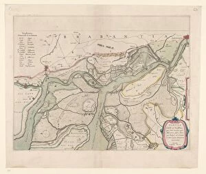
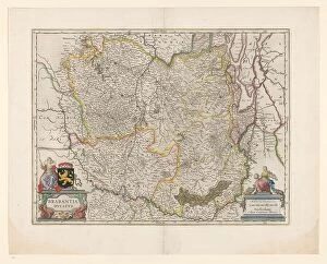
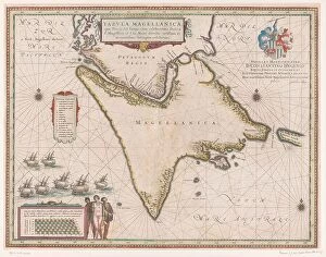
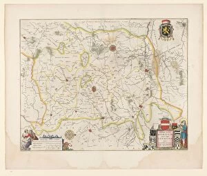
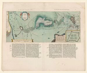
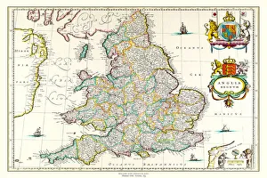
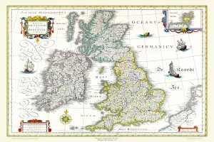
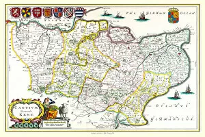
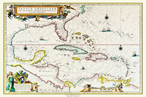
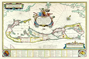
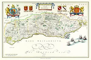
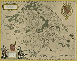
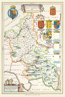
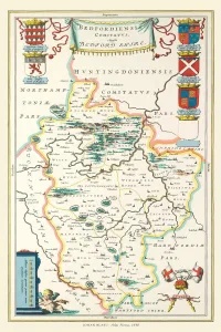
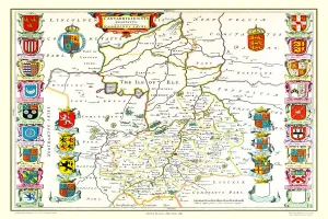
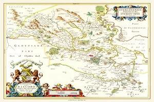
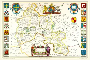
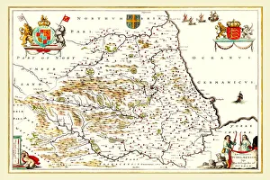
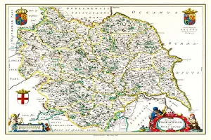
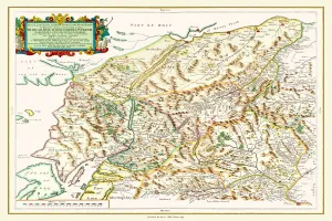
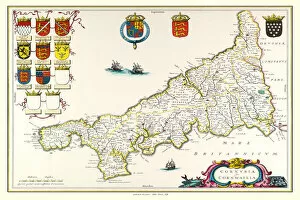
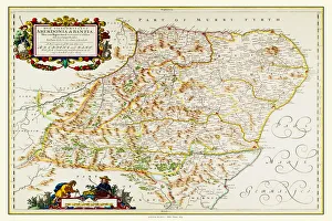
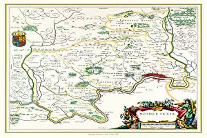
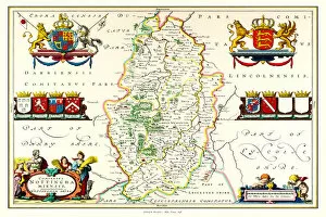
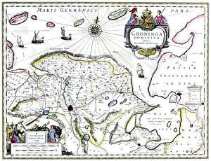
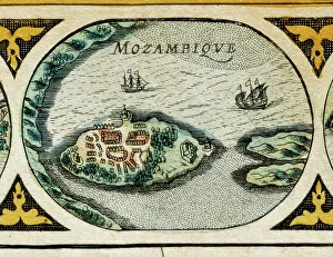
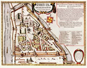
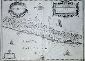
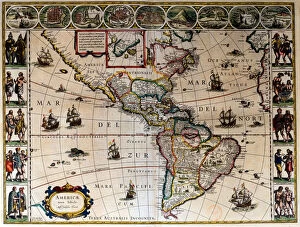
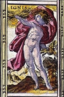
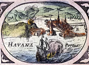
Willem Blaeu (1571-1638) was a Dutch cartographer, publisher, and globe maker. He was born in Alkmaar and studied law at the University of Franeker. In 1594 he moved to Amsterdam where he established a printing press and began producing maps. His work was highly sought after due to its accuracy and beauty; his maps were known for their vibrant colors, intricate details, and ornate borders. Blaeu's most famous works include the Atlas Maior (the largest atlas ever published), the Novus Atlas (a collection of world maps), and his globes which were considered some of the finest ever made. He also wrote several books on astronomy, navigation, geography, history, philosophy, mathematics and botany. Willem Blaeu is remembered as one of the greatest cartographers in history whose work has had an enduring influence on modern mapmaking.
+

Our beautiful Wall Art and Photo Gifts include Framed Prints, Photo Prints, Poster Prints, Canvas Prints, Jigsaw Puzzles, Metal Prints and so much more

The Willem Blaeu collection at Media Storehouse is a stunning array of wall art, framed prints, photo prints, canvas prints, jigsaw puzzles and greeting cards featuring the works of the famous Dutch cartographer and artist. Our collection showcases some of Blaeu's most iconic maps and illustrations from his 17th century atlas "Atlas Maior", which was considered one of the greatest achievements in cartography during that time. The pieces are meticulously reproduced with high-quality printing techniques to ensure that each detail is captured perfectly. From intricate depictions of celestial bodies to beautifully rendered landscapes and seascapes, our collection offers something for everyone who appreciates fine art or has an interest in history or geography. Whether you're looking for a unique gift or want to add some sophistication to your home decor, the Willem Blaeu collection is sure to impress with its timeless beauty and historical significance.
+

What are Willem Blaeu (Artists Arts) art prints?

Willem Blaeu was a Dutch cartographer, astronomer and publisher who lived in the 16th century. He is known for his stunning maps of the world, which were highly accurate and beautifully designed. His work has been reproduced as art prints by Artists Arts and are available on Media Storehouse. These art prints showcase Blaeu's intricate designs, featuring detailed depictions of continents, oceans and countries. The colors used in these prints are vibrant and eye-catching, making them perfect for adding a touch of elegance to any room. Whether you're a history buff or simply appreciate beautiful artwork, Willem Blaeu's map prints are sure to impress. They make great gifts for anyone who loves geography or wants to add some unique decor to their home or office space. Willem Blaeu's art prints offer a fascinating glimpse into the past while also providing stunning visuals that will enhance any interior design scheme.
+

What Willem Blaeu (Artists Arts) art prints can I buy from Media Storehouse?

We offer a wide range of Willem Blaeu art prints for purchase. Blaeu was a Dutch cartographer and publisher who produced some of the most beautiful maps and atlases in history during the 17th century. His works are highly sought after by collectors, historians, and enthusiasts alike. Some of the Willem Blaeu art prints available from Media Storehouse include his famous world map, Nova et Accurata Totius Terrarum Orbis Tabula, as well as various regional maps such as those depicting Europe or Asia. Additionally, there are also reproductions of his celestial charts which were used to navigate the stars. These high-quality art prints are perfect for anyone looking to add a touch of historical elegance to their home or office decor. Whether you're interested in geography or astronomy, there is sure to be a Willem Blaeu print that will catch your eye at Media Storehouse.
+

How do I buy Willem Blaeu (Artists Arts) art prints?

To purchase Willem Blaeu art prints from Media Storehouse, you can browse our extensive collection of artwork online. Once you have found the piece that you would like to purchase, simply add it to your cart and proceed to checkout. During the checkout process, you will be prompted to enter your payment and shipping information. We offer a variety of sizes for their art prints, so be sure to select the size that best fits your needs. We also offer framing options for an additional fee if desired. When purchasing Willem Blaeu art prints from Media Storehouse, rest assured that you are receiving high-quality reproductions of his original works. These prints make great additions to any home or office decor and are perfect for art enthusiasts looking for beautiful pieces at an affordable price point.
+

How much do Willem Blaeu (Artists Arts) art prints cost?

We offer a wide range of Willem Blaeu art prints for sale. The cost of these prints varies depending on the size and type of print you choose. We have a selection of high-quality paper prints that are affordable for those on a budget, as well as more expensive canvas and framed options for those looking to make a statement with their artwork. Our Willem Blaeu art prints are available in various sizes, from small 8x10 inch prints to large 24x36 inch pieces. Each print is made using the highest quality materials to ensure that it looks great and lasts for years to come. Whether you're looking for something classic or contemporary, our collection of Willem Blaeu art prints has something to suit every taste and style. So why not browse our selection today and find the perfect piece of artwork for your home or office?
+

How will my Willem Blaeu (Artists Arts) art prints be delivered to me?

We take great care in delivering your Willem Blaeu art prints to you. Once you have placed your order, our team will carefully package and ship your print using high-quality materials to ensure it arrives safely and undamaged. We use trusted shipping partners who are experienced in handling delicate items such as artwork. Your print will be rolled up and securely packaged in a sturdy tube to protect it during transit. When it arrives at your doorstep, simply unroll the print and display it as desired. Our team is dedicated to providing excellent customer service, so if you have any questions or concerns about the delivery of your Willem Blaeu art prints, please don't hesitate to get in touch with us. We hope that receiving your beautiful artwork brings joy and inspiration into your home or office space.