Home > Arts > Artists > H > Jodocus Hondius
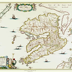
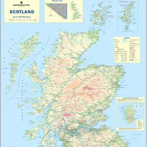
Old Map of Lothian - Scottish Lowlands by Johan Blaeu from the Atlas Novus

![]()
Wall Art and Photo Gifts from MapSeeker
Old Map of Lothian - Scottish Lowlands by Johan Blaeu from the Atlas Novus
This detailed and most attractive reproduction map of the Scottish Lowlands, known as Lothian, has been carefully art worked from a scan of an antique original. The famous firm of Dutch cartographers and publishers was established in the late 16th century by Willem Janszoon Blaeu in Amsterdam. Blaeu was a maker of globes and scientific instruments and purchased some of his early map plates from Jodocus Hondius. From this small beginning was to emerge one of the largest and most prolific map publishing houses of the seventeenth century
Welcome to the Mapseeker Image library and enter an historic gateway to one of the largest on-line collections of Historic Maps, Nostalgic Views, Vista's and Panorama's from a World gone by.
Media ID 20348003
Blaeu Blaeu Family Blaue Map Historic Map Johan Blaeu Johan Blaeu Map Old Blaue Map Lothian
FEATURES IN THESE COLLECTIONS
> Arts
> Artists
> B
> Willem Blaeu
> Arts
> Artists
> H
> Jodocus Hondius
> Arts
> Photorealistic artworks
> Detailed art pieces
> Masterful detailing in art
> Europe
> United Kingdom
> Scotland
> Lothian
> Related Images
> Europe
> United Kingdom
> Scotland
> Maps
> Maps and Charts
> Early Maps
> Maps and Charts
> Willem Janszoon Blaeu
> MapSeeker
> Maps from the British Isles
> Scotland and Counties PORTFOLIO
EDITORS COMMENTS
This beautifully crafted reproduction of an old map takes us back in time to the Scottish Lowlands, specifically Lothian. Created by Johan Blaeu, a renowned Dutch cartographer and publisher, this detailed print showcases the rich history and allure of the region. Carefully art worked from an antique original, this map captures the essence of Lothian with its intricate details and captivating aesthetics. The Blaeu family's legacy began in Amsterdam during the late 16th century when Willem Janszoon Blaeu established his firm. Initially known for crafting globes and scientific instruments, Blaeu expanded his repertoire by acquiring map plates from Jodocus Hondius. This marked the humble beginnings of what would become one of the largest and most prolific map publishing houses of the seventeenth century. As we explore this historic depiction, we are transported to a time when maps were not just navigational tools but also works of art. The Old Map of Lothian offers a glimpse into Scotland's past, showcasing its geographical features, towns, and landmarks with meticulous precision. Whether you have a personal connection to Lothian or simply appreciate historical cartography, this reproduction is sure to captivate your imagination. It serves as a testament to both Johan Blaeu's skill as a cartographer and our enduring fascination with maps that tell stories spanning centuries.
MADE IN THE USA
Safe Shipping with 30 Day Money Back Guarantee
FREE PERSONALISATION*
We are proud to offer a range of customisation features including Personalised Captions, Color Filters and Picture Zoom Tools
SECURE PAYMENTS
We happily accept a wide range of payment options so you can pay for the things you need in the way that is most convenient for you
* Options may vary by product and licensing agreement. Zoomed Pictures can be adjusted in the Cart.