Home > Arts > Artists > H > Jodocus Hondius
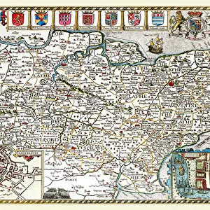
Old County Map of Hampshire 1648 by Johan Blaeu from the Atlas Novus

![]()
Wall Art and Photo Gifts from MapSeeker
Old County Map of Hampshire 1648 by Johan Blaeu from the Atlas Novus
This detailed and most attractive reproduction map of Hampshire has been carefully art worked from a scan of an antique original. The famous firm of Dutch cartographers and publishers was established in the late 16th century by Willem Janszoon Blaeu in Amsterdam. Blaeu was a maker of globes and scientific instruments and purchased some of his early map plates from Jodocus Hondius. From this small beginning was to emerge one of the largest and most prolific map publishing houses of the seventeenth century
Welcome to the Mapseeker Image library and enter an historic gateway to one of the largest on-line collections of Historic Maps, Nostalgic Views, Vista's and Panorama's from a World gone by.
Media ID 20347832
Blaeu Blaeu Family County Map County Map Of England English County Map Historic Map Johan Blaeu Johan Blaeu Map Old Blaue Map Old County Map Old English County Map Hampshire
FEATURES IN THESE COLLECTIONS
> Arts
> Artists
> B
> Willem Blaeu
> Arts
> Artists
> H
> Jodocus Hondius
> Arts
> Photorealistic artworks
> Detailed art pieces
> Masterful detailing in art
> Europe
> United Kingdom
> England
> Hampshire
> Related Images
> Europe
> United Kingdom
> England
> Maps
> Maps and Charts
> Early Maps
> Maps and Charts
> Willem Janszoon Blaeu
> MapSeeker
> Maps from the British Isles
> England and Counties PORTFOLIO
EDITORS COMMENTS
This beautifully crafted reproduction of the "Old County Map of Hampshire 1648" by Johan Blaeu takes us back in time to explore the rich history and intricate details of this English county. Carefully art worked from a scan of an antique original, this map showcases the expertise of the famous Dutch cartographers and publishers, the Blaeu family. Established in Amsterdam during the late 16th century by Willem Janszoon Blaeu, this renowned firm initially focused on globe-making and scientific instruments. However, their passion for cartography led them to become one of the largest and most prolific map publishing houses in seventeenth-century Europe. The "Old County Map of Hampshire" is a testament to their exceptional craftsmanship. Every contour line, river bend, and town placement has been meticulously reproduced to capture the essence of this historic region. As we delve into its intricacies, we can almost imagine ourselves walking through Hampshire's picturesque landscapes centuries ago. With its delicate calligraphy and vibrant colors, this map not only serves as a valuable historical document but also as a captivating piece of art that will enhance any space it adorns. Whether you are an avid collector or simply fascinated by England's past, this reproduction offers a unique glimpse into Hampshire's heritage. Transport yourself back in time with this remarkable print—a true treasure for anyone intrigued by old maps or seeking to connect with Hampshire's rich history.
MADE IN THE USA
Safe Shipping with 30 Day Money Back Guarantee
FREE PERSONALISATION*
We are proud to offer a range of customisation features including Personalised Captions, Color Filters and Picture Zoom Tools
SECURE PAYMENTS
We happily accept a wide range of payment options so you can pay for the things you need in the way that is most convenient for you
* Options may vary by product and licensing agreement. Zoomed Pictures can be adjusted in the Cart.