Home > Arts > Artists > B > Willem Blaeu
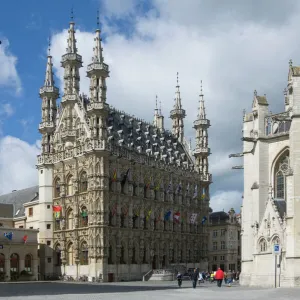
Map of Brabant, 1635. Creator: Michael van Langren

![]()
Wall Art and Photo Gifts from Heritage Images
Map of Brabant, 1635. Creator: Michael van Langren
Map of Brabant, 1635. Prima pars Brabantiae cuius caput Lovanivm'. Top right: a coat of arms; bottom right: title in a cartouche with King David playing the harp. Scale in German, Brabant and Italian miles. Man and woman with atlas and compasses
Heritage Images features heritage image collections
Media ID 36340696
© Heritage Art/Heritage Images
Atlas Blazon Brabant Cartography Coat Of Arms Coats Of Arms Compass Compasses David King Flanders Belgium Europe Harp Harpist Heraldic Heraldry King David Laurel Crown Laurel Wreath Leuven Vlaams Brabant Flanders Belgium Louvain Flemish Brabant Belgium Lyre Map Making Mapmaking Pair Of Compasses Scale Shield Of Arms Stringed Instrument Willem Blaeu Blaeu Willem Janszoon Hand Tinted Playing An Instrument Watercolour Paint Willem Jansz Blaeu Willem Janszoon Blaeu
FEATURES IN THESE COLLECTIONS
> Arts
> Artists
> B
> Willem Blaeu
> Europe
> Belgium
> Related Images
> Europe
> Germany
> Music
> Related Images
> Maps and Charts
> Willem Janszoon Blaeu
EDITORS COMMENTS
This 17th century map print, titled 'Map of Brabant, 1635. Prima pars Brabantiae cuius caput Lovanivm' (First Part of Brabant, whose head is Louvain), is an exquisite example of early modern cartography. Created by renowned Flemish cartographer Michael van Langren, this intricately detailed map showcases the region of Brabant, which encompasses present-day Belgium and parts of the Netherlands. The map is adorned with a coat of arms at the top right, representing the Duchy of Brabant, and a title in a decorative cartouche at the bottom right. The cartouche features King David, depicted as a harpist, symbolizing the harmony and unity of the region. The map is available in both German, Brabant, and Italian miles, reflecting the international influence of cartography during this period. The map is not only a testament to the artistic and cartographic skills of Michael van Langren but also a rich source of historical information. The map is hand-colored, adding an additional layer of visual appeal. The use of a laurel wreath and a crown further emphasizes the significance and importance of the region. The mapmaking process involved a great deal of precision and care, as evidenced by the pair of compasses and the man and woman holding an atlas in the image. The mapmaking process was a complex and time-consuming endeavor, requiring extensive knowledge of geography, mathematics, and art. This map is a valuable addition to any collection of historical maps, art, or European history. It offers a glimpse into the past, providing insights into the cartographic practices and artistic styles of the 17th century. The map is a testament to the rich heritage of cartography and the enduring appeal of maps as works of art.
MADE IN THE USA
Safe Shipping with 30 Day Money Back Guarantee
FREE PERSONALISATION*
We are proud to offer a range of customisation features including Personalised Captions, Color Filters and Picture Zoom Tools
SECURE PAYMENTS
We happily accept a wide range of payment options so you can pay for the things you need in the way that is most convenient for you
* Options may vary by product and licensing agreement. Zoomed Pictures can be adjusted in the Cart.