Home > Arts > Artists > B > Willem Blaeu
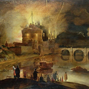
Map of the area between Bergen op Zoom and Steenbergen, 1630. Creator: Franciscus van Schooten

![]()
Wall Art and Photo Gifts from Heritage Images
Map of the area between Bergen op Zoom and Steenbergen, 1630. Creator: Franciscus van Schooten
Map of the area between Bergen op Zoom and Steenbergen, 1630. Tabula Bergarum ad Zomam Stenbergae'. Showing fortresses, trees, hills, harbours, areas susceptible to flooding, roads and agricultural land. Bottom left, scale in Rhineland rods. Bottom right inset, map of a fortress, Castra Pinsii
Heritage Images features heritage image collections
Media ID 36339327
© Heritage Art/Heritage Images
Bad Weather City Walls Dike Dikes Dyke Dykes Flood Flood Defence Flooded Flooding Floods Fort Fortress Fortresses Forts Polder Polders Rivers Tools Town Wall Walled City Walled Town Willem Blaeu Blaeu Willem Janszoon Fortifications Watercolour Paint Willem Jansz Blaeu Willem Janszoon Blaeu
FEATURES IN THESE COLLECTIONS
> Arts
> Artists
> B
> Willem Blaeu
> Arts
> Landscape paintings
> Waterfall and river artworks
> Nature-inspired paintings
> Arts
> Watercolor paintings
> Nature-inspired watercolors
> Waterfall and river scenes in
> Europe
> Netherlands
> Castles
> Europe
> Netherlands
> Maps
> Europe
> Netherlands
> Posters
> Europe
> Netherlands
> Related Images
> Europe
> Netherlands
> Rivers
> Historic
> Medieval architecture
> Castles and fortresses
> Ancient fortifications
> Maps and Charts
> Netherlands
> Maps and Charts
> Willem Janszoon Blaeu
EDITORS COMMENTS
This exquisite map, titled 'Tabula Bergarum ad Zomam Stenbergae' or 'Map of the area between Bergen op Zoom and Steenbergen,' was created by the renowned Dutch cartographer Franciscus van Schooten in the year 1630. The map provides a detailed and intricately accurate representation of the geographical features and human-made structures in the region between Bergen op Zoom and Steenbergen in North Brabant, Netherlands. Van Schooten masterfully depicts the area's topography, including hills, trees, and bodies of water, as well as the fortresses and city walls that protected the towns and cities from potential threats. The map also highlights areas susceptible to flooding and the crucial dike systems that were essential for flood defence. The bottom left corner of the map includes a scale in Rhineland rods, providing a sense of proportion and accuracy. An inset map of the fortress Castra Pinsii is located in the bottom right corner, offering a closer look at the intricacies of this important military installation. This map is a testament to the meticulous cartographic skills of Franciscus van Schooten, who used a combination of etching and watercolour techniques to create a visually stunning and informative representation of the region. The map's rich details offer a glimpse into the history and geography of the Low Countries during the 17th century, making it an invaluable resource for scholars, historians, and anyone interested in the heritage of Europe. This map is not to be confused with the Blaeu company, despite their shared Dutch heritage. Instead, it is a unique work by Franciscus van Schooten, showcasing his exceptional talent and dedication to the art of cartography.
MADE IN THE USA
Safe Shipping with 30 Day Money Back Guarantee
FREE PERSONALISATION*
We are proud to offer a range of customisation features including Personalised Captions, Color Filters and Picture Zoom Tools
SECURE PAYMENTS
We happily accept a wide range of payment options so you can pay for the things you need in the way that is most convenient for you
* Options may vary by product and licensing agreement. Zoomed Pictures can be adjusted in the Cart.