Poster Print > North America > Related Images
Poster Print : EXPL2A-00171


![]()
Poster Prints from North Wind
EXPL2A-00171
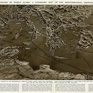
Map showing the route of La Salles explorations in North America, late 1600s.
Hand-colored woodcut of a 19th-century illustration
North Wind Picture Archives brings history to life with stock images and hand-colored illustrations
Media ID 5880984
© North Wind Picture Archives
1600s 1680s 17th Century Canada Canadian Colonial Colony Discover Expedition Exploration Explore French French Canada Frontier Great Lakes Journey La Salle Lake Lake Michigan Land Claim Michigan Mississippi Mississippi River Montreal New France Quebec River Route Territory Travel Cavelier Rene Robert Cavelier
18x24 inch Poster Print
Discover the rich history of North America's exploration with our stunning Media Storehouse Poster Print of EXPL2A-00171 from North Wind Picture Archives. This captivating hand-colored woodcut illustration depicts the route of Father Jacques Marquette and Louis Jolliet's epic journey through the continent in the late 1600s. Add this intriguing piece to your home or office to ignite conversations and transport you back in time. Experience the adventure and curiosity of early exploration with our high-quality poster print.
Poster prints are budget friendly enlarged prints in standard poster paper sizes. Printed on 150 gsm Matte Paper for a natural feel and supplied rolled in a tube. Great for framing and should last many years. To clean wipe with a microfiber, non-abrasive cloth or napkin. Our Archival Quality Photo Prints and Fine Art Paper Prints are printed on higher quality paper and the choice of which largely depends on your budget.
Poster prints are budget friendly enlarged prints in standard poster paper sizes (A0, A1, A2, A3 etc). Whilst poster paper is sometimes thinner and less durable than our other paper types, they are still ok for framing and should last many years. Our Archival Quality Photo Prints and Fine Art Paper Prints are printed on higher quality paper and the choice of which largely depends on your budget.
Estimated Product Size is 46.3cm x 61.6cm (18.2" x 24.3")
These are individually made so all sizes are approximate
Artwork printed orientated as per the preview above, with portrait (vertical) orientation to match the source image.
FEATURES IN THESE COLLECTIONS
> North Wind Picture Archives
> Exploration
> North Wind Picture Archives
> Maps
> North America
> Related Images
EDITORS COMMENTS
This vintage print showcases the historic journey of La Salle's explorations in North America during the late 1600s. The hand-colored woodcut, derived from a 19th-century illustration, beautifully depicts the route taken by this intrepid explorer. The map highlights key locations such as Quebec, Montreal, and Lake Michigan, providing a visual representation of La Salle's colonial expedition through French Canada. As we delve into history, we discover that his exploration played a crucial role in shaping the territory known as New France. With meticulous detail and artistry, this print invites us to embark on an imaginary voyage alongside La Salle. We can almost feel the excitement and anticipation he must have experienced while charting new territories and claiming land for France. As our eyes trace the intricate lines of rivers like the Mississippi River and navigate across Great Lakes like Lake Michigan, we are transported back to an era when North America was still largely unexplored by Europeans. This print serves as both a historical document and a work of art. It allows us to appreciate not only La Salle's significant contributions but also the skillful craftsmanship involved in creating this exquisite woodcut illustration. Whether you are an avid history enthusiast or simply captivated by vintage aesthetics, this piece is sure to ignite your imagination and transport you back in time to witness one man's extraordinary journey through uncharted lands.
MADE IN THE USA
Safe Shipping with 30 Day Money Back Guarantee
FREE PERSONALISATION*
We are proud to offer a range of customisation features including Personalised Captions, Color Filters and Picture Zoom Tools
SECURE PAYMENTS
We happily accept a wide range of payment options so you can pay for the things you need in the way that is most convenient for you
* Options may vary by product and licensing agreement. Zoomed Pictures can be adjusted in the Cart.