Poster Print > Europe > United Kingdom > England > Maps
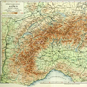
Poster Print : 1890, Bacon Travelers Pocket Map of London, England, topography, cartography


![]()
Poster Prints from Liszt Collection
1890, Bacon Travelers Pocket Map of London, England, topography, cartography
1890, Bacon Travelers Pocket Map of London, England
Liszt Collection of nineteenth-century engravings and images to browse and enjoy
Media ID 14006436
© Artokoloro Quint Lox Limited
1890 Antique Map Latitude Longitude Mappa Mundi Old Antique Plan Old Antique View Ols Antique Map Rare Old Maps Topo
18x24 inch Poster Print
Step back in time with our vintage 1890 Bacon Travelers Pocket Map of London from the esteemed Liszt Collection. This exquisite poster print showcases an intricately detailed topographical map of London, England, as it appeared over a century ago. The cartography is a captivating blend of historical accuracy and artistic flair, making it an essential addition to any home or office space. Transport yourself back to the late 19th century and marvel at the evolution of London's urban landscape. This beautiful poster print is a testament to the rich history of cartography and a stunning conversation starter. Order yours today and bring a piece of the past into your present.
Poster prints are budget friendly enlarged prints in standard poster paper sizes. Printed on 150 gsm Matte Paper for a natural feel and supplied rolled in a tube. Great for framing and should last many years. To clean wipe with a microfiber, non-abrasive cloth or napkin. Our Archival Quality Photo Prints and Fine Art Paper Prints are printed on higher quality paper and the choice of which largely depends on your budget.
Poster prints are budget friendly enlarged prints in standard poster paper sizes (A0, A1, A2, A3 etc). Whilst poster paper is sometimes thinner and less durable than our other paper types, they are still ok for framing and should last many years. Our Archival Quality Photo Prints and Fine Art Paper Prints are printed on higher quality paper and the choice of which largely depends on your budget.
Estimated Product Size is 61.6cm x 46.3cm (24.3" x 18.2")
These are individually made so all sizes are approximate
Artwork printed orientated as per the preview above, with landscape (horizontal) orientation to match the source image.
FEATURES IN THESE COLLECTIONS
> Europe
> France
> Canton
> Landes
> Europe
> United Kingdom
> England
> Maps
> Historic
> Space exploration
> Maps and Charts
> Early Maps
> Maps and Charts
> Related Images
> Maps and Charts
> World
EDITORS COMMENTS
This print showcases a remarkable piece of history - the 1890 Bacon Travelers Pocket Map of London, England. With its intricate topography and detailed cartography, this map offers a fascinating glimpse into the past. The rich geography and land formations are beautifully illustrated, providing an invaluable resource for travelers and explorers alike. The grid lines marking latitude and longitude add a touch of precision to this geometric masterpiece. As you examine each corner of the map, you can't help but be transported back in time to an era when navigation relied on paper maps like these. This vintage treasure holds not only historical significance but also artistic value. Its aged appearance adds to its charm as it tells stories of journeys taken and discoveries made throughout London's vibrant regions. As you study this ancient relic, it becomes clear that it is more than just a map; it is a portal into the past. It serves as a reminder of how far we have come in terms of geographical knowledge and technological advancements. Whether you are an enthusiast for antique maps or simply appreciate art with historical context, this rare find from the Liszt Collection will undoubtedly captivate your imagination. Let yourself be immersed in the world depicted on this old antique view - one that has shaped our understanding of London's landscape for generations.
MADE IN THE USA
Safe Shipping with 30 Day Money Back Guarantee
FREE PERSONALISATION*
We are proud to offer a range of customisation features including Personalised Captions, Color Filters and Picture Zoom Tools
SECURE PAYMENTS
We happily accept a wide range of payment options so you can pay for the things you need in the way that is most convenient for you
* Options may vary by product and licensing agreement. Zoomed Pictures can be adjusted in the Cart.