Canvas Print > Europe > United Kingdom > England > Maps
Canvas Print : 1890, Bacon Travelers Pocket Map of London, England, topography, cartography


![]()
Canvas Prints from Liszt Collection
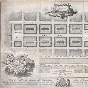
1890, Bacon Travelers Pocket Map of London, England, topography, cartography
1890, Bacon Travelers Pocket Map of London, England
Liszt Collection of nineteenth-century engravings and images to browse and enjoy
Media ID 14006436
© Artokoloro Quint Lox Limited
1890 Antique Map Latitude Longitude Mappa Mundi Old Antique Plan Old Antique View Ols Antique Map Rare Old Maps Topo
20"x16" (51x41cm) Canvas Print
Step back in time with our exquisite Media Storehouse Canvas Print featuring the 1890 Bacon Travelers Pocket Map of London from the renowned Liszt Collection. This captivating vintage map showcases the topography and cartography of London during an era of great historical significance. Each canvas print is meticulously crafted using premium materials and high-definition printing techniques to bring the intricate details of this antique map to life. Hang this unique piece in your home or office to add a touch of historical charm and intrigue to your space.
Delivered stretched and ready to hang our premium quality canvas prints are made from a polyester/cotton blend canvas and stretched over a 1.25" (32mm) kiln dried knot free wood stretcher bar. Packaged in a plastic bag and secured to a cardboard insert for safe transit.
Canvas Prints add colour, depth and texture to any space. Professionally Stretched Canvas over a hidden Wooden Box Frame and Ready to Hang
Estimated Product Size is 50.8cm x 40.6cm (20" x 16")
These are individually made so all sizes are approximate
Artwork printed orientated as per the preview above, with landscape (horizontal) orientation to match the source image.
FEATURES IN THESE COLLECTIONS
> Europe
> France
> Canton
> Landes
> Europe
> United Kingdom
> England
> Maps
> Historic
> Space exploration
> Maps and Charts
> Early Maps
> Maps and Charts
> Related Images
> Maps and Charts
> World
EDITORS COMMENTS
This print showcases a remarkable piece of history - the 1890 Bacon Travelers Pocket Map of London, England. With its intricate topography and detailed cartography, this map offers a fascinating glimpse into the past. The rich geography and land formations are beautifully illustrated, providing an invaluable resource for travelers and explorers alike. The grid lines marking latitude and longitude add a touch of precision to this geometric masterpiece. As you examine each corner of the map, you can't help but be transported back in time to an era when navigation relied on paper maps like these. This vintage treasure holds not only historical significance but also artistic value. Its aged appearance adds to its charm as it tells stories of journeys taken and discoveries made throughout London's vibrant regions. As you study this ancient relic, it becomes clear that it is more than just a map; it is a portal into the past. It serves as a reminder of how far we have come in terms of geographical knowledge and technological advancements. Whether you are an enthusiast for antique maps or simply appreciate art with historical context, this rare find from the Liszt Collection will undoubtedly captivate your imagination. Let yourself be immersed in the world depicted on this old antique view - one that has shaped our understanding of London's landscape for generations.
MADE IN THE USA
Safe Shipping with 30 Day Money Back Guarantee
FREE PERSONALISATION*
We are proud to offer a range of customisation features including Personalised Captions, Color Filters and Picture Zoom Tools
SECURE PAYMENTS
We happily accept a wide range of payment options so you can pay for the things you need in the way that is most convenient for you
* Options may vary by product and licensing agreement. Zoomed Pictures can be adjusted in the Cart.