Metal Print > Europe > United Kingdom > England > Maps
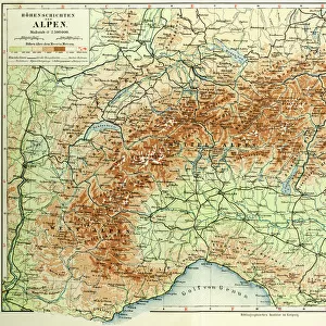
Metal Print : 1890, Bacon Travelers Pocket Map of London, England, topography, cartography


![]()
Metal Prints from Liszt Collection
1890, Bacon Travelers Pocket Map of London, England, topography, cartography
1890, Bacon Travelers Pocket Map of London, England
Liszt Collection of nineteenth-century engravings and images to browse and enjoy
Media ID 14006436
© Artokoloro Quint Lox Limited
1890 Antique Map Latitude Longitude Mappa Mundi Old Antique Plan Old Antique View Ols Antique Map Rare Old Maps Topo
16"x20" (51x41cm) Metal Print
Step back in time with our exquisite Media Storehouse Metal Print featuring the 1890 Bacon Travelers Pocket Map of London. This vintage cartography piece, sourced from the esteemed Liszt Collection, showcases the topography of London during an era of horse-drawn carriages and bustling streets. The intricate details of the map are brought to life in brilliant clarity on our high-quality metal print, creating a stunning and unique piece of decor for your home or office. Transport yourself back in time and add a touch of history to your space with this captivating and collectible print.
Made with durable metal and luxurious printing techniques, our metal photo prints go beyond traditional canvases, adding a cool, modern touch to your space. Wall mount on back. Eco-friendly 100% post-consumer recycled ChromaLuxe aluminum surface. The thickness of the print is 0.045". Featuring a Scratch-resistant surface and Rounded corners. Backing hangers are attached to the back of the print and float the print 1/2-inch off the wall when hung, the choice of hanger may vary depending on size and International orders will come with Float Mount hangers only. Finished with a brilliant white high gloss surface for unsurpassed detail and vibrance. Printed using Dye-Sublimation and for best care we recommend a non-ammonia glass cleaner, water, or isopropyl (rubbing) alcohol to prevent harming the print surface. We recommend using a clean, lint-free cloth to wipe off the print. The ultra-hard surface is scratch-resistant, waterproof and weatherproof. Avoid direct sunlight exposure.
Made with durable metal and luxurious printing techniques, metal prints bring images to life and add a modern touch to any space
Estimated Image Size (if not cropped) is 50.8cm x 40.6cm (20" x 16")
Estimated Product Size is 51.4cm x 41.2cm (20.2" x 16.2")
These are individually made so all sizes are approximate
Artwork printed orientated as per the preview above, with landscape (horizontal) orientation to match the source image.
FEATURES IN THESE COLLECTIONS
> Europe
> France
> Canton
> Landes
> Europe
> United Kingdom
> England
> Maps
> Historic
> Space exploration
> Maps and Charts
> Early Maps
> Maps and Charts
> Related Images
> Maps and Charts
> World
EDITORS COMMENTS
This print showcases a remarkable piece of history - the 1890 Bacon Travelers Pocket Map of London, England. With its intricate topography and detailed cartography, this map offers a fascinating glimpse into the past. The rich geography and land formations are beautifully illustrated, providing an invaluable resource for travelers and explorers alike. The grid lines marking latitude and longitude add a touch of precision to this geometric masterpiece. As you examine each corner of the map, you can't help but be transported back in time to an era when navigation relied on paper maps like these. This vintage treasure holds not only historical significance but also artistic value. Its aged appearance adds to its charm as it tells stories of journeys taken and discoveries made throughout London's vibrant regions. As you study this ancient relic, it becomes clear that it is more than just a map; it is a portal into the past. It serves as a reminder of how far we have come in terms of geographical knowledge and technological advancements. Whether you are an enthusiast for antique maps or simply appreciate art with historical context, this rare find from the Liszt Collection will undoubtedly captivate your imagination. Let yourself be immersed in the world depicted on this old antique view - one that has shaped our understanding of London's landscape for generations.
MADE IN THE USA
Safe Shipping with 30 Day Money Back Guarantee
FREE PERSONALISATION*
We are proud to offer a range of customisation features including Personalised Captions, Color Filters and Picture Zoom Tools
SECURE PAYMENTS
We happily accept a wide range of payment options so you can pay for the things you need in the way that is most convenient for you
* Options may vary by product and licensing agreement. Zoomed Pictures can be adjusted in the Cart.