Metal Print > Fine Art Storehouse > Map
Metal Print : nobody, antique, vintage, archival, cartography, geography, map, history, historical


![]()
Metal Prints from Fine Art Storehouse
nobody, antique, vintage, archival, cartography, geography, map, history, historical
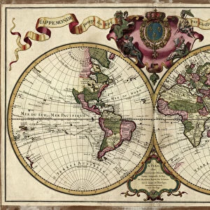
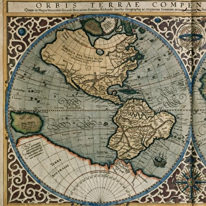
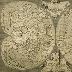
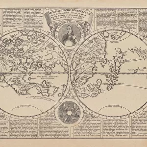
nobody, antique, vintage, archival, cartography, geography, map, history, historical, north pole, south pole, continents, world, earth, north america, south america, europe, africa, asia, australia, northern, southern, hemisphere, latitude, longitude, chart, 18th century, circles, intersecting, words, text, numbers, labels, Antique Maps, 87644530
Unleash your creativity and transform your space into a visual masterpiece!
Hemera Technologies
Media ID 14761282
© Getty Images
18th Century Australia Chart Circles Continents Earth Geography Hemisphere Labels Latitude Longitude North America North Pole Northern Numbers South America South Pole Southern Text Words World Intersecting
16"x20" (51x41cm) Metal Print
Step into the past with our Media Storehouse Metal Prints from Fine Art Storehouse. These stunning, museum-quality pieces feature captivating antique, vintage, and archival maps from around the world. Explore the mysteries of history with intricate cartography depicting the continents of North America, South America, Europe, Africa, Asia, and Australia. Delve into the unexplored territories of the North and South Poles. Each print is meticulously crafted on high-quality metal, enhancing the intricate details and textures of the maps. Bring a piece of the world's rich history into your home or office, and let the stories of the past come alive.
Made with durable metal and luxurious printing techniques, our metal photo prints go beyond traditional canvases, adding a cool, modern touch to your space. Wall mount on back. Eco-friendly 100% post-consumer recycled ChromaLuxe aluminum surface. The thickness of the print is 0.045". Featuring a Scratch-resistant surface and Rounded corners. Backing hangers are attached to the back of the print and float the print 1/2-inch off the wall when hung, the choice of hanger may vary depending on size and International orders will come with Float Mount hangers only. Finished with a brilliant white high gloss surface for unsurpassed detail and vibrance. Printed using Dye-Sublimation and for best care we recommend a non-ammonia glass cleaner, water, or isopropyl (rubbing) alcohol to prevent harming the print surface. We recommend using a clean, lint-free cloth to wipe off the print. The ultra-hard surface is scratch-resistant, waterproof and weatherproof. Avoid direct sunlight exposure.
Made with durable metal and luxurious printing techniques, metal prints bring images to life and add a modern touch to any space
Estimated Image Size (if not cropped) is 40.6cm x 50.8cm (16" x 20")
Estimated Product Size is 41.2cm x 51.4cm (16.2" x 20.2")
These are individually made so all sizes are approximate
Artwork printed orientated as per the preview above, with portrait (vertical) orientation to match the source image.
FEATURES IN THESE COLLECTIONS
> Fine Art Storehouse
> Map
> Historical Maps
EDITORS COMMENTS
This print by Hemera Technologies takes us on a journey through time and space. An antique map from the 18th century, it is a testament to the artistry and precision of cartography in days gone by. The image showcases a beautifully preserved piece of history, with intricate details that transport us back to an era when exploration and discovery were at their peak. The continents are meticulously outlined, revealing the vastness of our world and its diverse landscapes. As we study this vintage map, we can't help but marvel at the intersecting circles denoting latitude and longitude, guiding sailors across uncharted waters. Words, text, and numbers adorn the chart, providing valuable information about different regions. With labels indicating North Pole, South Pole, North America, South America, Europe, Africa Asia Australia - it's like stepping into an explorer's dream. This archival gem offers glimpses into both hemispheres as well as Northern and Southern territories. The print exudes nostalgia for a time when maps were cherished possessions; windows into unknown lands waiting to be discovered. It serves as a reminder of our planet's rich history while igniting curiosity about those who came before us. Whether you're an avid collector or simply appreciate historical artifacts that tell stories without words – this antique map print is sure to captivate your imagination. Let it transport you to distant lands where adventure awaits!
MADE IN THE USA
Safe Shipping with 30 Day Money Back Guarantee
FREE PERSONALISATION*
We are proud to offer a range of customisation features including Personalised Captions, Color Filters and Picture Zoom Tools
SECURE PAYMENTS
We happily accept a wide range of payment options so you can pay for the things you need in the way that is most convenient for you
* Options may vary by product and licensing agreement. Zoomed Pictures can be adjusted in the Cart.