Home > Maps and Charts > World
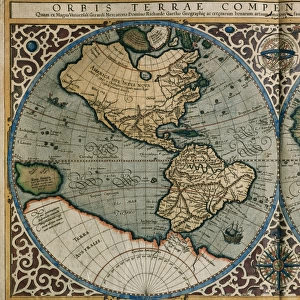
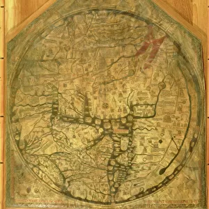
World map. Italian engraving. 16th century

![]()
Wall Art and Photo Gifts from Mary Evans Picture Library
World map. Italian engraving. 16th century
Mary Evans Picture Library makes available wonderful images created for people to enjoy over the centuries
Media ID 14337097
© Thaliastock / Mary Evans
Antique Cartography Earth Geographer Geography Globe Renaissance
FEATURES IN THESE COLLECTIONS
> Europe
> Related Images
> Maps and Charts
> Early Maps
> Maps and Charts
> World
EDITORS COMMENTS
16th Century Italian Engraving: A Voyage Through the Uncharted Waters of the World This exquisite 16th century Italian engraving presents a captivating and intriguing portrayal of the known world during the Renaissance era. The meticulously crafted map, adorned with elegant cartouches and richly detailed illustrations, invites us to embark on a journey through time and space. The map, believed to have been produced in Italy during the late 1500s, showcases the state of geographical knowledge during this pivotal period in human history. Europe, with its intricate network of rivers and mountain ranges, dominates the center of the map, while Asia, Africa, and the Americas stretch out towards the periphery. The map's creator, a skilled geographer and artist of the time, meticulously recorded the latest discoveries and explorations, incorporating newfound knowledge of the world into this masterpiece. The presence of the New World, only recently discovered by European explorers, is evident, with the outlines of South America and the Caribbean islands visible for the first time on a European map. The intricate detail and artistic flair evident in this engraving are characteristic of the Renaissance period, a time of great intellectual and artistic achievement. The map's cartouches, featuring elaborate designs and mythological figures, serve as visual embellishments, while the use of vivid colors and shading adds depth and dimension to the representation of the world. This 16th century Italian engraving is a testament to the curiosity and exploratory spirit of the Renaissance era, a time when the known world expanded and new horizons were discovered. It serves as a reminder of the importance of geographical knowledge in shaping our understanding of the world and our place within it.
MADE IN THE USA
Safe Shipping with 30 Day Money Back Guarantee
FREE PERSONALISATION*
We are proud to offer a range of customisation features including Personalised Captions, Color Filters and Picture Zoom Tools
SECURE PAYMENTS
We happily accept a wide range of payment options so you can pay for the things you need in the way that is most convenient for you
* Options may vary by product and licensing agreement. Zoomed Pictures can be adjusted in the Cart.