Home > Asia > Singapore > Maps
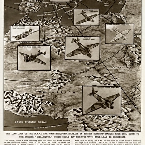
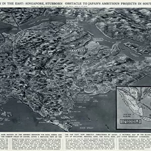
Map of Japanese invasion receding by G. H. Davis

![]()
Wall Art and Photo Gifts from Mary Evans Picture Library
Map of Japanese invasion receding by G. H. Davis
A pictorial map of the Pacific area, showing how the wave of Japanese invasion receded as a result of the Allied strategy during the Second World War. Showing Japans conquests, dates of occupation, and reconquests. Date: 1945
Mary Evans Picture Library makes available wonderful images created for people to enjoy over the centuries
Media ID 14133549
© Illustrated London News Ltd/Mary Evans
1945 Allied Area Conquests Dates Davis Guinea Invasion Maps Occupation Pacific Philippines Pictorial Power Singapore Strategy Struggle Sumatra Receded
FEATURES IN THESE COLLECTIONS
> Asia
> Philippines
> Maps
> Asia
> Singapore
> Singapore
> Maps and Charts
> Early Maps
> Maps and Charts
> World
EDITORS COMMENTS
This pictorial map, titled "Map of Japanese Invasion Receding," is a testament to the historical turning point of the Pacific Theater during World War II. Created by renowned cartographer G.H. Davis in 1945, this map offers a visual representation of the ebb and flow of the Japanese invasion and subsequent Allied reconquests. The vibrant and intricately detailed map displays the vast Pacific area, with a focus on the East and Eastern Pacific Ocean, China, the Philippines, Singapore, Sumatra, New Guinea, and Australia. The map's central theme is the Japanese conquests, meticulously marked with dates of occupation, providing a visual timeline of the invasion's progression. However, the true power of this map lies in its depiction of the Japanese invasion's recession. As the Allied strategy began to take hold, the once-expanding wave of Japanese control began to recede, as evidenced by the reconquered territories marked on the map. The map serves as a poignant reminder of the intense power struggle that defined the wartime Pacific, and the eventual triumph of the Allied forces. The map's historical significance is further emphasized by its inclusion of key dates and locations, offering viewers a unique perspective on the Pacific War's pivotal moments. This and informative map is a must-have for history enthusiasts, educators, and anyone interested in understanding the complexities of World War II's Pacific Theater.
MADE IN THE USA
Safe Shipping with 30 Day Money Back Guarantee
FREE PERSONALISATION*
We are proud to offer a range of customisation features including Personalised Captions, Color Filters and Picture Zoom Tools
SECURE PAYMENTS
We happily accept a wide range of payment options so you can pay for the things you need in the way that is most convenient for you
* Options may vary by product and licensing agreement. Zoomed Pictures can be adjusted in the Cart.