
Receded Collection
From the receding waters of the North American Colorado River at Hite Overlook in Utah's Glen Canyon National Recreation Area, to the melting Arctic ice in 2012 and 2013


All Professionally Made to Order for Quick Shipping
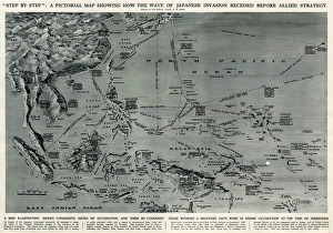
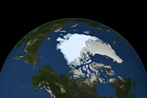
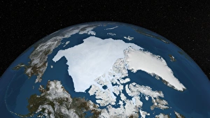
From the receding waters of the North American Colorado River at Hite Overlook in Utah's Glen Canyon National Recreation Area, to the melting Arctic ice in 2012 and 2013, the world continues to change at a rapid pace. This transformation echoes the biblical tale of Noah's Ark, as the animals disembark and the floodwaters recede. Yet, this modern-day deluge holds a different meaning. The once frozen landscapes of Mount Ararat in Turkey, where some believe Noah's Ark came to rest, now bear witness to the 18th century map of Japanese invasion receding. Similarly, the once impassable Northwest Passage in the Arctic Ocean has opened up, much like the calm sea depicted in the 1869 oil canvas "Calm Sea." As we navigate these shifting tides, we are reminded of the ever-evolving nature of our planet and the importance of adapting to change.