Home > Africa > Libya > Maps
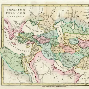
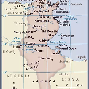
Framed Print : Map / North Africa 19C


![]()
Framed Photos from Mary Evans Picture Library
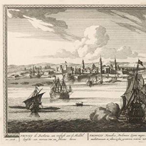
Map / North Africa 19C
Tunisia and Tripoli (now largely Libya)
Mary Evans Picture Library makes available wonderful images created for people to enjoy over the centuries
Media ID 605183
© Mary Evans Picture Library 2015 - https://copyrighthub.org/s0/hub1/creation/maryevans/MaryEvansPictureID/10052280
1850 Largely Libya Maps Tripoli Tunisia
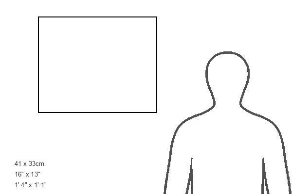
16"x13" Modern Frame
Introducing the captivating "Map / North Africa 19C" print from the Media Storehouse collection, brought to you in collaboration with Mary Evans Picture Library from Mary Evans Prints Online. This intriguing piece transports you back in time, showcasing an exquisite 19th-century map of North Africa, featuring Tunisia and Tripoli, which is now largely a part of Libya. This beautifully framed print is a perfect addition to any room, adding a touch of history and culture to your decor. With its rich details and vintage charm, this map print is sure to ignite your curiosity and inspire endless conversations. Bring a piece of the past into your present with the "Map / North Africa 19C" print from Media Storehouse.
14x11 Print in an MDF Wooden Frame with 180 gsm Satin Finish Paper. Glazed using shatter proof thin plexi glass. Frame thickness is 1 inch and depth 0.75 inch. Fluted cardboard backing held with clips. Supplied ready to hang with sawtooth hanger and rubber bumpers. Spot clean with a damp cloth. Packaged foam wrapped in a card.
Contemporary Framed and Mounted Prints - Professionally Made and Ready to Hang
Estimated Image Size (if not cropped) is 35.5cm x 33cm (14" x 13")
Estimated Product Size is 40.6cm x 33cm (16" x 13")
These are individually made so all sizes are approximate
Artwork printed orientated as per the preview above, with landscape (horizontal) orientation to match the source image.
FEATURES IN THESE COLLECTIONS
> Africa
> Libya
> Related Images
> Africa
> Related Images
> Africa
> Tunisia
> Related Images
> Maps and Charts
> Early Maps
> Maps and Charts
> Related Images
EDITORS COMMENTS
This stunning historical print from Mary Evans Picture Library takes us back to the 19th century, offering a glimpse into the intricate details of a map showcasing North Africa, specifically Tunisia and Tripoli (now largely Libya). The map, dating back to around 1850, provides a fascinating look at the geographical landscape of these regions during this time period.
As we study the intricate lines and markings on this map, we are transported to an era where exploration and discovery were at the forefront of human curiosity. The detailed cartography gives us insight into how these areas were perceived and understood by explorers and cartographers in the 19th century.
Tunisia and Tripoli (Libya) are highlighted on this map, showcasing their importance in North African history. The names of cities, rivers, mountains, and other landmarks are meticulously labeled, providing a wealth of information for those eager to learn more about this region's past.
Whether you're a history buff or simply appreciate fine craftsmanship, this print is sure to captivate your imagination. It serves as a reminder of how maps have played a crucial role in shaping our understanding of the world around us. Let yourself be transported back in time with this exquisite piece from Mary Evans Prints Online.
MADE IN THE USA
Safe Shipping with 30 Day Money Back Guarantee
FREE PERSONALISATION*
We are proud to offer a range of customisation features including Personalised Captions, Color Filters and Picture Zoom Tools
SECURE PAYMENTS
We happily accept a wide range of payment options so you can pay for the things you need in the way that is most convenient for you
* Options may vary by product and licensing agreement. Zoomed Pictures can be adjusted in the Cart.