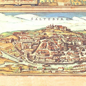
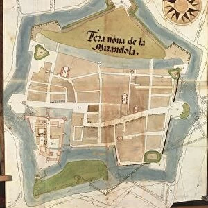
Framed Print : Map of Cherasco, Cuneo and its surroundings, 1720


![]()
Framed Photos From Universal Images Group (UIG)
Map of Cherasco, Cuneo and its surroundings, 1720
Cartography, Italy, 18th century. Map of Cherasco, Cuneo and its surroundings in 1720
Universal Images Group (UIG) manages distribution for many leading specialist agencies worldwide
Media ID 9572067
© DEA / A. DE GREGORIO
1720 18th Century Aerial View Cuneo Field Guidance Hill Human Settlement Mountain Navigational Equipment Old Fashioned Piedmont Text Town Western Script Non Urban Scene
18"x14" Modern Frame
Discover the rich history of Italy's Piedmont region with our exquisite Framed Print from Media Storehouse, featuring a captivating map of Cherasco and its surroundings from 1720. This beautifully preserved cartographic masterpiece, sourced from Universal Images Group (UIG), offers a fascinating glimpse into the 18th century. Add this elegant and informative piece to your home or office decor, and let the intricate details of the map transport you to another time and place. A perfect addition for history enthusiasts, cartography collectors, or anyone with an appreciation for the beauty of the past.
16x12 Print in an MDF Wooden Frame with 180 gsm Satin Finish Paper. Glazed using shatter proof thin plexiglass. Frame thickness is 1 inch and depth 0.75 inch. Fluted cardboard backing held with clips. Supplied ready to hang with sawtooth hanger and rubber bumpers. Spot clean with a damp cloth. Packaged foam wrapped in a card.
Contemporary Framed and Mounted Prints - Professionally Made and Ready to Hang
Estimated Image Size (if not cropped) is 35.6cm x 40.6cm (14" x 16")
Estimated Product Size is 35.6cm x 45.7cm (14" x 18")
These are individually made so all sizes are approximate
Artwork printed orientated as per the preview above, with portrait (vertical) orientation to match the source image.
EDITORS COMMENTS
This print takes us back to the 18th century, immersing us in the rich history and topography of Cherasco, Cuneo, and its surrounding areas in Italy. The meticulously detailed map from 1720 showcases the town nestled amidst majestic mountains and rolling hills. Its old-fashioned charm is evident through the use of Western script and engraved images. The vertical composition allows for a comprehensive aerial view that reveals the landscape's natural beauty. With no people present, we are left to marvel at this non-urban scene, appreciating how human settlement harmoniously coexists with nature. As we examine this piece of art and craft closely, it becomes clear that it served as more than just an aesthetic representation. This cartographic gem was a navigational tool used by travelers seeking guidance during their journeys through Piedmont region. The map transports us to a time when technology such as navigational equipment was still in its infancy. It reminds us of our ancestors' reliance on maps like these to navigate unfamiliar territories. Through this image, we are reminded not only of Cherasco's historical significance but also of humanity's innate curiosity about our surroundings. It serves as a testament to our desire for exploration and understanding – traits that have shaped both our past and present-day world.
MADE IN THE USA
Safe Shipping with 30 Day Money Back Guarantee
FREE PERSONALISATION*
We are proud to offer a range of customisation features including Personalised Captions, Color Filters and Picture Zoom Tools
SECURE PAYMENTS
We happily accept a wide range of payment options so you can pay for the things you need in the way that is most convenient for you
* Options may vary by product and licensing agreement. Zoomed Pictures can be adjusted in the Basket.