Home > North America > Mexico > Maps
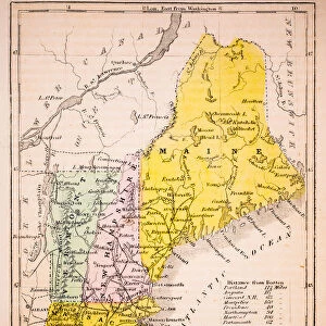
North America political map 1895

![]()
Wall Art and Photo Gifts from Fine Art Storehouse
North America political map 1895
Meyers Konversations-Lexikon. Ein Nachschlagewerk des allgemeinen Wissens, 5th edition 17 volumes Bibliographisches Institut - Leipzig 1895-1897
Unleash your creativity and transform your space into a visual masterpiece!
THEPALMER
Media ID 13611749
© This content is subject to copyright
Atlas Mythological Figure Canada Mexico North America Paper World Map
FEATURES IN THESE COLLECTIONS
> Fine Art Storehouse
> The Magical World of Illustration
> Palmer Illustrated Collection
> Fine Art Storehouse
> Map
> Historical Maps
> Fine Art Storehouse
> Map
> USA Maps
> Maps and Charts
> Early Maps
> Maps and Charts
> World
> North America
> Canada
> Maps
> North America
> Mexico
> Maps
> North America
> United States of America
> Maps
EDITORS COMMENTS
This print showcases a remarkable piece of history - the North America political map from 1895. Taken from the renowned Meyers Konversations-Lexikon, this antique illustration offers a glimpse into the world as it was over a century ago. The intricate details and exquisite craftsmanship of this engraving are truly awe-inspiring. The map encompasses not only Canada, the United States, and Mexico but also provides an insight into the physical geography of North America during that time period. It serves as a testament to the advancements in cartography and our understanding of the world's continents. Displayed vertically on high-quality paper, this print captures every nuance and intricacy of its original form. Its vintage charm adds character to any space, making it an ideal addition for history enthusiasts or those seeking unique decorative pieces with cultural significance. As you gaze upon this mesmerizing artwork by THEPALMER, let your imagination wander back to an era when exploration and discovery shaped our understanding of North America. Whether displayed in your home or office, this stunning depiction is sure to spark conversations about our continent's rich past while reminding us how far we have come in mapping our world.
MADE IN THE USA
Safe Shipping with 30 Day Money Back Guarantee
FREE PERSONALISATION*
We are proud to offer a range of customisation features including Personalised Captions, Color Filters and Picture Zoom Tools
SECURE PAYMENTS
We happily accept a wide range of payment options so you can pay for the things you need in the way that is most convenient for you
* Options may vary by product and licensing agreement. Zoomed Pictures can be adjusted in the Cart.