Home > Europe > United Kingdom > England > Hampshire > Canada
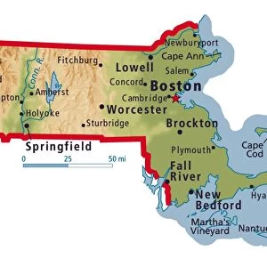
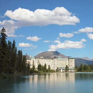
New England 1852 Map

![]()
Wall Art and Photo Gifts from Fine Art Storehouse
New England 1852 Map
Unleash your creativity and transform your space into a visual masterpiece!
benoitb
Media ID 13666919
© benoitb
Atlantic Ocean Color Swatch Connecticut East Coast Geographic Map Line Art Long Island Sound Maine Massachusetts New England Usa New Hampshire Rhode Island Sketch State The Americas Us State Border Vermont Classical Style Drawing Art Product Lower Canada New Brunswick Canada Painted Image Retro Styled Victorian Style
FEATURES IN THESE COLLECTIONS
> Arts
> Landscape paintings
> Waterfall and river artworks
> River artworks
> Europe
> France
> Canton
> Maine
> Europe
> United Kingdom
> England
> Hampshire
> Canada
> Europe
> United Kingdom
> England
> Lakes
> Europe
> United Kingdom
> England
> Maps
> Europe
> United Kingdom
> England
> Rivers
> Fine Art Storehouse
> Map
> Historical Maps
> Fine Art Storehouse
> Map
> USA Maps
> Maps and Charts
> Early Maps
> North America
> Canada
> Lakes
> Related Images
> North America
> Canada
> Maps
EDITORS COMMENTS
This print takes us back to the enchanting era of 19th-century New England. The "New England 1852 Map" is a true masterpiece that beautifully captures the essence of cartography in a retro-styled manner. With its intricate details and classical style, this painted image transports us to a time when exploration and discovery were at their peak. The artist's skillful use of line art and engraving techniques brings forth an antique charm that evokes feelings of nostalgia. Every stroke on this illustration tells a story, depicting the physical geography of New England with precision and elegance. From the majestic Long Island Sound to the meandering rivers and serene lakes, every feature is meticulously portrayed. As we gaze upon this print, our eyes are drawn towards each state within New England - Massachusetts, Connecticut, Rhode Island, Vermont, Maine, and New Hampshire - forming an interconnected tapestry rich in history. Beyond these borders lie both Lower Canada and New Brunswick in Canada as well as the vast Atlantic Ocean. With its vibrant color swatches carefully chosen by the artist's hand, this piece becomes more than just a map; it transforms into a work of art that captivates our imagination. It serves as a reminder of how far we have come while honoring the legacy left behind by those who paved our way through uncharted territories. Benoitb's "New England 1852 Map" is not merely an engraving or drawing but rather an embodiment of curiosity and exploration captured on paper for all
MADE IN THE USA
Safe Shipping with 30 Day Money Back Guarantee
FREE PERSONALISATION*
We are proud to offer a range of customisation features including Personalised Captions, Color Filters and Picture Zoom Tools
SECURE PAYMENTS
We happily accept a wide range of payment options so you can pay for the things you need in the way that is most convenient for you
* Options may vary by product and licensing agreement. Zoomed Pictures can be adjusted in the Cart.