Home > Arts > Artists > I > Indian School Indian School
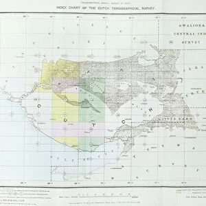
Geological Map of the Cutch Desert, 1870 (colour litho)
")
![]()
Wall Art and Photo Gifts from Fine Art Finder
Geological Map of the Cutch Desert, 1870 (colour litho)
XCF306006 Geological Map of the Cutch Desert, 1870 (colour litho) by English School, (19th century); Private Collection; English, out of copyright
Media ID 18254897
© Private Collection / Bridgeman Images
Boundaries Boundary British Empire Colony Geographic Geographical Geology Gulf Mapping Rann Region State Territory Kutch
FEATURES IN THESE COLLECTIONS
> Animals
> Mammals
> Muridae
> Desert Mouse
> Arts
> Artists
> I
> Indian School Indian School
> Asia
> Related Images
> Fine Art Finder
> Schools
> English School
> Maps and Charts
> British Empire Maps
> Maps and Charts
> Geological Map
> Maps and Charts
> Related Images
EDITORS COMMENTS
This print showcases the "Geological Map of the Cutch Desert, 1870" created by an English School artist in the 19th century. The map, a stunning example of color lithography, is part of a private collection and is now out of copyright. The intricate details depicted on this map offer a fascinating glimpse into the geological makeup of the Cutch Desert, located in Asia. As we explore its contours and boundaries, we are transported back to a time when cartography played a crucial role in understanding our world. Within this map lies not only geographical information but also traces of history and colonial influence. It serves as a testament to the British Empire's presence during that era, showcasing their interest in mapping territories across their vast dominions. The topography displayed here reveals how nature has shaped this region over centuries. From rugged mountains to sprawling plains and arid deserts, every feature tells its own story about the land's formation. As we delve deeper into this visual representation, it becomes evident that maps like these were essential tools for exploration and resource management during colonial times. They provided valuable insights into potential trade routes or areas rich in natural resources. This photograph print invites us to appreciate both artistry and scientific precision while reflecting on how geography intertwines with history and politics. It offers an opportunity to immerse ourselves in an age-old tradition where knowledge was meticulously recorded through beautiful works such as this one.
MADE IN THE USA
Safe Shipping with 30 Day Money Back Guarantee
FREE PERSONALISATION*
We are proud to offer a range of customisation features including Personalised Captions, Color Filters and Picture Zoom Tools
SECURE PAYMENTS
We happily accept a wide range of payment options so you can pay for the things you need in the way that is most convenient for you
* Options may vary by product and licensing agreement. Zoomed Pictures can be adjusted in the Cart.