Home > North America > United States of America > Maps
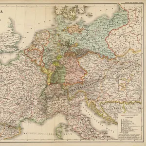
Perspective map showing the location of the North Sea Mine Barrage, the scene of the principal naval actions, and the German naval bases (colour litho)
")
![]()
Wall Art and Photo Gifts from Fine Art Finder
Perspective map showing the location of the North Sea Mine Barrage, the scene of the principal naval actions, and the German naval bases (colour litho)
3626858 Perspective map showing the location of the North Sea Mine Barrage, the scene of the principal naval actions, and the German naval bases (colour litho) by English School, (20th century); Private Collection; (add.info.: Perspective map showing the location of the North Sea Mine Barrage, the scene of the principal naval actions, and the German naval bases. Illustration for Harpers Pictorial Library of the World War, c 1920.); © Look and Learn
Media ID 22732542
© Look and Learn / Bridgeman Images
Battle Of Jutland Mines Naval Warfare North Sea 1914 1918 Great War War Scene War Zone
FEATURES IN THESE COLLECTIONS
> Arts
> Artists
> Related Images
> Europe
> United Kingdom
> Maps
> Fine Art Finder
> Artists
> English School
> Fine Art Finder
> Artists
> Newell Convers (after) Wyeth
> Historic
> World War I and II
> Naval warfare
> Historic
> World War I and II
> World War I
> Historic
> World War I and II
> Maps and Charts
> Related Images
> Maps and Charts
> World
> North America
> United States of America
> Maps
EDITORS COMMENTS
This vibrant and detailed perspective map captures the location of the North Sea Mine Barrage during World War I, showcasing the principal naval actions and German naval bases. Created by an English School artist in the 20th century, this colour lithograph is part of a private collection. The map was originally produced as an illustration for Harper's Pictorial Library of the World War around 1920. It provides a visual representation of significant battles such as the Battle of Jutland, Battle of Heligoland Bight, and Battle of Dogger Bank. The strategic importance of these locations is evident as they were key areas where intense naval warfare took place. Notably, this map highlights both British and German involvement in these conflicts. It offers insight into the positioning and distribution of mines across the North Sea Mine Barrage, which played a crucial role in disrupting enemy shipping routes. With its rich historical context, this print serves as a valuable resource for understanding World War I from a naval perspective. Its inclusion in Harper's Pictorial Library attests to its significance at that time. Overall, this artwork sheds light on one aspect of wartime strategy while also providing glimpses into European history during this tumultuous period.
MADE IN THE USA
Safe Shipping with 30 Day Money Back Guarantee
FREE PERSONALISATION*
We are proud to offer a range of customisation features including Personalised Captions, Color Filters and Picture Zoom Tools
SECURE PAYMENTS
We happily accept a wide range of payment options so you can pay for the things you need in the way that is most convenient for you
* Options may vary by product and licensing agreement. Zoomed Pictures can be adjusted in the Cart.