Canvas Print > Europe > United Kingdom > England > Maps
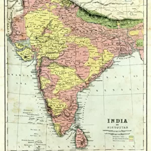
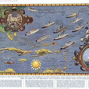
Canvas Print : Development of the British Empire, lithograph, published 1897


![]()
Canvas Prints from Fine Art Storehouse
Development of the British Empire, lithograph, published 1897
Map of the territorial development of the British Empire from the 17th century to the end of the 19th century. Lithograph, published in 1897
Unleash your creativity and transform your space into a visual masterpiece!
Media ID 15387303
© This content is subject to copyright
17th Century 18th Century America Australia British Culture British Empire Brown Central America Colonial Colonization Colony Empire English Culture India Latin America North America South Africa South America Topographic Map World Map Multi Colored Victorian Era White Color
20"x16" (51x41cm) Canvas Print
Step back in time and explore the rich history of the British Empire with our stunning Canvas Print from Media Storehouse's Fine Art Collection. This captivating lithograph, published in 1897, showcases the development of the British Empire from the 17th century to the end of the 19th century. Each detail on this map is meticulously rendered, transporting you to an era of exploration, growth, and global influence. Hang this beautiful piece in your home or office to add a touch of history and sophistication to any space.
Delivered stretched and ready to hang our premium quality canvas prints are made from a polyester/cotton blend canvas and stretched over a 1.25" (32mm) kiln dried knot free wood stretcher bar. Packaged in a plastic bag and secured to a cardboard insert for safe transit.
Canvas Prints add colour, depth and texture to any space. Professionally Stretched Canvas over a hidden Wooden Box Frame and Ready to Hang
Estimated Product Size is 50.8cm x 40.6cm (20" x 16")
These are individually made so all sizes are approximate
Artwork printed orientated as per the preview above, with landscape (horizontal) orientation to match the source image.
FEATURES IN THESE COLLECTIONS
> Africa
> Related Images
> Africa
> South Africa
> Maps
> Africa
> South Africa
> Related Images
> Arts
> Landscape paintings
> Landscape art
> Landscape paintings
> Asia
> India
> Related Images
> Asia
> Related Images
> Europe
> Related Images
> Europe
> United Kingdom
> England
> Maps
> Europe
> United Kingdom
> England
> Posters
> Fine Art Storehouse
> Map
> Historical Maps
EDITORS COMMENTS
This lithograph, published in 1897, offers a visual journey through the remarkable territorial expansion of the British Empire. Spanning from the 17th century to the end of the 19th century, this topographic map showcases the vast extent of British colonization across continents and oceans. The intricate details and vibrant colors bring to life an era defined by exploration and conquest. From Europe to America, North and South America to Latin America, Central Africa to South Africa, India to Asia, and even Australia - this map encapsulates centuries of history within its horizontal landscape. As we gaze upon this print, we are transported back in time - witnessing how England's influence shaped cultures around the world. The brown hues symbolize land conquered while blue signifies territories claimed by sea power. It is a testament not only to Britain's military might but also their enduring cultural impact. This lithograph serves as a reminder of both triumphs and controversies associated with colonialism during that period. It invites us to reflect on historical events that have shaped our present-day global landscape. A true treasure for history enthusiasts or anyone seeking insight into British culture and its imperial legacy; it stands as a testament to human ambition and exploration amidst an ever-changing world.
MADE IN THE USA
Safe Shipping with 30 Day Money Back Guarantee
FREE PERSONALISATION*
We are proud to offer a range of customisation features including Personalised Captions, Color Filters and Picture Zoom Tools
SECURE PAYMENTS
We happily accept a wide range of payment options so you can pay for the things you need in the way that is most convenient for you
* Options may vary by product and licensing agreement. Zoomed Pictures can be adjusted in the Cart.