Home > Arts > Artists > C > Calopodio da Candia
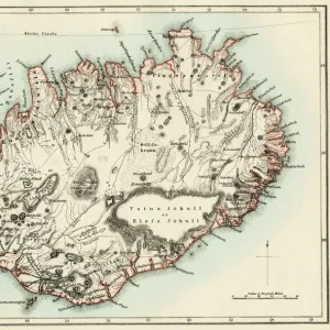
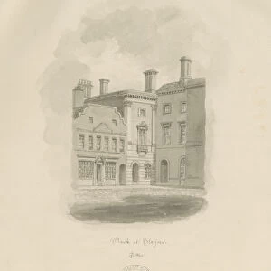
Nautical chart showing Iceland from Nautical Atlas by Giorgio Sideri

![]()
Wall Art and Photo Gifts from Universal Images Group (UIG)
Nautical chart showing Iceland from Nautical Atlas by Giorgio Sideri
Cartography, 16th century. Nautical chart from the Nautical Atlas by Giorgio Sideri known as Callapoda or Calopodio da Candia. Details of Iceland
Universal Images Group (UIG) manages distribution for many leading specialist agencies worldwide
Media ID 9502095
© DEA / A. DAGLI ORTI
17th Century Aerial View Atlas Canoe Coastline Direction Guidance House Human Settlement Iceland Journey Lake Mountain Mountain Range Nautical Vessel Navigational Equipment River Rowing Boat Small Boat Text Transportation Two People Unrecognizable Person Using A Paddle Non Urban Scene
FEATURES IN THESE COLLECTIONS
> Aerial Photography
> Iceland
> Architecture
> Country
> Iceland
> Arts
> Art Movements
> Landscapes
> Arts
> Artists
> C
> Calopodio da Candia
> Arts
> Contemporary art
> Landscapes
> Sculptures
> Arts
> Contemporary art
> Sculpture
> Landscape paintings
> Arts
> Landscape paintings
> Landscape art
> Landscape paintings
> Arts
> Landscape paintings
> Landscape art
> Nature-inspired artwork
> Arts
> Landscape paintings
> Landscape art
> Universal Images Group (UIG)
> Art
> Painting, Sculpture & Prints
> Cartography
EDITORS COMMENTS
This print showcases a remarkable nautical chart from the 16th century, depicting Iceland's intricate details. Created by the renowned cartographer Giorgio Sideri, also known as Callapoda or Calopodio da Candia, this historical piece offers a glimpse into the past world of navigation and exploration. The image portrays a vast expanse of nature, with mountains towering over a serene lake. A small rowing boat can be seen gliding through the calm waters, guided by two unrecognizable individuals using paddles. The topography of Iceland is meticulously illustrated on the map, providing valuable guidance for seafarers during that era. This aerial view captures not only the physical geography but also highlights human settlements and architectural structures along the coastline. It serves as a testament to mankind's quest for discovery and adventure in an age when transportation relied heavily on nautical vessels. The artistry displayed in this painting reflects both skillful craftsmanship and meticulous attention to detail. As we admire this historic artifact, it transports us back in time to an era where maps were essential tools for explorers embarking on daring journeys across uncharted territories. With its rich history and stunning depiction of Iceland's landscape, this print invites us to appreciate how far we have come in our understanding of cartography while reminding us of our innate curiosity about distant lands and cultures.
MADE IN THE USA
Safe Shipping with 30 Day Money Back Guarantee
FREE PERSONALISATION*
We are proud to offer a range of customisation features including Personalised Captions, Color Filters and Picture Zoom Tools
SECURE PAYMENTS
We happily accept a wide range of payment options so you can pay for the things you need in the way that is most convenient for you
* Options may vary by product and licensing agreement. Zoomed Pictures can be adjusted in the Cart.