Home > Arts > Artists > H > Franz Hogenberg
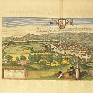
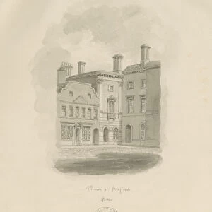
Map of Ostend from Civitates Orbis Terrarum by Georg Braun, 1541-1622 and Franz Hogenberg, 1540-1590, engraving

![]()
Wall Art and Photo Gifts from Universal Images Group (UIG)
Map of Ostend from Civitates Orbis Terrarum by Georg Braun, 1541-1622 and Franz Hogenberg, 1540-1590, engraving
Cartography, Belgium, 16th century. Map of Ostend. From Civitates Orbis Terrarum by Georg Braun (1541-1622) and Franz Hogenberg (1540-1590), Cologne. Engraving
Universal Images Group (UIG) manages distribution for many leading specialist agencies worldwide
Media ID 9500583
© DEA / R. MERLO
16th Century Belgium Coat Of Arms Elevated View Island Latin Script Manuscript Sailing Boat Townscape Ostend
FEATURES IN THESE COLLECTIONS
> Arts
> Art Movements
> Landscapes
> Arts
> Artists
> H
> Franz Hogenberg
> Arts
> Contemporary art
> Landscapes
> Sculptures
> Arts
> Contemporary art
> Sculpture
> Landscape paintings
> Arts
> Landscape paintings
> Landscape art
> Landscape paintings
> Arts
> Landscape paintings
> Landscape art
> Europe
> Belgium
> Paintings
> Europe
> Belgium
> Sculptures
> Universal Images Group (UIG)
> Art
> Painting, Sculpture & Prints
> Cartography
EDITORS COMMENTS
This print showcases a remarkable piece of cartographic history - the Map of Ostend from Civitates Orbis Terrarum. Created by Georg Braun and Franz Hogenberg in the 16th century, this engraving offers a fascinating glimpse into the coastal town of Ostend in Belgium. The map, meticulously crafted with intricate details, transports us back to an era when sailing boats ruled the seas and townscape architecture defined urban landscapes. The elevated view allows us to appreciate the physical geography of Ostend, surrounded by vast stretches of sea that were once traversed by adventurous sailors. In this studio shot, we can marvel at every stroke and line etched onto this manuscript-like artwork. The Latin script adds an air of authenticity and historical significance to this masterpiece. Notably, the coat of arms proudly displayed on the map symbolizes Ostend's rich heritage and its place within Belgian history. This horizontal composition invites viewers to explore every corner of this ancient town through Braun and Hogenberg's artistic vision. As an illustration and painting combined, this artful engraving captures our imagination as we envision life in 16th-century Ostend. It serves as a testament to human curiosity about distant lands and our innate desire for exploration
MADE IN THE USA
Safe Shipping with 30 Day Money Back Guarantee
FREE PERSONALISATION*
We are proud to offer a range of customisation features including Personalised Captions, Color Filters and Picture Zoom Tools
SECURE PAYMENTS
We happily accept a wide range of payment options so you can pay for the things you need in the way that is most convenient for you
* Options may vary by product and licensing agreement. Zoomed Pictures can be adjusted in the Cart.