Home > Arts > Artists > A > Battista Agnese
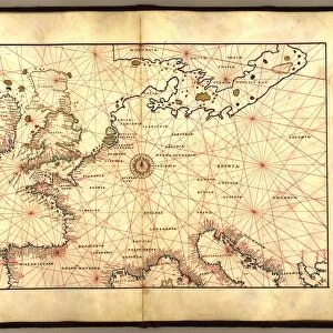
Map of Northern Europe, from Portolan Atlas by Battista Agnese, 1553

![]()
Wall Art and Photo Gifts from Universal Images Group (UIG)
Map of Northern Europe, from Portolan Atlas by Battista Agnese, 1553
Cartography, 16th century. Map of Northern Europe, from the Portolan Atlas by Battista Agnese, 1553
Universal Images Group (UIG) manages distribution for many leading specialist agencies worldwide
Media ID 9503015
© DEA PICTURE LIBRARY
16th Century Baltic Sea Geography Guidance Island Northern Europe
FEATURES IN THESE COLLECTIONS
> Arts
> Artists
> A
> Battista Agnese
> Europe
> Related Images
> Universal Images Group (UIG)
> Art
> Painting, Sculpture & Prints
> Cartography
EDITORS COMMENTS
This print showcases a remarkable piece of cartographic history - the "Map of Northern Europe" from the Portolan Atlas by Battista Agnese, dating back to 1553. A true testament to the artistry and precision of 16th-century mapmaking, this image transports us back in time to an era when exploration and navigation were at their peak. The map itself is a visual feast for geography enthusiasts, offering a detailed depiction of Northern Europe's vast expanse. From the Baltic Sea to its surrounding islands, every contour and coastline has been meticulously illustrated with utmost accuracy. The horizontal layout allows viewers to immerse themselves in this historical journey, tracing trade routes and imagining epic sea voyages that once took place across these waters. As we delve into this ancient masterpiece, it becomes evident that beyond its aesthetic appeal lies a practical purpose - guidance for sailors navigating treacherous seas. This map served as an invaluable tool for mariners seeking safe passage through unfamiliar territories; its intricate details providing essential knowledge about coastal features and potential hazards. Battista Agnese's expertise shines through his craftsmanship, showcasing his mastery in blending artistry with scientific precision. Although void of human presence, this image speaks volumes about our collective past - reminding us of the rich heritage embedded within maps like these. In preserving such historical treasures like this Map of Northern Europe, we gain not only insight into our ancestors' world but also appreciation for the evolution of cartography as both an artistic expression and vital navig
MADE IN THE USA
Safe Shipping with 30 Day Money Back Guarantee
FREE PERSONALISATION*
We are proud to offer a range of customisation features including Personalised Captions, Color Filters and Picture Zoom Tools
SECURE PAYMENTS
We happily accept a wide range of payment options so you can pay for the things you need in the way that is most convenient for you
* Options may vary by product and licensing agreement. Zoomed Pictures can be adjusted in the Cart.