Home > Science > Space Exploration > Planets > Earth
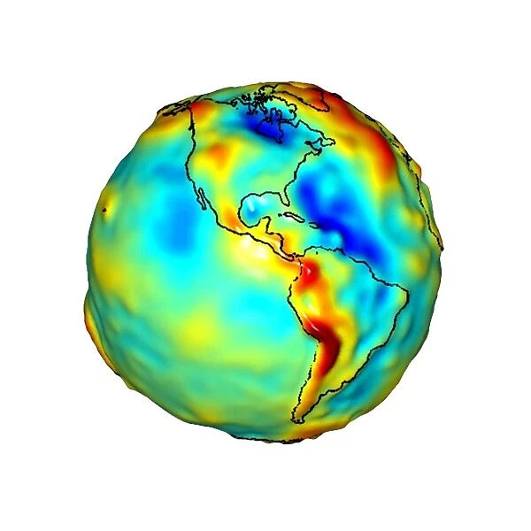
Gravity map of Earth C018 / 9374
![]()

Wall Art and Photo Gifts from Science Photo Library
Gravity map of Earth C018 / 9374
Gravity map of Earth. Computer model showing the variation of the Earths gravity field centred on the Americas. Colours represent gravity anomaly. These are the differences between the theoretical value for the gravity at the surface, if the Earth was a perfectly smooth ellipsoid, and the actual measured value. They range from blue (low gravity), through green, yellow, orange and red (high gravity). This model was created from data acquired by NASAs Gravity Recovery and Climate Experiment (GRACE). An accurate gravity map enables scientists to better understand the Earths internal structure and may help predict climate change and natural hazards
Science Photo Library features Science and Medical images including photos and illustrations
Media ID 9250039
© NASA/JPL/University of Texas Center for Space Research/SCIENCE PHOTO LIBRARY
Americas Astrophysical Astrophysics Earth Observation Geodesy Global Globe Grace Gravity Gravity Map Latin America Mass North American South America Cutouts
FEATURES IN THESE COLLECTIONS
> Science
> Scientists
> Science
> Space Exploration
> Planets
> Earth
EDITORS COMMENTS
This print showcases a gravity map of Earth, specifically focusing on the Americas. The computer model beautifully illustrates the variation in Earth's gravity field, with colors representing gravity anomalies. These anomalies indicate the differences between the theoretical value for surface gravity if our planet were a perfectly smooth ellipsoid and the actual measured values. Ranging from blue (low gravity) to red (high gravity), these variations provide crucial insights into Earth's internal structure. Created using data acquired by NASA's Gravity Recovery and Climate Experiment (GRACE), this accurate gravity map holds immense significance for scientists worldwide. By better understanding our planet's gravitational forces, researchers can delve deeper into its mysteries and gain valuable knowledge about climate change predictions and natural hazards. The white background enhances the clarity of this image, allowing viewers to focus solely on Earth as a whole. With North America at its center, it encompasses both North and Latin America, providing an encompassing view of these continents' gravitational characteristics. This remarkable print is not just visually stunning but also serves as a testament to humanity's continuous exploration of astrophysics and geodesy. It reminds us that through cutting-edge technology like GRACE, we are unraveling more secrets about our home planet every day.
MADE IN THE USA
Safe Shipping with 30 Day Money Back Guarantee
FREE PERSONALISATION*
We are proud to offer a range of customisation features including Personalised Captions, Color Filters and Picture Zoom Tools
SECURE PAYMENTS
We happily accept a wide range of payment options so you can pay for the things you need in the way that is most convenient for you
* Options may vary by product and licensing agreement. Zoomed Pictures can be adjusted in the Cart.

