Fraud Blocker Skip to main content

Global Collection

Background imageGlobal Collection: Al-Idrisis world map, 1154

Al-Idrisis world map, 1154
Al-Idrisis world map. This world map, known as the Tabula Rogeriana, dates from 1154, and is orientated with North at bottom

Background imageGlobal Collection: Whole Earth at night, satellite image

Whole Earth at night, satellite image
Whole Earth map at night, satellite image. Here, Africa is seen at centre

Background imageGlobal Collection: Continental drift after 250 million years

Continental drift after 250 million years, showing the supercontinent of Pangea Ultima, which was named for the ancient supercontinent of Pangea

Background imageGlobal Collection: Oronce Fines world map, 1531

Oronce Fines world map, 1531
Oronce Fines world map. Map of the worlds northern and southern hemispheres by the French mathematician and cartographer Oronce Fine (1494-1555)

Background imageGlobal Collection: British Prime Minister Winston Churchill V for victory salut

British Prime Minister Winston Churchill V for victory salut
British Prime Minister Winston Churchill making his V for victory salute

Background imageGlobal Collection: WW II - Princess Elizabeth working as a mechanic

WW II - Princess Elizabeth working as a mechanic
World War II - Princess Elizabeth, later Queen Elizabeth 2nd training as a secoond subaltern in the ATS - working as a mechanic, taking out the plugs of a car

Background imageGlobal Collection: Europe at night, satellite image

Europe at night, satellite image. City lights (yellow) of increasing intensity show areas of increasing population, with areas of few lights being more sparsely populated

Background imageGlobal Collection: Earth, topographic and bathymetric map

Earth, topographic and bathymetric map. This whole Earth map is centred on the Greenwich meridian, at zero degrees latitude

Background imageGlobal Collection: Earth

Earth. Satellite image of the Earth, centred on Antarctica. The South Pole is at centre. Water is blue, vegetation is green, arid areas are brown, and snow and ice are white

Background imageGlobal Collection: WW II - Admiral Karl Doenitz Donitz, German navy

WW II - Admiral Karl Doenitz Donitz, German navy
Vintage photograph World War II - Admiral Karl Doenitz Donitz, German navy

Background imageGlobal Collection: Earths tectonic plates

Earths tectonic plates. Global map showing the boundaries of the tectonic plates that make up the Earths crust

Background imageGlobal Collection: Marsden Rock

Marsden Rock
Marden Rock, near South Shields, County Durham, England. Date: BC

Background imageGlobal Collection: Pan American Airways route map

Pan American Airways route map
Pan American Airways System global route map of the Flying Clipper Ships (passengers, mail, express). circa 1938

Background imageGlobal Collection: The Tatler travel number front cover, 1953

The Tatler travel number front cover, 1953
Charming illustrated front cover of The Tatlers Travel number showing a number of well-known global landmarks with various intrepid travellers using a multitude of transport methods. Date: 1953

Background imageGlobal Collection: Continental drift, 100 million years ago

Continental drift, 100 million years ago

Background imageGlobal Collection: Wine, growing countries (colour litho)

Wine, growing countries (colour litho)
3648621 Wine, growing countries (colour litho) by English School, (20th century); Private Collection; (add.info.: Wine, growing countries)

Background imageGlobal Collection: Computer graphic of global internet traffic

Computer graphic of global internet traffic
Internet traffic. Computer graphic of global internet traffic. Each line represents the path of sample data sent out to one of 20, 000 pre- selected locations using a system called Skitter

Background imageGlobal Collection: Earth, topographic and bathymetric map

Earth, topographic and bathymetric map. This map is centred on the Pacific Ocean, at longitude 140 degrees west

Background imageGlobal Collection: Continuous Earth line drawing symbol

Continuous Earth line drawing symbol. World map one line art. Earth globe hand drawn insignia

Background imageGlobal Collection: Wiley Post with Racing Plane

Wiley Post with Racing Plane
(Original Caption) 6/15/1933-Floyd Bennett Field, NY- Wiley Post, famous round-the-world flier, is shown in front of his globe-girdling plane, Winnie Mae, after his arrival at Floyd Bennett Field

Background imageGlobal Collection: Jesse Owens and Luz Long Watch Olympics

Jesse Owens and Luz Long Watch Olympics
Competitors Luz Long and Jesse Owens seem very amicable watching contestants in the broad jump

Background imageGlobal Collection: Whole Earth, satellite image

Whole Earth, satellite image. This map is centred on the Greenwich meridian, at zero degrees latitude. Arctic and Antarctic ice is white, oceans are blue and land is green and brown

Background imageGlobal Collection: Single tree in Sahara Desert, Algeria

Single tree in Sahara Desert, Algeria

Background imageGlobal Collection: WW II - partly assembled Focke-Wulf 190 Bremen factory

WW II - partly assembled Focke-Wulf 190 Bremen factory
Vintage photograph World War II - partly assembled Focke-Wulf 190 aircraft in the companys Bremen factory, following RAF bombing

Background imageGlobal Collection: Advert, Nippon Yusen Kaisha, Japan Mail Steamship Co Ltd

Advert, Nippon Yusen Kaisha, Japan Mail Steamship Co Ltd
Advert for NYK, Nippon Yusen Kaisha, Japan Mail Steamship Co Ltd, Passenger Line. 1905

Background imageGlobal Collection: Cunard Line poster

Cunard Line poster
Fabulously detailed poster for Cunard Line shipping company showing a passenger liner in cross-section with cabins and rooms visible on various decks

Background imageGlobal Collection: Tank of Allied armies in front of Cologne Cathedral, Germany

Tank of Allied armies in front of Cologne Cathedral, Germany
Tank of the Allied armies in front of Cologne Cathedral, Germany, towards the end of world War II

Background imageGlobal Collection: Planet Earth on human hands, breaking down and crumbling

Planet Earth on human hands, breaking down and crumbling with fragments falling apart. Airbrush illustration

Background imageGlobal Collection: World War II B25 bomber attacks Japanese ship

World War II B25 bomber attacks Japanese ship
World War II vintage photograph - B25 bomber attacks Japanese ship in China Sea

Background imageGlobal Collection: Vintage photograph WW II - British Churchill tank

Vintage photograph WW II - British Churchill tank
Vintage photograph World War II - British Churchill tank, Italian campaign, crossing of the Senio River

Background imageGlobal Collection: Venus from space, artwork C017 / 7375

Venus from space, artwork C017 / 7375
Venus from space. Computer artwork of the planet Venus. Venus is the second planet from the Sun. It is both the closest planet to Earth and the closest to Earth in size

Background imageGlobal Collection: World map, February 2004

World map, February 2004
World Map. Blue Marble: Next Generation cloud-free true-colour composite image of the Earth in February 2004

Background imageGlobal Collection: New York, NY, USA. 10 June, 2010

New York, NY, USA. 10 June, 2010. Playboy playmate Miss November 2001, Lindsey Vuolo at the 50th anniversary of the Playboy Club & Playboy Bunny at Juliet Supper Club. Credit: Steve Mack/Alamy

Background imageGlobal Collection: Bombardier E-11A Global Express 11-9001

Bombardier E-11A Global Express 11-9001
United States Air Force - Bombardier E-11A Global Express 11-9001 (MSN 9001) BD-700-1A10 Global Express used as a platform for the Battlefield Airborne Communications Node. Date: circa 2015

Background imageGlobal Collection: Odawara Castle, Kanagawa, Japan, von Stillfried studio

Odawara Castle, Kanagawa, Japan, von Stillfried studio
Vintage late 19th century photograph: Odawara Castle, Kanagawa, Japan, von Stillfried studio

Background imageGlobal Collection: World War II France and Britain commemorate D-Day

World War II France and Britain commemorate D-Day
Vintage World War II photograph - France and Britain commemorate the first anniversay of the D-Day landings on the beach at Arromanches, Normandy

Background imageGlobal Collection: Route map, Imperial Airways

Route map, Imperial Airways. 1938

Background imageGlobal Collection: Map of Kosice

Map of Kosice
Antique illustration of a map of Kosice

Background imageGlobal Collection: Fully lit Earth centered on the North Pole

Fully lit Earth centered on the North Pole

Background imageGlobal Collection: A 3D conceptual image of the world at your fingertips

A 3D conceptual image of the world at your fingertips

Background imageGlobal Collection: Global overpopulation, conceptual artwork

Global overpopulation, conceptual artwork. Map of the world made out of babies, representing the overpopulation of the Earth. Overpopulation is thought to be a major cause of climate change

Background imageGlobal Collection: Orteliuss world map, 1570

Orteliuss world map, 1570
Orteliuss world map. This world map is from the 1570 first edition of Theatrum orbis terrarum ( Theatre of the World )

Background imageGlobal Collection: Views of Mendenhall Glacier just outside Juneau

Views of Mendenhall Glacier just outside Juneau
Michael Nolan / SpecialistStock

Background imageGlobal Collection: The World In Love

The World In Love
Hanna Lee Tidd

Background imageGlobal Collection: B-24 Liberator bombers Neuberg Austria. 1945

B-24 Liberator bombers Neuberg Austria. 1945
Vintage World War II photograph - official US militaryphoto: b-24 Liberator bombers en route to drop fragmentation bombs on the airfield of Neuberg Austria. 1945

Background imageGlobal Collection: Railway bridge at Sinzig Germany, Allied bombing

Railway bridge at Sinzig Germany, Allied bombing
Vintage World War II photograph - official US military photo: damage to the railway bridge at Sinzig Germany following Allied bombing attacks

Background imageGlobal Collection: World War II transport planes & gliders ready England

World War II transport planes & gliders ready England
Vintage World War II photograph - transport planes and gliders ready for takeoff in England, for landings in the Netherlands

Background imageGlobal Collection: World War II ruins in the centre of Berlin

World War II ruins in the centre of Berlin
World War II vintage photograph - ruins in the centre of Berlin, dust cloud from collapsing wall

Background imageGlobal Collection: World War II navy ship Pacific war against Japan

World War II navy ship Pacific war against Japan
Vintage World War II photograph - navy ship releases a salvo in the Pacific war against Japan

Background imageGlobal Collection: Wilhelmshaven. Germany

Wilhelmshaven. Germany
Antique illustration of a Wilhelmshaven, Germany map

Background imageGlobal Collection: Picture No. 11050489

Picture No. 11050489
Iceberg melting iceberg drifting Arctic ocean Summer Davis Strait, Greenland, Arctic, Denmark Date:

Background imageGlobal Collection: Garden Bonfire

Garden Bonfire
Billowing smoke pollution caused by a garden bonfire. Date: 1960s

Background imageGlobal Collection: traffic congestion on the M1 motorway at Loughborough due to sheer volume of traffic with a plane coming into land at

traffic congestion on the M1 motorway at Loughborough due to sheer volume of traffic with a plane coming into land at
Ashley Cooper / SpecialistStock

Background imageGlobal Collection: Map of Australia with states, cities and flag

Map of Australia with states, cities and flag
Highly detailed vector map of Australia with states, capitals and big cities

Background imageGlobal Collection: Compass logo design with Q letter concept. Compass Concept with Q letter typography

Compass logo design with Q letter concept. Compass Concept with Q letter typography

Background imageGlobal Collection: Global environmental problems. Exhaustion of land resources infographic

Global environmental problems. Exhaustion of land resources infographic. Deforestation. Vector illustration

Background imageGlobal Collection: Cute little girl sitting at table and looking at laptop

Cute little girl sitting at table and looking at laptop

Background imageGlobal Collection: red kite glides on a wind turbine

red kite glides on a wind turbine

Background imageGlobal Collection: Money of United Arab Emirates. United Arab Emirates dirham bills

Money of United Arab Emirates. United Arab Emirates dirham bills. AED banknotes. 100 dirhams. Business, finance, news background.

Background imageGlobal Collection: Egyptian one pound banknote 1967 banknote

Egyptian one pound banknote 1967 banknote. famous ancient banknotes , vintage retro. , historic old Egyptian money

Background imageGlobal Collection: Group Of Multi-Ethnic People Social Networking

Group Of Multi-Ethnic People Social Networking

Background imageGlobal Collection: Satellite view of Jerusalem map, Israel, on gray background

Satellite view of Jerusalem map, Israel, on gray background

Background imageGlobal Collection: Satellite in front of the globe with Europe

Satellite in front of the globe with Europe, symbolic image Galileo navigation system, overhead intelligence, data transmission

Background imageGlobal Collection: 5g logo icon vector for graphic design, logo, website, social media, mobile app, UI

5g logo icon vector for graphic design, logo, website, social media, mobile app, UI

Background imageGlobal Collection: Driving simulator, car racing games

Driving simulator, car racing games, driving games at the Entertainment Area of the Gamescom, the world's largest fair for Driving simulator, car racing games

Background imageGlobal Collection: Trader and holographic data panel on crypto assets

Trader and holographic data panel on crypto assets A trader analyzes crypto assets data on a virtual holographic panel.

Background imageGlobal Collection: Arrow mouse cursor, isolated pointer icon, vector illustration.

Arrow mouse cursor, isolated pointer icon, vector illustration.
Arrow mouse cursor, isolated pointer icon, vector illustration Arrow mouse cursor, pointer icon, vector illustration

Background imageGlobal Collection: crypto wallet or digital cryptocurrency money for website design template banner or slide presentation cover vector

crypto wallet or digital cryptocurrency money for website design template banner or slide presentation cover vector illustration

Background imageGlobal Collection: Coca Cola logo on red background

Coca Cola logo on red background Coca Cola logo on red background

Background imageGlobal Collection: Collection of different types of aircrafts illustrated

Collection of different types of aircrafts illustrated

Background imageGlobal Collection: HOCHIMINH CITY, VIETNAM - MARCH 8: Ralph Lauren flagship store in Ho Chi Minh City

HOCHIMINH CITY, VIETNAM - MARCH 8: Ralph Lauren flagship store in Ho Chi Minh City, Vietnam on March 8, 2015 HOCHIMINH CITY, VIETNAM - MARCH 8: Ralph Lauren flagship store in Ho Chi Minh City

Background imageGlobal Collection: outline global earth planet geography design

outline global earth planet geography design outline global earth planet geography design vector illustration

Background imageGlobal Collection: All maps of world countries and flags

All maps of world countries and flags. Set 5 of 10. Collection of outline shape of international country map with shadow. Flat design. Vector

Background imageGlobal Collection: Malaysia and Thailand flags. 3D Waving flag design

Malaysia and Thailand flags. 3D Waving flag design. Malaysia Thailand flag, picture, wallpaper. Malaysia vs Thailand image, 3D rendering. Malaysia Thai Malaysia and Thailand flags

Background imageGlobal Collection: Stock Photo - KFC Kentucky Fried Chicken Drive Thru red sign with Colonel Sanders on roadside with blue sky

Stock Photo - KFC Kentucky Fried Chicken Drive Thru red sign with Colonel Sanders on roadside with blue sky Stock Photo - KFC Kentucky Fried Chicken Drive Thru red sign with Colonel Sanders

Background imageGlobal Collection: World Wide Junior Endeavour - Christian Movement

World Wide Junior Endeavour - Christian Movement for young people - UK. Date: circa 1920s

Background imageGlobal Collection: Black Ink Grunge Hand Drawing of City Covered by Smog and Air Pollution

Black Ink Grunge Hand Drawing of City Covered by Smog and Air Pollution Black brush and ink artistic rough hand drawing of high rise building and smog covering the city

Background imageGlobal Collection: save our planet poster

save our planet poster save our planet, world and tree poster

Background imageGlobal Collection: Wilhelm von Braumueller (b. 19 March 1807 Zillbach)

Wilhelm von Braumueller (b. 19 March 1807 Zillbach)
Wilhelm von Braumueller (b. 19 March 1807 Zillbach, d. 25 July 1884 Vienna) bookseller

Background imageGlobal Collection: Ginkgo or Ginko, Ginkgo biloba

Ginkgo or Ginko, Ginkgo biloba, a tree species native to China, now planted worldwide, illustration from 1880, Historical, digital reproduction of an original from the 19th century

Background imageGlobal Collection: Insects, breeding site and development of the letterpress beetle

Insects, breeding site and development of the letterpress beetle, spruce bark beetle, Bostrychus typographus, Historical, digitally restored reproduction from a 19th century original

Background imageGlobal Collection: Ramie, also known as China grass

Ramie, also known as China grass, true ramie, China grass, Chinese plant (Boehmeria nivea), white ramie, digitally restored reproduction of an original from the 19th century


All products are expertly crafted, using premium materials, tailored to your specifications and promptly shipped


EDITORS COMMENTS

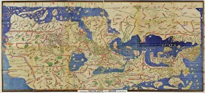
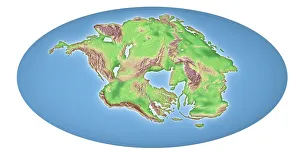
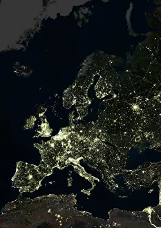
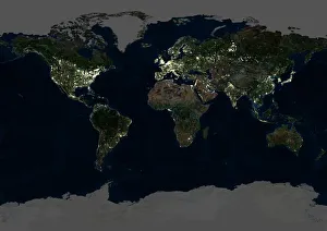
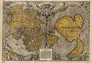
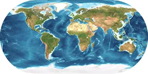
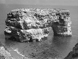
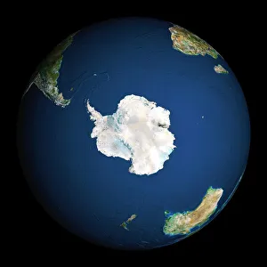
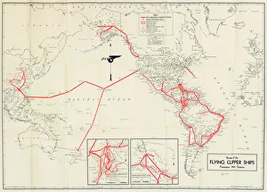
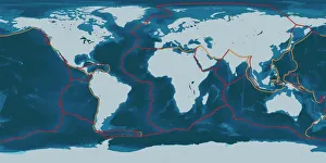
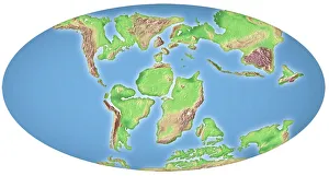
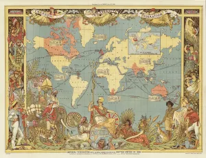
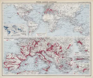
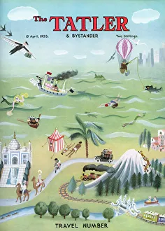
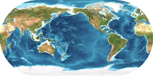
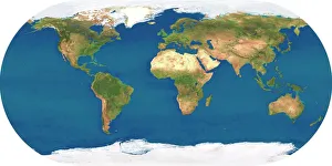
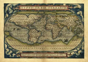
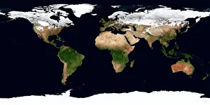
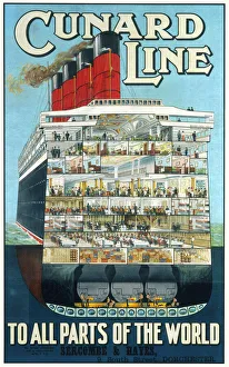
"Exploring the Global Tapestry: From Ancient Maps to Modern Marvels" Al-Idrisi's World Map, 1154: A glimpse into the early understanding of our global interconnectedness. Continental Drift after 250 Million Years: Unveiling the ever-changing nature of our planet and its geological transformations. Europe at Night, Satellite Image: Witnessing the vibrant glow of human activity across a continent that never sleeps. Whole Earth at Night, Satellite Image: Behold the breathtaking beauty of our illuminated world from space – a testament to humanity's presence on every corner. Marsden Rock: Nature's masterpiece standing tall amidst crashing waves, reminding us of Earth's awe-inspiring diversity. Oronce Fine's World Map, 1531: An artistic representation showcasing evolving cartographic knowledge during an era of exploration and discovery. Earth - Topographic and Bathymetric Map: Delving into the intricate details that shape both land and sea on our magnificent blue planet. British Prime Minister Winston Churchill V for Victory Salute: A symbol of resilience and unity in times turmoil during World War II. Imperial Federation (Colour Litho): Imagining a world where nations unite under one imperial banner – an ambitious vision from history with lasting implications today. The Tatler Travel Number Front Cover, 1953: Embarking on journeys around the globe through captivating stories and stunning visuals captured by The Tatler magazine. Pan American Airways Route Map: Tracing aviation routes connecting continents in an era when air travel revolutionized global connectivity like never before. Earth’s Tectonic Plates .

© Copyright Media Storehouse, All Rights Reserved 2003 - 2025
Facebook     Pinterest     100% Payment Secure     Reviews IO