Premium Framed Print > South America > Related Images
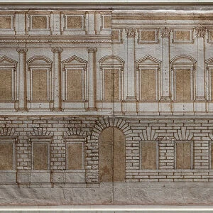
Premium Framed Print : YORKTOWN: SIEGE MAP, 1781. Map showing the British fortifications and the siege lines of the French and American forces at Yorktown, Virginia, in 1781. Watercolor drawn for General Lafayette by Major Capitaine


![]()
Framed Photos From Granger
YORKTOWN: SIEGE MAP, 1781. Map showing the British fortifications and the siege lines of the French and American forces at Yorktown, Virginia, in 1781. Watercolor drawn for General Lafayette by Major Capitaine
YORKTOWN: SIEGE MAP, 1781. Map showing the British fortifications and the siege lines of the French and American forces at Yorktown, Virginia, in 1781. Watercolor drawn for General Lafayette by Major Capitaine du Chesnoy
Granger holds millions of images spanning more than 25,000 years of world history, from before the Stone Age to the dawn of the Space Age
Media ID 6622535
1781 American Revolution Aristocratic Continental Army Gilbert Joseph Maria Marquess Motier Paul Rebellion Revolutionary Roche Siege South East Yorktown Yves
14"x18" Premium Frame
Contemporary style Premium Wooden Frame with 8"x12" Print. Complete with 2" White Mat and 1.25" thick MDF frame. Printed on 260 gsm premium paper. Glazed with shatter proof UV coated acrylic glass. Backing is paper covered backing with rubber bumpers. Supplied ready to hang with a pre-installed sawtooth/wire hanger. Care Instructions: Spot clean with a damp cloth. Securely packaged in a clear plastic bag and envelope in a reinforced cardboard shipper
FSC Real Wood Frame and Double Mounted with White Conservation Mountboard - Professionally Made and Ready to Hang
Estimated Image Size (if not cropped) is 30.4cm x 20.3cm (12" x 8")
Estimated Product Size is 45.8cm x 35.6cm (18" x 14")
These are individually made so all sizes are approximate
Artwork printed orientated as per the preview above, with landscape (horizontal) orientation to match the source image.
EDITORS COMMENTS
This print showcases a historical artifact that takes us back to the pivotal Siege of Yorktown in 1781. The watercolor map, drawn by Major Capitaine du Chesnoy for General Lafayette, provides an intricate depiction of the British fortifications and the siege lines established by French and American forces in Yorktown, Virginia. As we gaze upon this piece, we are transported to a time when America was still fighting for its independence during the Revolutionary War. The detailed representation allows us to visualize the strategic positions held by both sides as they engaged in a fierce battle for freedom. The significance of this map lies not only in its military importance but also in its connection to key figures of that era. General Lafayette, an aristocratic soldier who played a crucial role in supporting the American cause, commissioned this artwork from Major Capitaine du Chesnoy. It serves as a testament to their collaboration and dedication to securing victory against British forces. Through this image, we gain insight into the complexities of warfare during one of history's most transformative periods – the American Revolution. It reminds us of the sacrifices made by countless individuals like General Paul de Motier de Lafayette and his comrades-in-arms who fought valiantly for liberty and laid down foundations for future generations.
MADE IN THE USA
Safe Shipping with 30 Day Money Back Guarantee
FREE PERSONALISATION*
We are proud to offer a range of customisation features including Personalised Captions, Color Filters and Picture Zoom Tools
SECURE PAYMENTS
We happily accept a wide range of payment options so you can pay for the things you need in the way that is most convenient for you
* Options may vary by product and licensing agreement. Zoomed Pictures can be adjusted in the Basket.