Premium Framed Print > Fine Art Storehouse > Map
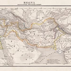
Premium Framed Print : Map of Alexanders empire and conquests


![]()
Framed Photos From Fine Art Storehouse
Map of Alexanders empire and conquests
Antique illustration Map of Alexanders empire and conquests
Unleash your creativity and transform your space into a visual masterpiece!
Nastasic
Media ID 13590333
© This content is subject to copyright
Alexander The Great Armed Forces Cartographer Chart Country Geographic Area Diagram Empire Geographical Locations Local Landmark Military Plan Serbia Us Military World Map Drawing Art Product
14"x16" Premium Frame
Contemporary style Premium Wooden Frame with 8"x10" Print. Complete with 2" White Mat and 1.25" thick MDF frame. Printed on 260 gsm premium paper. Glazed with shatter proof UV coated acrylic glass. Backing is paper covered backing with rubber bumpers. Supplied ready to hang with a pre-installed sawtooth/wire hanger. Care Instructions: Spot clean with a damp cloth. Securely packaged in a clear plastic bag and envelope in a reinforced cardboard shipper
FSC Real Wood Frame and Double Mounted with White Conservation Mountboard - Professionally Made and Ready to Hang
Estimated Image Size (if not cropped) is 25.4cm x 20.3cm (10" x 8")
Estimated Product Size is 40.6cm x 35.6cm (16" x 14")
These are individually made so all sizes are approximate
Artwork printed orientated as per the preview above, with landscape (horizontal) orientation to match the source image.
FEATURES IN THESE COLLECTIONS
> Fine Art Storehouse
> Legends and Icons
> Famous Military Leaders
> Alexander the Great (356 bc-323 bc)
> Fine Art Storehouse
> The Magical World of Illustration
> Nastasic Images & Illustrations
> Fine Art Storehouse
> Map
> Historical Maps
EDITORS COMMENTS
This antique illustration print showcases a detailed "Map of Alexander's Empire and Conquests" taking us back in time to the remarkable reign of Alexander the Great. The horizontal composition allows for an immersive exploration of this historical masterpiece, measuring 672806484 geographical locations across various countries and kingdoms. The artist, Nastasic, skillfully brings history to life through their intricate drawing art product. Every line and stroke on this map signifies the vastness of Alexander's empire and his military triumphs. As we study this engraving, we can almost envision the armed forces marching across these lands, conquering one local landmark after another. Created in the 19th century, this illustration exemplifies exceptional cartography skills as it meticulously outlines each country geographic area within Alexander's domain. It serves not only as a visual representation but also as a valuable educational tool for those interested in world history. With its rich colors and expertly crafted illustration technique, this artwork is more than just a map; it is a testament to human ambition and conquest. Whether you are an avid traveler or simply fascinated by ancient civilizations, having this piece adorning your walls will transport you back to an era where empires were built with bravery and determination.
MADE IN THE USA
Safe Shipping with 30 Day Money Back Guarantee
FREE PERSONALISATION*
We are proud to offer a range of customisation features including Personalised Captions, Color Filters and Picture Zoom Tools
SECURE PAYMENTS
We happily accept a wide range of payment options so you can pay for the things you need in the way that is most convenient for you
* Options may vary by product and licensing agreement. Zoomed Pictures can be adjusted in the Basket.