Fraud Blocker Skip to main content

Country Geographic Area Collection

"Exploring the World

Background imageCountry Geographic Area Collection: Sunrise with Angkor Wat, Siem Reap, Cambodia

Sunrise with Angkor Wat, Siem Reap, Cambodia

Background imageCountry Geographic Area Collection: Map of Portugal

Map of Portugal
Antique illustration engraving map og Portugal

Background imageCountry Geographic Area Collection: China map

China map
illustration of a South Eastern Asia map

Background imageCountry Geographic Area Collection: Highly detailed USA Road Map

Highly detailed USA Road Map
Highly detailed map of United States with roads, states, big cities, rivers and some other objects

Background imageCountry Geographic Area Collection: Costa Rica Vector Map

Costa Rica Vector Map
+++

Background imageCountry Geographic Area Collection: Austro-Hungarian Empire, Habsburg Monarchy, lithograph, published in 1877

Austro-Hungarian Empire, Habsburg Monarchy, lithograph, published in 1877
Ancient map of Austro-Hungarian Empire. Habsburg Monarchy. Lithograph, published in 1877

Background imageCountry Geographic Area Collection: Bosnia, dalmatia, istria, croatia, slavonia

Bosnia, dalmatia, istria, croatia, slavonia
Antique illustration of a Bosnia, dalmatia, istria, croatia, slavonia map

Background imageCountry Geographic Area Collection: Sunrise with Angkor Wat, Siem Reap, Cambodia

Sunrise with Angkor Wat, Siem Reap, Cambodia

Background imageCountry Geographic Area Collection: Peru map 1897

Peru map 1897
The World-Wide Atlas of Modern Geography, Political and Physical W. & A.K. Johnston - London 1897

Background imageCountry Geographic Area Collection: Map of the Netherlands, lithograph, published in 1877

Map of the Netherlands, lithograph, published in 1877
Map of the Netherlands. Lithograph, published in 1877

Background imageCountry Geographic Area Collection: United States South West Central map 1897

United States South West Central map 1897
The World-Wide Atlas of Modern Geography, Political and Physical W. & A.K. Johnston - London 1897

Background imageCountry Geographic Area Collection: Sweden and Norway, lithograph, published in 1878

Sweden and Norway, lithograph, published in 1878
Ancient map of Sweden and Norway. Lithograph, published in 1878

Background imageCountry Geographic Area Collection: Ancient map of Persia, lithograph, published in 1877

Ancient map of Persia, lithograph, published in 1877
Ancient map of Persia. Lithograph, published in 1877

Background imageCountry Geographic Area Collection: Map of Baltic states, lithograph, published in 1877

Map of Baltic states, lithograph, published in 1877
Historic map of Baltic states: Lithuania, Estonia, Latvia. Lithograph, published in 1877

Background imageCountry Geographic Area Collection: Ottoman Empire, lithograph, published in 1878

Ottoman Empire, lithograph, published in 1878
Ancient map of Ottoman Empire. Lithograph, published in 1878

Background imageCountry Geographic Area Collection: Mexico, ancient map, lithograph, published in 1877

Mexico, ancient map, lithograph, published in 1877
Ancient map of Mexico. Lithograph, published in 1877

Background imageCountry Geographic Area Collection: Venezuela and the Guayanas map 1897

Venezuela and the Guayanas map 1897
The World-Wide Atlas of Modern Geography, Political and Physical W. & A.K. Johnston - London 1897

Background imageCountry Geographic Area Collection: Mexico map 1897

Mexico map 1897
The World-Wide Atlas of Modern Geography, Political and Physical W. & A.K. Johnston - London 1897

Background imageCountry Geographic Area Collection: Balkan Peninsula in 1878, lithograph

Balkan Peninsula in 1878, lithograph
Ancient map Balkan. The political classification of the Balkan Peninsula after the Treaty of Berlin in 1878. Lithograph, published in 1878

Background imageCountry Geographic Area Collection: Map of Suez Canal 1897

Map of Suez Canal 1897

Background imageCountry Geographic Area Collection: Afghanistan, lithograph, published in 1881

Afghanistan, lithograph, published in 1881
Ancient map of Afghanistan. Lithograph, published in 1881

Background imageCountry Geographic Area Collection: Peru, Ecuador, Colombia, Venezuela, lithograph, published in 1877

Peru, Ecuador, Colombia, Venezuela, lithograph, published in 1877
Ancient map of Peru, Ecuador, Colombia, and Venezuela. Lithograph, published in 1877

Background imageCountry Geographic Area Collection: Singapore

Singapore
Antique illustration of a Republic of Singapore

Background imageCountry Geographic Area Collection: Romania

Romania
Antique map of Romania

Background imageCountry Geographic Area Collection: German federal state of Bavaria, lithograph, published in 1874

German federal state of Bavaria, lithograph, published in 1874
Map of German federal state of Bavaria. Lithograph, published in 1874

Background imageCountry Geographic Area Collection: Map India out line

Map India out line Map India out line

Background imageCountry Geographic Area Collection: Antique map of Algeria and Tunisia

Antique map of Algeria and Tunisia

Background imageCountry Geographic Area Collection: Topographic map of Styria, Austria, lithograph, published in 1897

Topographic map of Styria, Austria, lithograph, published in 1897
Topographic map of Styria - state (Bundesland) located in the southeast of Austria. Lithograph, published in 1897

Background imageCountry Geographic Area Collection: Tyrol, historical region in Austria and Italy, lithograph, published 1897

Tyrol, historical region in Austria and Italy, lithograph, published 1897
Tyrol - historical region in the Alps; in northern Italy and western Austria. Lithograph, published in 1897

Background imageCountry Geographic Area Collection: Historical map of the Ottoman Empire (Turkey), European part, 1897

Historical map of the Ottoman Empire (Turkey), European part, 1897
Historical map of European part of the Ottoman Empire (Turkey) at the end of the 19th century. Lithograph, published in 1897

Background imageCountry Geographic Area Collection: Topographic map of Spain and Portugal, lithograph, published in 1897

Topographic map of Spain and Portugal, lithograph, published in 1897
Topographic map of Spain and Portugal. Lithograph, published in 1897

Background imageCountry Geographic Area Collection: Northern Ireland Vector Road Map

Northern Ireland Vector Road Map
Detailed vector map of Northern Ireland, including main cities, roads, rivers and lakes

Background imageCountry Geographic Area Collection: Poznan

Poznan
Ancient map of Poznan from 1898

Background imageCountry Geographic Area Collection: Balkan States

Balkan States
Map of Rumania, Bulgaria, Serbia, Montenegro

Background imageCountry Geographic Area Collection: The six principal colonies of German Africa

The six principal colonies of German Africa
Illustration of a The six principal colonies of German Africa

Background imageCountry Geographic Area Collection: australia, map, country - geographic area

australia, map, country - geographic area
Vector illustration of the map of Australia with its regions and regions names

Background imageCountry Geographic Area Collection: South America Map Illustration, Travel, Exploration, Antique 1871 Illustration

South America Map Illustration, Travel, Exploration, Antique 1871 Illustration
Color stock photo of an antique South America map illustration. Salvaged from an 1871 geography book

Background imageCountry Geographic Area Collection: Belgium Vector Map

Belgium Vector Map
Highly detailed vector map of Belgium. File was created on July 14, 2011. The colors in the.eps-file are ready for print (CMYK). Included files: EPS (v8) and Hi-Res JPG

Background imageCountry Geographic Area Collection: Map of the USA general reference

Map of the USA general reference
Vector illustration of a map of the United States of America

Background imageCountry Geographic Area Collection: South America Physical map 1897

South America Physical map 1897
The World-Wide Atlas of Modern Geography, Political and Physical W. & A.K. Johnston - London 1897

Background imageCountry Geographic Area Collection: Cuba lesser antilles map 1897

Cuba lesser antilles map 1897
The World-Wide Atlas of Modern Geography, Political and Physical W. & A.K. Johnston - London 1897

Background imageCountry Geographic Area Collection: England Vector Map Colorful Administrative Divisions

England Vector Map Colorful Administrative Divisions
Vector map of England with Administrative Divisions. The colors in the.eps-file are ready for print (CMYK). Included files are EPS (v10) and Hi-Res JPG (4922 x 4922 px). Made with Natural Earth

Background imageCountry Geographic Area Collection: North Island Of New Zealand Vector Road Map

North Island Of New Zealand Vector Road Map
Detailed vector map of North Island Of New Zealand, including main cities, roads, rivers and lakes. The colors in the.eps-file are ready for print (CMYK)

Background imageCountry Geographic Area Collection: Map of United States with Watercolor Texture - Raster Illustration

Map of United States with Watercolor Texture - Raster Illustration
An abstract map of the United States with a multicoloured, rainbow hand painted watercolor texture. Map is isolated on a white background. Raster illustration

Background imageCountry Geographic Area Collection: Netherlands map

Netherlands map
illustration of a Netherlands map

Background imageCountry Geographic Area Collection: North America Physical Map, Engraving, 1892

North America Physical Map, Engraving, 1892
Very rare, beautifully detailed engraving of North America Physical Map, Engraving, Published in 1892. Original edition from my own archives. Copyright has expired on this artwork. Digitally restored

Background imageCountry Geographic Area Collection: Dar es Salaam, Tanzania

Dar es Salaam, Tanzania
Antique illustration of a Dar es Salaam, Tanzania

Background imageCountry Geographic Area Collection: Belgrade map 1893

Belgrade map 1893
Antique illustration of a Belgrade map 1893

Background imageCountry Geographic Area Collection: Illustration of states on East Coast of the USA

Illustration of states on East Coast of the USA

Background imageCountry Geographic Area Collection: The Night Lights of Melbourne City, Victoria, Australia

The Night Lights of Melbourne City, Victoria, Australia
Melbourne is the capital and most populous city in the Australian state of Victoria, and the second most populous city in Australia and Oceania

Background imageCountry Geographic Area Collection: Shape and national flag of Croatia, 3D computer graphics

Shape and national flag of Croatia, 3D computer graphics

Background imageCountry Geographic Area Collection: Shape and national flag of South Korea, 3D computer graphics

Shape and national flag of South Korea, 3D computer graphics

Background imageCountry Geographic Area Collection: Shape and national flag of Azerbaijan, 3D computer graphics

Shape and national flag of Azerbaijan, 3D computer graphics

Background imageCountry Geographic Area Collection: Shape and national flag of Colombia, 3D computer graphics

Shape and national flag of Colombia, 3D computer graphics

Background imageCountry Geographic Area Collection: Shape and national flag of the Republic of Chad, 3D computer graphics

Shape and national flag of the Republic of Chad, 3D computer graphics

Background imageCountry Geographic Area Collection: Colombia Ecuador Galapagos map 1897

Colombia Ecuador Galapagos map 1897
The World-Wide Atlas of Modern Geography, Political and Physical W. & A.K. Johnston - London 1897

Background imageCountry Geographic Area Collection: British Columbia map 1897

British Columbia map 1897
The World-Wide Atlas of Modern Geography, Political and Physical W. & A.K. Johnston - London 1897

Background imageCountry Geographic Area Collection: Jamaica Bahamas Trinidad map 1897

Jamaica Bahamas Trinidad map 1897
The World-Wide Atlas of Modern Geography, Political and Physical W. & A.K. Johnston - London 1897

Background imageCountry Geographic Area Collection: United States NW Central 1897

United States NW Central 1897
The World-Wide Atlas of Modern Geography, Political and Physical W. & A.K. Johnston - London 1897

Background imageCountry Geographic Area Collection: West indies map 1897

West indies map 1897
The World-Wide Atlas of Modern Geography, Political and Physical W. & A.K. Johnston - London 1897

Background imageCountry Geographic Area Collection: Phoenix Tail. Seascape morning

Phoenix Tail. Seascape morning
Turimetta, Sydney, Australia

Background imageCountry Geographic Area Collection: Victorian Map of Europe

Victorian Map of Europe
Engraved illustrations of Europe in the Time of Charlemagne from Iconographic Encyclopedia of Science, Literature and Art, Published in 1851. Copyright has expired on this artwork. Digitally restored

Background imageCountry Geographic Area Collection: Victorian Map of Eastern Canada Circa 1850

Victorian Map of Eastern Canada Circa 1850
Engraved illustration of a Map of Eastern Canada in counties from Iconographic Encyclopedia of Science, Literature and Art, Published in 1851. Copyright has expired on this artwork. Digitally restored

Background imageCountry Geographic Area Collection: China and Japan, lithograph, published in 1881

China and Japan, lithograph, published in 1881
Antique map of China and Japan. Lithograph, published in 1881

Background imageCountry Geographic Area Collection: Bosnia and Montenegro, lithograph, published in 1881

Bosnia and Montenegro, lithograph, published in 1881
Ancient map of Bosnia and Montenegro. Lithograph, published in 1881

Background imageCountry Geographic Area Collection: Ottoman Empire, 14th-19th century, lithograph, published in 1878

Ottoman Empire, 14th-19th century, lithograph, published in 1878
Ancient map of the history of European Turkey, 15th - 19th century. Lithograph, published in 1878

Background imageCountry Geographic Area Collection: Silesia and Poznan, lithograph, published in 1878

Silesia and Poznan, lithograph, published in 1878
Ancient map of Silesia and Poznan, former territories of the German Empire, today Poland. Lithograph, published in 1878

Background imageCountry Geographic Area Collection: Balkan States, lithograph, published in 1878

Balkan States, lithograph, published in 1878
Ancient map of the Balkan States: Romania, Bulgaria, Serbia and Montenegro. Lithograph, published in 1878

Background imageCountry Geographic Area Collection: Map of Alsace-Lorraine, lithograph, published in 1875

Map of Alsace-Lorraine, lithograph, published in 1875
Ancient map of Alsace-Lorraine (German: Elsass-Lothringen). Lithograph, published in 1875

Background imageCountry Geographic Area Collection: German Empire of 1871-1918, lithograph, published in 1875

German Empire of 1871-1918, lithograph, published in 1875
German Empire within the borders of 1871 - 1918. Lithograph, published in 1875

Background imageCountry Geographic Area Collection: Map of China and Japan, lithograph, published in 1875

Map of China and Japan, lithograph, published in 1875
Map of China and Japan. Lithograph, published in 1875

Background imageCountry Geographic Area Collection: Map of Abyssinia 1897

Map of Abyssinia 1897

Background imageCountry Geographic Area Collection: Ethnicity and Race 1888

Ethnicity and Race 1888
Illustrated Natural History of the Three Kingdoms

Background imageCountry Geographic Area Collection: Political outline map of Africa

Political outline map of Africa from 1898

Background imageCountry Geographic Area Collection: Alexandria map

Alexandria map
Antique illustration of a Mediterranean Sea

Background imageCountry Geographic Area Collection: Historical map of the Oriental part of world

Historical map of the Oriental part of world
Antique illustration of a Historical map of the Oriental part of world

Background imageCountry Geographic Area Collection: Abyssinia, Eritrea and South Arabia

Abyssinia, Eritrea and South Arabia
Antique illustration of a Abyssinia, Eritrea and South Arabia

Background imageCountry Geographic Area Collection: Hungary and Galicia

Hungary and Galicia
Antique Illustration map of a Hungary and Galicia

Background imageCountry Geographic Area Collection: Ethnic map of Africa

Ethnic map of Africa
Antique illustration of a ethnic map of Africa

Background imageCountry Geographic Area Collection: Alexandria in the first century before and after Christ

Alexandria in the first century before and after Christ
Antique illustration of a Alexandria in the first century before and after Christ

Background imageCountry Geographic Area Collection: Belovar-koros, Croatio map from 1893

Belovar-koros, Croatio map from 1893
Antique illustration of a Belovar-koros, Croatio map from 1893

Background imageCountry Geographic Area Collection: The Eastern Wing Of Angkor Wat, Siem Reap, Cambodia

The Eastern Wing Of Angkor Wat, Siem Reap, Cambodia

Background imageCountry Geographic Area Collection: Light Shining Through the Openings Into the Interior of Angkor Wat, Siem Reap, Cambodia

Light Shining Through the Openings Into the Interior of Angkor Wat, Siem Reap, Cambodia


All products are expertly crafted, using premium materials, tailored to your specifications and promptly shipped

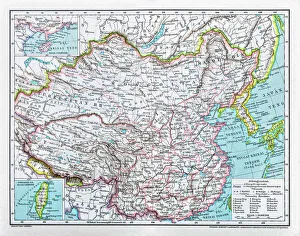
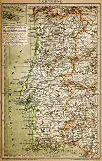
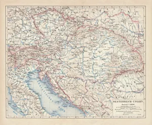
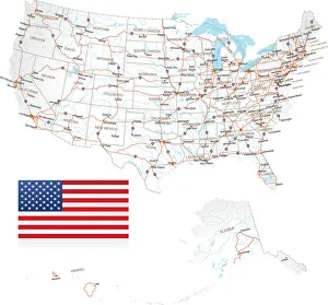
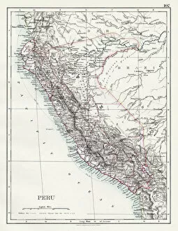
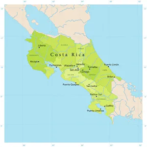
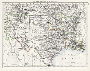
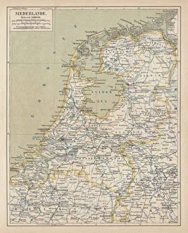
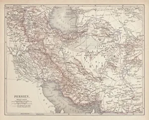
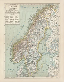
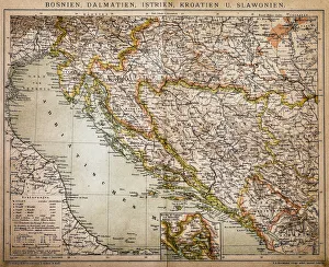
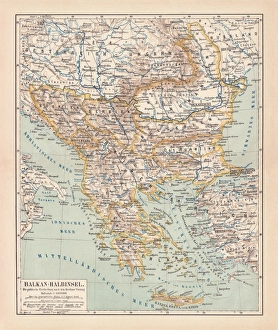
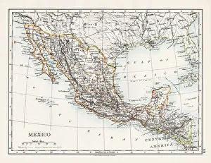
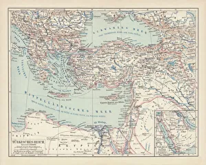
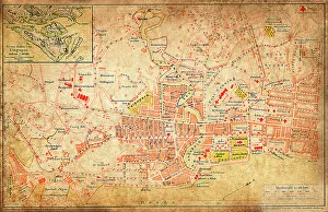
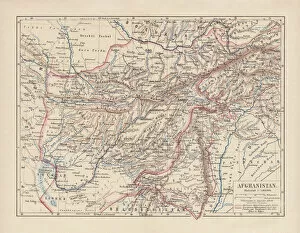
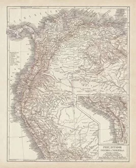
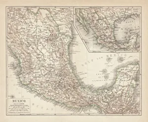
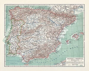
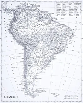
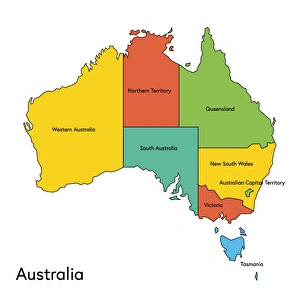
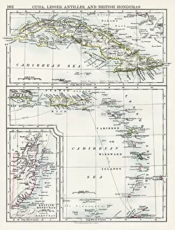
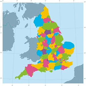
"Exploring the World: A Journey through Country Geographic Areas" Embark on a visual voyage as we delve into the diverse and captivating country geographic areas that have shaped our world. From the enchanting Map of Portugal, with its intricate coastlines and charming towns, to witnessing the mesmerizing sunrise over Angkor Wat in Siem Reap, Cambodia – these snapshots transport us to breathtaking destinations. Discover the vastness of America with a highly detailed USA Road Map, guiding us through its sprawling highways and hidden gems. Marvel at China's vast territory captured in an awe-inspiring map that showcases its rich history and cultural heritage. Transport yourself back in time with lithographs like the Map of Netherlands from 1877 or Peru's historical map from 1897, offering glimpses into bygone eras. Journey through time as you explore United States South West Central map from 1897, envisioning how this region has evolved over centuries. Immerse yourself in Costa Rica's Vector Map, highlighting its lush rainforests and vibrant biodiversity. Delve into history with Austro-Hungarian Empire's Habsburg Monarchy lithograph or Ancient Persia's intricately designed map published in 1877. Lastly, be captivated by Sweden and Norway's shared beauty showcased in a lithograph published in 1878 or embark on an exploration of Balkan Peninsula depicted during an important period in history - 1878. Join us on this extraordinary journey across continents as we celebrate the diversity and magnificence found within each country geographic area. Let these maps ignite your wanderlust and inspire your next adventure.

© Copyright Media Storehouse, All Rights Reserved 2003 - 2025
Facebook     Pinterest     100% Payment Secure     Reviews IO