Poster Print > Europe > United Kingdom > England > London > Museums > London Canal Museum
Poster Print : First geological map of Britain, 1815 C016 / 5683


![]()
Poster Prints from Science Photo Library
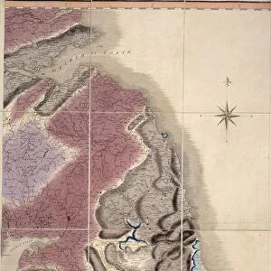
First geological map of Britain, 1815 C016 / 5683
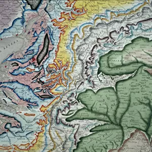
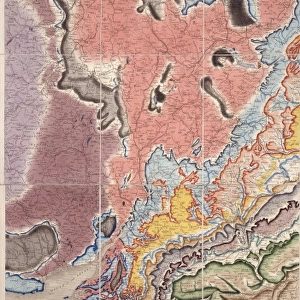
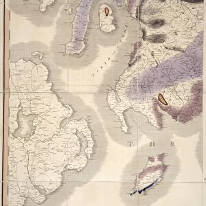
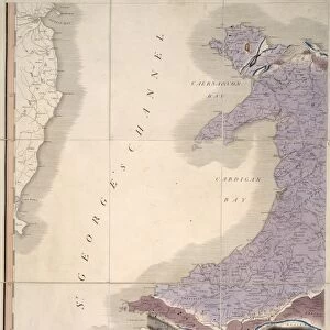
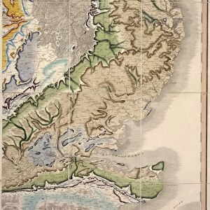
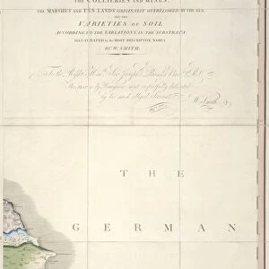
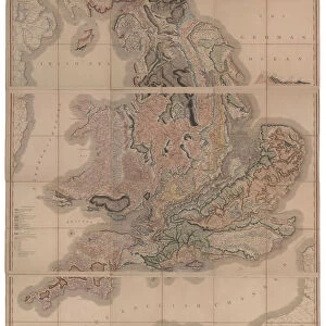
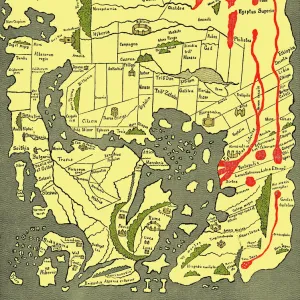
First geological map of Britain, detail of the north east coast (figure 8). This map was published in 1815 by British geologist William Smith (1769-1839). It shows rock layers (strata) in England and Wales and part of Scotland (key at lower left). Smiths work as a canal surveyor allowed him to study geology. He discovered that geological strata could be reliably identified at different places on the basis of the fossils they contained. Smith also proposed the principle of superposition, that if a strata overlays another then it was laid down at a later time. He is considered the father of English geology
Science Photo Library features Science and Medical images including photos and illustrations
Media ID 9206565
© NATURAL HISTORY MUSEUM, LONDON/SCIENCE PHOTO LIBRARY
1815 Cartography Coast Coastal Country Earth Science Geological Great Britain North East Pioneering Region Scottish Strata Stratigraphy Stratum Superposition Welsh William Smith
20x30 inch Poster Print
Introducing the Media Storehouse Poster Prints collection, featuring the historic "First Geological Map of Britain" by William Smith, published in 1815. This iconic map, now part of the Natural History Museum's collection at the Science Photo Library, is a testament to the groundbreaking work of British geologist William Smith. Our high-quality poster prints bring the intricate details of this significant piece of geological history to your home or office. The map, which marked a pivotal moment in the understanding of the Earth's geological structure, is presented in stunning detail. This captivating print is perfect for those with an interest in geology, history, or cartography. Experience the rich history of geological discovery with this exquisite poster print, a captivating addition to any space. Order yours today and bring a piece of scientific heritage into your world.
Poster prints are budget friendly enlarged prints in standard poster paper sizes. Printed on 150 gsm Matte Paper for a natural feel and supplied rolled in a tube. Great for framing and should last many years. To clean wipe with a microfiber, non-abrasive cloth or napkin. Our Archival Quality Photo Prints and Fine Art Paper Prints are printed on higher quality paper and the choice of which largely depends on your budget.
Poster prints are budget friendly enlarged prints in standard poster paper sizes (A0, A1, A2, A3 etc). Whilst poster paper is sometimes thinner and less durable than our other paper types, they are still ok for framing and should last many years. Our Archival Quality Photo Prints and Fine Art Paper Prints are printed on higher quality paper and the choice of which largely depends on your budget.
Estimated Product Size is 51.4cm x 76.8cm (20.2" x 30.2")
These are individually made so all sizes are approximate
Artwork printed orientated as per the preview above, with landscape (horizontal) or portrait (vertical) orientation to match the source image.
FEATURES IN THESE COLLECTIONS
> Asia
> East Timor
> Maps
> Asia
> East Timor
> Related Images
> Europe
> United Kingdom
> England
> London
> Museums
> British Library
> Europe
> United Kingdom
> England
> London
> Museums
> British Museum
> Europe
> United Kingdom
> England
> London
> Museums
> London Canal Museum
> Europe
> United Kingdom
> England
> London
> Museums
> Natural History Museum
> Europe
> United Kingdom
> England
> London
> Museums
> Science Museum
> Europe
> United Kingdom
> England
> London
> Sights
> British Museum
> Europe
> United Kingdom
> England
> London
> Sights
> London Canal Museum
> Europe
> United Kingdom
> England
> London
> Towns
> Lower Place
EDITORS COMMENTS
This print showcases the first geological map of Britain, a groundbreaking work published in 1815 by British geologist William Smith. The map, displayed here in detail of the north east coast (figure 8), provides a comprehensive depiction of rock layers (strata) found across England and Wales, as well as part of Scotland. William Smith's remarkable contribution to geology stemmed from his earlier career as a canal surveyor. Through his meticulous observations, he discovered that different geological strata could be reliably identified based on the fossils they contained. This revolutionary insight allowed for accurate mapping and understanding of Earth's history. Smith also proposed the principle of superposition, which states that if one layer overlays another, it was deposited at a later time. This concept became fundamental to stratigraphy and further solidified Smith's status as the father of English geology. The intricate illustration captures not only the geographical features but also includes a key at the lower left corner explaining various rock formations present in different regions. Its publication marked an important milestone in earth science and cartography during the early 19th century. Preserved by NATURAL HISTORY MUSEUM, LONDON/SCIENCE PHOTO LIBRARY, this artwork serves as an invaluable historical artifact showcasing pioneering research that laid the foundation for modern geological studies.
MADE IN THE USA
Safe Shipping with 30 Day Money Back Guarantee
FREE PERSONALISATION*
We are proud to offer a range of customisation features including Personalised Captions, Color Filters and Picture Zoom Tools
SECURE PAYMENTS
We happily accept a wide range of payment options so you can pay for the things you need in the way that is most convenient for you
* Options may vary by product and licensing agreement. Zoomed Pictures can be adjusted in the Cart.