Poster Print : Portolan chart, 1587. Map of England, Scotland


![]()
Poster Prints From Mary Evans Picture Library
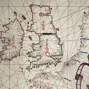
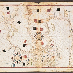
Portolan chart, 1587. Map of England, Scotland
Portolan chart, 1587. Map of England, Scotland and Ireland with the north France coast. Realized in Messina. Facsimile. Renaissance art. Miniature Painting
Mary Evans Picture Library makes available wonderful images created for people to enjoy over the centuries
Media ID 8284275
© Mary Evans Picture Library 2015 - https://copyrighthub.org/s0/hub1/creation/maryevans/MaryEvansPictureID/10681998
Banner Banners Chart Facsimile Geographic Geographical Geography Illuminated Manuscript Manuscripts Messina Miniatures Portolan Renaissance Scot Land
18x24 inch Poster Print
Discover the captivating allure of history with our Media Storehouse Poster Prints featuring the intricately detailed Portolan chart of England, Scotland, and Ireland from 1587. This exquisite map, sourced from the esteemed Mary Evans Prints Online, showcases the artistry of the Renaissance era with its vibrant colors and meticulous brushstrokes. Originally realized in Messina, this Portolan chart is a testament to the cartographic knowledge of the time, displaying the coastlines of England, Scotland, and Ireland, as well as the north French coast. The rich, hand-painted detailing brings the map to life, transporting you back to the era of exploration and discovery. Our high-quality poster prints are perfect for adorning your walls and adding a touch of history and sophistication to any room. With our commitment to preserving the authenticity and beauty of this rare and valuable piece, you can enjoy the splendor of this Portolan chart for generations to come. Bring the past into your present with our Media Storehouse Poster Prints - history has never looked so beautiful.
Poster prints are budget friendly enlarged prints in standard poster paper sizes. Printed on 150 gsm Matte Paper for a natural feel and supplied rolled in a tube. Great for framing and should last many years. To clean wipe with a microfiber, non-abrasive cloth or napkin. Our Archival Quality Photo Prints and Fine Art Paper Prints are printed on higher quality paper and the choice of which largely depends on your budget.
Poster prints are budget friendly enlarged prints in standard poster paper sizes (A0, A1, A2, A3 etc). Whilst poster paper is sometimes thinner and less durable than our other paper types, they are still ok for framing and should last many years. Our Archival Quality Photo Prints and Fine Art Paper Prints are printed on higher quality paper and the choice of which largely depends on your budget.
Estimated Product Size is 46.3cm x 61.6cm (18.2" x 24.3")
These are individually made so all sizes are approximate
Artwork printed orientated as per the preview above, with portrait (vertical) orientation to match the source image.
MADE IN THE USA
Safe Shipping with 30 Day Money Back Guarantee
FREE PERSONALISATION*
We are proud to offer a range of customisation features including Personalised Captions, Color Filters and Picture Zoom Tools
SECURE PAYMENTS
We happily accept a wide range of payment options so you can pay for the things you need in the way that is most convenient for you
* Options may vary by product and licensing agreement. Zoomed Pictures can be adjusted in the Basket.