Photographic Print > Arts > Artists > B > Joan Blaeu
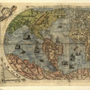
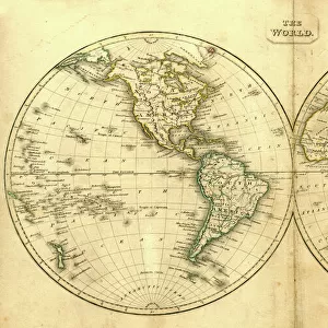
Photographic Print : Nova et Accuratissima Totius Terrarum


![]()
Photo Prints From Universal Images Group (UIG)
Nova et Accuratissima Totius Terrarum
Double Hemisphere Map 1662, Blaeu, Joan
Universal Images Group (UIG) manages distribution for many leading specialist agencies worldwide
Media ID 20165153
Antiquarian Antiquarian Maps Brahe California Double Galileo Globe Hemisphere Island Journeys Left Maps Shown Travels Treks Trip Trips Tycho Voyage Voyages 1662 Astronomers
10"x8" Photo Print
Discover the captivating beauty of the world as it was once perceived with Media Storehouse's Photographic Print of "Nova et Accuratissima Totius Terrarum" by PicturesNow UIG from Universal Images Group (UIG). This classic double hemisphere map, created by renowned cartographer Joan Blaeu in 1662, offers a fascinating glimpse into the geographical knowledge of the past. With meticulous attention to detail and stunning visual clarity, this photographic print transports you back in time, making it an exquisite addition to any home or office decor.
Photo prints are produced on Kodak professional photo paper resulting in timeless and breath-taking prints which are also ideal for framing. The colors produced are rich and vivid, with accurate blacks and pristine whites, resulting in prints that are truly timeless and magnificent. Whether you're looking to display your prints in your home, office, or gallery, our range of photographic prints are sure to impress. Dimensions refers to the size of the paper in inches.
Our Photo Prints are in a large range of sizes and are printed on Archival Quality Paper for excellent colour reproduction and longevity. They are ideal for framing (our Framed Prints use these) at a reasonable cost. Alternatives include cheaper Poster Prints and higher quality Fine Art Paper, the choice of which is largely dependant on your budget.
Estimated Product Size is 25.4cm x 20.3cm (10" x 8")
These are individually made so all sizes are approximate
Artwork printed orientated as per the preview above, with landscape (horizontal) or portrait (vertical) orientation to match the source image.
FEATURES IN THESE COLLECTIONS
> Animals
> Fishes
> G
> Grouper
> Arts
> Artists
> B
> Joan Blaeu
> Maps and Charts
> Related Images
> Maps and Charts
> World
> Universal Images Group (UIG)
> History
> Historical Maps
EDITORS COMMENTS
This stunning print showcases the "Nova et Accuratissima Totius Terrarum" map, created by Joan Blaeu in 1662. With its intricate details and vibrant colors, this antique double hemisphere map takes us back to a time when astronomers like Galileo and Tycho Brahe were making groundbreaking discoveries about our world. On the left side of the map, we see various islands and continents beautifully depicted, inviting us on a visual journey across the globe. From California's recognizable shape to lesser-known lands waiting to be explored, this map captures the curiosity of early travelers and their treks into uncharted territories. The top portion reveals an array of celestial bodies that fascinated astronomers during this era. The Earth is shown as a central focus within these heavenly spheres, emphasizing humanity's place in the vastness of space. As we gaze upon this remarkable piece of history, it transports us back to a time when maps were not just tools for navigation but also works of art. It reminds us of our ancestors' thirst for knowledge and their desire to understand the world around them through voyages and expeditions. Thanks to PicturesNow UIG from Universal Images Group (UIG), we can now appreciate every intricate detail of this antique masterpiece in all its glory.
MADE IN THE USA
Safe Shipping with 30 Day Money Back Guarantee
FREE PERSONALISATION*
We are proud to offer a range of customisation features including Personalised Captions, Color Filters and Picture Zoom Tools
SECURE PAYMENTS
We happily accept a wide range of payment options so you can pay for the things you need in the way that is most convenient for you
* Options may vary by product and licensing agreement. Zoomed Pictures can be adjusted in the Basket.