Canvas Print > Arts > Artists > B > Joan Blaeu
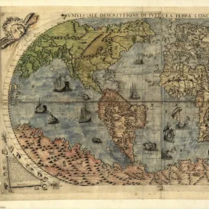
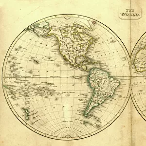
Canvas Print : Nova et Accuratissima Totius Terrarum


![]()
Canvas Prints From Universal Images Group (UIG)
Nova et Accuratissima Totius Terrarum
Double Hemisphere Map 1662, Blaeu, Joan
Universal Images Group (UIG) manages distribution for many leading specialist agencies worldwide
Media ID 20165153
Antiquarian Antiquarian Maps Brahe California Double Galileo Globe Hemisphere Island Journeys Left Maps Shown Travels Treks Trip Trips Tycho Voyage Voyages 1662 Astronomers
20"x16" (51x41cm) Canvas Print
Experience the captivating allure of the past with Media Storehouse's Canvas Prints. This exquisite piece features "Nova et Accuratissima Totius Terrarum" by PicturesNow UIG from Universal Images Group (UIG), a rare and intriguing double hemisphere map dating back to 1662, created by the renowned cartographer Joan Blaeu. Each Canvas Print is meticulously crafted with premium materials, ensuring vibrant colors and exceptional detail that bring history to life in your home or office. Transport yourself back in time with this stunning, museum-quality artwork.
Delivered stretched and ready to hang our premium quality canvas prints are made from a polyester/cotton blend canvas and stretched over a 1.25" (32mm) kiln dried knot free wood stretcher bar. Packaged in a plastic bag and secured to a cardboard insert for safe transit.
Canvas Prints add colour, depth and texture to any space. Professionally Stretched Canvas over a hidden Wooden Box Frame and Ready to Hang
Estimated Product Size is 50.8cm x 40.6cm (20" x 16")
These are individually made so all sizes are approximate
Artwork printed orientated as per the preview above, with landscape (horizontal) orientation to match the source image.
FEATURES IN THESE COLLECTIONS
> Animals
> Fishes
> G
> Grouper
> Arts
> Artists
> B
> Joan Blaeu
> Maps and Charts
> Related Images
> Maps and Charts
> World
> Universal Images Group (UIG)
> History
> Historical Maps
EDITORS COMMENTS
This stunning print showcases the "Nova et Accuratissima Totius Terrarum" map, created by Joan Blaeu in 1662. With its intricate details and vibrant colors, this antique double hemisphere map takes us back to a time when astronomers like Galileo and Tycho Brahe were making groundbreaking discoveries about our world. On the left side of the map, we see various islands and continents beautifully depicted, inviting us on a visual journey across the globe. From California's recognizable shape to lesser-known lands waiting to be explored, this map captures the curiosity of early travelers and their treks into uncharted territories. The top portion reveals an array of celestial bodies that fascinated astronomers during this era. The Earth is shown as a central focus within these heavenly spheres, emphasizing humanity's place in the vastness of space. As we gaze upon this remarkable piece of history, it transports us back to a time when maps were not just tools for navigation but also works of art. It reminds us of our ancestors' thirst for knowledge and their desire to understand the world around them through voyages and expeditions. Thanks to PicturesNow UIG from Universal Images Group (UIG), we can now appreciate every intricate detail of this antique masterpiece in all its glory.
MADE IN THE USA
Safe Shipping with 30 Day Money Back Guarantee
FREE PERSONALISATION*
We are proud to offer a range of customisation features including Personalised Captions, Color Filters and Picture Zoom Tools
SECURE PAYMENTS
We happily accept a wide range of payment options so you can pay for the things you need in the way that is most convenient for you
* Options may vary by product and licensing agreement. Zoomed Pictures can be adjusted in the Basket.