Photographic Print > Sheffield City Archives > Maps and Plans > Bowen's County Maps, c. 1777
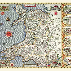
Photographic Print : Map of North Wales, c. 1777


![]()
Photo Prints From Sheffield City Archives
Map of North Wales, c. 1777
From The Large English Atlas: or, a new set of map of all the counties of England and Wales drawn from the several surveys which have been hitherto been published. With three general maps of England, Scotland and Ireland, from the latest and best authorities, by Emanuel Bowen, Thomas Kitchin and others. London, printed and sold by T. Bowles, [c.1777]
Original at Sheffield Libraries: 912 STF
Sheffield City Archives and Local Studies Library has an unrivalled collection of images of Sheffield, England
Media ID 25501443
© Sheffield City Council - All Rights Reserved
Antique Map Bowens Map County Map Emanuel Bowen Old Map Thomas Kitchin Aberdovey Abergele Anglesey Bala Bangor Barmouth Betws Y Coed Blaenau Ffestiniog Caernarfon Caernarfonshire Caernarvonshire Carnarvonshire Colwyn Bay Conwy Corwen Denbigh Denbighshire Dolgellau Ffestiniog Harlech Llandudno Llangollen Llanidloes Llanrwst Machynlleth Merionethshire Montgomery Montgomeryshire Newtown Porthmadog Pwllheli Rhyl Ruthin Snowdon Snowdonia Tywyn Welshpool Wrexham
10"x8" Photo Print
Discover the rich history of North Wales with our exquisite Media Storehouse Photographic Print of a rare 1777 map from The Large English Atlas, held in the Sheffield City Archives. This stunning print showcases intricate cartographic details of North Wales during this historical period, making it a must-have for history enthusiasts, collectors, and those with a deep connection to the region. Bring a piece of the past into your home or office with this beautifully preserved and expertly printed reproduction. Order yours today and journey back in time.
Photo prints are produced on Kodak professional photo paper resulting in timeless and breath-taking prints which are also ideal for framing. The colors produced are rich and vivid, with accurate blacks and pristine whites, resulting in prints that are truly timeless and magnificent. Whether you're looking to display your prints in your home, office, or gallery, our range of photographic prints are sure to impress. Dimensions refers to the size of the paper in inches.
Our Photo Prints are in a large range of sizes and are printed on Archival Quality Paper for excellent colour reproduction and longevity. They are ideal for framing (our Framed Prints use these) at a reasonable cost. Alternatives include cheaper Poster Prints and higher quality Fine Art Paper, the choice of which is largely dependant on your budget.
Estimated Product Size is 25.4cm x 20.3cm (10" x 8")
These are individually made so all sizes are approximate
Artwork printed orientated as per the preview above, with landscape (horizontal) or portrait (vertical) orientation to match the source image.
FEATURES IN THESE COLLECTIONS
> Sheffield City Archives
> Maps and Plans
> Bowen's County Maps, c. 1777
> Sheffield City Archives
> Maps and Plans
> Maps of Wales
EDITORS COMMENTS
This antique map print showcases the stunning "Map of North Wales" from around 1777. Originally featured in "The Large English Atlas: or, a new set of maps of all the counties of England and Wales" this historical piece was meticulously drawn by renowned cartographers Emanuel Bowen, Thomas Kitchin, and others. The map provides a fascinating glimpse into the geographical landscape of North Wales during that era. It highlights prominent locations such as Anglesey, Caernarfonshire (also known as Caernarvonshire or Carnarvonshire), Snowdonia with its majestic peak Snowdon, Bardsey Island, Bangor, Betws-y-Coed, Caernarfon, Conwy, Porthmadog, Pwllheli, Llandudno and many more. With intricate details and precise markings denoting towns like Denbighshire's Rhyl and Abergele to Denbigh's Mochdre; from Llangollen to Llanrwst; Wrexham to Colwyn Bay; Ruthin to Merionethshire's Dolgellau; Aberdovey to Bala; Barmouth to Blaenau Ffestiniog; Corwen to Ffestiniog; Harlech to Tywyn - it offers an invaluable historical record. Preserved at Sheffield Libraries under reference number 912 STF within their archives collection is where this remarkable original can be found. Its depiction serves as a testament not only to
MADE IN THE USA
Safe Shipping with 30 Day Money Back Guarantee
FREE PERSONALISATION*
We are proud to offer a range of customisation features including Personalised Captions, Color Filters and Picture Zoom Tools
SECURE PAYMENTS
We happily accept a wide range of payment options so you can pay for the things you need in the way that is most convenient for you
* Options may vary by product and licensing agreement. Zoomed Pictures can be adjusted in the Basket.