Photographic Print > North Wind Picture Archives > British history
Photographic Print : GGBR2A-00069

![]()
Photo Prints from North Wind
GGBR2A-00069
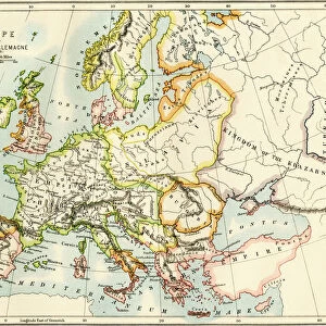
Map of English holdings in the 10th and 11th centuries, showing earldomes and vassal kingdoms.
Printed color lithograph, 19th-century
North Wind Picture Archives brings history to life with stock images and hand-colored illustrations
Media ID 5879212
© North Wind Picture Archives
10th Century 11th Century 900s British England English Europe Feudalism Great Britain Medieval Middle Ages Norman Conquest North Umberland Scot Land Wales William The Conqueror Kingdoms
11"x8.5" Photo Print
Step back in time with Media Storehouse's exquisite range of Photographic Prints, featuring the intricately detailed map "GGBR2A-00069" from North Wind Picture Archives. This captivating 19th-century color lithograph offers a breathtaking view of English holdings during the 10th and 11th centuries, meticulously depicting earldoms and vassal kingdoms. Bring history to life in your home or office with this stunning, high-quality print.
Photo prints are produced on Kodak professional photo paper resulting in timeless and breath-taking prints which are also ideal for framing. The colors produced are rich and vivid, with accurate blacks and pristine whites, resulting in prints that are truly timeless and magnificent. Whether you're looking to display your prints in your home, office, or gallery, our range of photographic prints are sure to impress. Dimensions refers to the size of the paper in inches.
Our Photo Prints are in a large range of sizes and are printed on Archival Quality Paper for excellent colour reproduction and longevity. They are ideal for framing (our Framed Prints use these) at a reasonable cost. Alternatives include cheaper Poster Prints and higher quality Fine Art Paper, the choice of which is largely dependant on your budget.
Estimated Image Size (if not cropped) is 17cm x 27.9cm (6.7" x 11")
Estimated Product Size is 21.6cm x 27.9cm (8.5" x 11")
These are individually made so all sizes are approximate
Artwork printed orientated as per the preview above, with portrait (vertical) orientation to match the source image.
FEATURES IN THESE COLLECTIONS
> North Wind Picture Archives
> British history
> North Wind Picture Archives
> Maps
EDITORS COMMENTS
This vintage print showcases a captivating glimpse into the history of Great Britain during the 10th and 11th centuries. Titled "GGBR2A-00069" this remarkable lithograph depicts an intricately detailed map of English holdings, including earldomes and vassal kingdoms. The vibrant colors bring to life the medieval landscape, transporting viewers back in time. The map highlights significant regions such as Northumberland, Wales, Scotland, and England itself. It provides a visual representation of the power dynamics that shaped British history during this era. Notably, it captures the impact of William the Conqueror's Norman Conquest on these lands. As one delves deeper into this artwork, they are immersed in a world governed by feudalism and divided into various earldoms. This print serves as both an educational tool for historians and a stunning piece of art for enthusiasts interested in medieval times. With its rich historical context and meticulous attention to detail, this lithograph offers a unique perspective on European history from over a millennium ago. Whether displayed in homes or educational institutions, it sparks curiosity about our ancestors' lives while reminding us of their enduring influence on modern-day society
MADE IN THE USA
Safe Shipping with 30 Day Money Back Guarantee
FREE PERSONALISATION*
We are proud to offer a range of customisation features including Personalised Captions, Color Filters and Picture Zoom Tools
SECURE PAYMENTS
We happily accept a wide range of payment options so you can pay for the things you need in the way that is most convenient for you
* Options may vary by product and licensing agreement. Zoomed Pictures can be adjusted in the Cart.