Photo Mug > Universal Images Group (UIG) > Art > Painting, Sculpture & Prints > Cartography
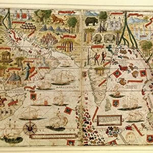
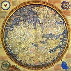
Photo Mug : Map of India, from Atlas by Al Idrisi, circa 1099-1165, manuscript


![]()
Home Decor From Universal Images Group (UIG)
Map of India, from Atlas by Al Idrisi, circa 1099-1165, manuscript
Cartography, Asia, 11th century. Map of India, from Atlas by Al Idrisi (circa 1099-1165), manuscript
Universal Images Group (UIG) manages distribution for many leading specialist agencies worldwide
Media ID 9500387
© DEA / G. DAGLI ORTI
11th Century Coastline Colorful India Manuscript Open Page Al Idrisi
Large Photo Mug (15 oz)
Add a touch of history to your daily routine with our Media Storehouse Photo Mug featuring a captivating map of India from the Atlas by Al Idrisi, circa 11th century. This intricately detailed map, sourced from the Universal Images Group, showcases the rich cartographic history of Asia. Each mug holds your favorite beverage and serves as a conversation starter, making it an ideal gift for history enthusiasts or anyone who appreciates the beauty of ancient maps. Embrace the past, one sip at a time.
Elevate your coffee or tea experience with our premium white ceramic mug. Its wide, comfortable handle makes drinking easy, and you can rely on it to be both microwave and dishwasher safe. Sold in single units, preview may show both sides of the same mug so you can see how the picture wraps around.
Elevate your coffee or tea experience with our premium white ceramic mug. Its wide, comfortable handle makes drinking easy, and you can rely on it to be both microwave and dishwasher safe. Sold in single units, preview may show both sides of the same mug so you can see how the picture wraps around.
These are individually made so all sizes are approximate
EDITORS COMMENTS
This vibrant and historically significant print showcases a Map of India, extracted from the Atlas by Al Idrisi, a renowned cartographer who lived between 1099 and 1165. Crafted during the 11th century, this manuscript exemplifies the remarkable artistry and precision of ancient mapmaking. The colorful topography depicted in this horizontal page reveals intricate details of India's geography. From its vast coastline to its diverse inland regions, every contour is meticulously illustrated with great care. The open sea surrounding the country adds an element of depth and adventure to this artwork. What makes this image truly extraordinary is its historical context. Created centuries ago, it offers us a glimpse into how people perceived and understood their world at that time. This manuscript serves as a testament to Al Idrisi's expertise in cartography, showcasing his dedication to accurately representing geographical features. As we admire this photograph, we are transported back in time when maps were not just tools for navigation but also works of art. With no people present within the frame, our focus solely rests on appreciating the craftsmanship behind this masterpiece. Whether you are an enthusiast of history or simply captivated by India's rich cultural heritage, this print from Universal Images Group (UIG) provides an enchanting window into both past cartographic techniques and the beauty of Indian landscapes
MADE IN THE USA
Safe Shipping with 30 Day Money Back Guarantee
FREE PERSONALISATION*
We are proud to offer a range of customisation features including Personalised Captions, Color Filters and Picture Zoom Tools
SECURE PAYMENTS
We happily accept a wide range of payment options so you can pay for the things you need in the way that is most convenient for you
* Options may vary by product and licensing agreement. Zoomed Pictures can be adjusted in the Basket.