Metal Print > Universal Images Group (UIG) > Art > Painting, Sculpture & Prints > Cartography
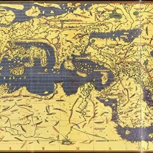
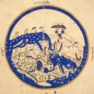
Metal Print : Map of India, from Atlas by Al Idrisi, circa 1099-1165, manuscript


![]()
Metal Prints From Universal Images Group (UIG)
Map of India, from Atlas by Al Idrisi, circa 1099-1165, manuscript
Cartography, Asia, 11th century. Map of India, from Atlas by Al Idrisi (circa 1099-1165), manuscript
Universal Images Group (UIG) manages distribution for many leading specialist agencies worldwide
Media ID 9500387
© DEA / G. DAGLI ORTI
11th Century Coastline Colorful India Manuscript Open Page Al Idrisi
16"x20" (51x41cm) Metal Print
Step back in time with our stunning Media Storehouse Metal Print of the Map of India from the Atlas by Al Idrisi. Dating back to the 11th century, this intricately detailed map is a captivating piece of cartographic history. Originally from a manuscript by the renowned Moroccan cartographer Al Idrisi, this map showcases the intricacies of India as known during the Middle Ages. Bring the rich history of Asia into your home or office with this beautiful and unique metal print, expertly printed on high-quality metal for a vibrant and long-lasting display. A perfect addition to any space for history enthusiasts, world travelers, or those who appreciate the beauty of ancient maps.
Made with durable metal and luxurious printing techniques, our metal photo prints go beyond traditional canvases, adding a cool, modern touch to your space. Wall mount on back. Eco-friendly 100% post-consumer recycled ChromaLuxe aluminum surface. The thickness of the print is 0.045". Featuring a Scratch-resistant surface and Rounded corners. Backing hangers are attached to the back of the print and float the print 1/2-inch off the wall when hung, the choice of hanger may vary depending on size and International orders will come with Float Mount hangers only. Finished with a brilliant white high gloss surface for unsurpassed detail and vibrance. Printed using Dye-Sublimation and for best care we recommend a non-ammonia glass cleaner, water, or isopropyl (rubbing) alcohol to prevent harming the print surface. We recommend using a clean, lint-free cloth to wipe off the print. The ultra-hard surface is scratch-resistant, waterproof and weatherproof. Avoid direct sunlight exposure.
Made with durable metal and luxurious printing techniques, metal prints bring images to life and add a modern touch to any space
Estimated Image Size (if not cropped) is 50.8cm x 40.6cm (20" x 16")
Estimated Product Size is 51.4cm x 41.2cm (20.2" x 16.2")
These are individually made so all sizes are approximate
Artwork printed orientated as per the preview above, with landscape (horizontal) orientation to match the source image.
EDITORS COMMENTS
This vibrant and historically significant print showcases a Map of India, extracted from the Atlas by Al Idrisi, a renowned cartographer who lived between 1099 and 1165. Crafted during the 11th century, this manuscript exemplifies the remarkable artistry and precision of ancient mapmaking. The colorful topography depicted in this horizontal page reveals intricate details of India's geography. From its vast coastline to its diverse inland regions, every contour is meticulously illustrated with great care. The open sea surrounding the country adds an element of depth and adventure to this artwork. What makes this image truly extraordinary is its historical context. Created centuries ago, it offers us a glimpse into how people perceived and understood their world at that time. This manuscript serves as a testament to Al Idrisi's expertise in cartography, showcasing his dedication to accurately representing geographical features. As we admire this photograph, we are transported back in time when maps were not just tools for navigation but also works of art. With no people present within the frame, our focus solely rests on appreciating the craftsmanship behind this masterpiece. Whether you are an enthusiast of history or simply captivated by India's rich cultural heritage, this print from Universal Images Group (UIG) provides an enchanting window into both past cartographic techniques and the beauty of Indian landscapes
MADE IN THE USA
Safe Shipping with 30 Day Money Back Guarantee
FREE PERSONALISATION*
We are proud to offer a range of customisation features including Personalised Captions, Color Filters and Picture Zoom Tools
SECURE PAYMENTS
We happily accept a wide range of payment options so you can pay for the things you need in the way that is most convenient for you
* Options may vary by product and licensing agreement. Zoomed Pictures can be adjusted in the Basket.