Photo Mug > Animals > Mammals > Muridae > Western Mouse
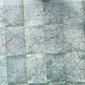
Photo Mug : Glossary on a trench map of NW France, WW1


![]()
Home Decor From Mary Evans Picture Library
Glossary on a trench map of NW France, WW1
Glossary on the back of a trench map of NW France, for the Peronne area, including Bouchavesnes, sheet 62c NW, dated 20 November 1916. The Glossary was included to help British troops understand signs written in French. Date: 1916
Mary Evans Picture Library makes available wonderful images created for people to enjoy over the centuries
Media ID 14417080
© The Patricia Aubrey Collection / Mary Evans
Area Auerbach Language Peronne Sheet Translation Trench
Photo Mug (11 oz)
Step back in time with our Media Storehouse Photo Mug, featuring an intriguing image of a WW1 trench map from Mary Evans Prints Online. This unique mug showcases a glossary overlaid on a historic map of the NW France battlefield, specifically the Peronne area including Bouchavesnes, sheet 62c NW, dated 20 November 1916. Perfect for history enthusiasts, this mug is not just a beverage holder, but a conversation starter and a tribute to the past. Embrace the blend of history and functionality with every sip.
A personalized photo mug blends sentimentality with functionality, making an ideal gift for cherished loved ones, close friends, or valued colleagues. Preview may show both sides of the same mug.
Elevate your coffee or tea experience with our premium white ceramic mug. Its wide, comfortable handle makes drinking easy, and you can rely on it to be both microwave and dishwasher safe. Sold in single units, preview may show both sides of the same mug so you can see how the picture wraps around.
Mug Size is 8cm high x 9.5cm diameter (3.1" x 3.7")
These are individually made so all sizes are approximate
FEATURES IN THESE COLLECTIONS
> Animals
> Mammals
> Muridae
> Western Mouse
> Maps and Charts
> Related Images
> Maps and Charts
> World
EDITORS COMMENTS
This evocative trench map from the Western Front during World War I depicts the NW France area around Peronne, with a specific focus on the village of Bouchavesnes, as outlined in sheet 62c NW. Dated November 20, 1916, this map was a crucial tool for British troops as they navigated the complex terrain and communicated with local French inhabitants. The back of the map features an essential glossary, designed to help soldiers decipher French signs and instructions they would encounter in their daily operations. The glossary includes essential military and everyday terms, such as "Auberchicourt" (a nearby town), "Boche" (a derogatory term for German soldiers), "Sap" (a trench dug close to the enemy lines), and "Stretcher Bearer" (a medical aid worker). The inclusion of this glossary was a testament to the importance of effective communication during wartime, as troops relied on each other and local civilians to coordinate movements, gather intelligence, and ensure the safety and well-being of their comrades. This map and its accompanying glossary serve as a poignant reminder of the intricacies and challenges of military life during the 1910s and the First World War.
MADE IN THE USA
Safe Shipping with 30 Day Money Back Guarantee
FREE PERSONALISATION*
We are proud to offer a range of customisation features including Personalised Captions, Color Filters and Picture Zoom Tools
SECURE PAYMENTS
We happily accept a wide range of payment options so you can pay for the things you need in the way that is most convenient for you
* Options may vary by product and licensing agreement. Zoomed Pictures can be adjusted in the Basket.