Home > Europe > Luxembourg > Maps
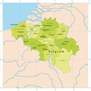
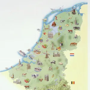
Map of Belgium, France and Luxembourg

![]()
Wall Art and Photo Gifts from Mary Evans Picture Library
Map of Belgium, France and Luxembourg
Map of Belgium, France and Luxembourg. Made by Michaelis Tramezini, 1558. Printed by Iacobus Bossius
Mary Evans Picture Library makes available wonderful images created for people to enjoy over the centuries
Media ID 14337059
© Thaliastock / Mary Evans
1558 Cartography Holland Luxembourg Mapping Michaelis
FEATURES IN THESE COLLECTIONS
> Europe
> Luxembourg
> Maps
> Maps and Charts
> Early Maps
> Maps and Charts
> Luxembourg
EDITORS COMMENTS
This exquisite map print, created by the renowned cartographer Michaelis Tramezini in 1558 and printed by Iacobus Bossius, offers a fascinating glimpse into the geography of Europe during the 16th century. The map depicts the regions of Belgium, France, and Luxembourg with remarkable detail and accuracy for the time. Tramezini's map is a testament to the advancements in cartography during the modern age. The intricate lines and borders represent the latest knowledge of the territories, showcasing the political divisions and geographical features of the time. The map includes the Dutch provinces, which were an integral part of the region, further emphasizing the interconnectedness of the European landscape. The map's antique charm lies in its intricate details, such as the winding rivers, the meticulously drawn coastlines, and the various cities and towns marked with their names. The map also features illustrations of castles, fortifications, and other landmarks, adding to its historical significance. This map is a valuable historical artifact, offering insights into the geographical knowledge and cartographic techniques of the 16th century. It is a testament to the curiosity and exploration that characterized the age, as well as the importance of accurate mapping for political and strategic purposes. The map's intricate details and historical significance make it a must-have for collectors of antique maps, historians, and anyone interested in the history of Europe and cartography.
MADE IN THE USA
Safe Shipping with 30 Day Money Back Guarantee
FREE PERSONALISATION*
We are proud to offer a range of customisation features including Personalised Captions, Color Filters and Picture Zoom Tools
SECURE PAYMENTS
We happily accept a wide range of payment options so you can pay for the things you need in the way that is most convenient for you
* Options may vary by product and licensing agreement. Zoomed Pictures can be adjusted in the Cart.